開啟輔助訪問
 找回密碼
 立即加入

04L.Danny 登陸南卡羅來納州

簽到天數: 1650 天

[LV.Master]伴壇終老

老農民版夜神月|2021-6-29 04:54 | 顯示全部樓層
本帖最後由 老農民版夜神月 於 2021-6-29 06:50 編輯

NHC19Z命名Danny
018
WTNT64 KNHC 281905
TCUAT4

Tropical Storm Danny Tropical Cyclone Update
NWS National Hurricane Center Miami FL       AL042021
305 PM EDT Mon Jun 28 2021


...DEPRESSION STRENGTHENS TO A TROPICAL STORM...

Doppler radar data from Charleston, South Carolina, along with
preliminary data from an Air Force Reserve reconnaissance aircraft,
indicate that the depression has strengthened and is now Tropical
Storm Danny. The maximum sustained winds are estimated to be 40 mph
(65 km/h) with higher gusts.

A Weatherflow station at Folly Beach, South Carolina, recently
reported a wind gust of 41 mph (66 km/h).

SUMMARY OF 305 PM EDT...1905 UTC...INFORMATION
----------------------------------------------
LOCATION...32.2N 79.7W
ABOUT 60 MI...95 KM ESE OF BEAUFORT SOUTH CAROLINA
ABOUT 45 MI...70 KM SSE OF CHARLESTON SOUTH CAROLINA
MAXIMUM SUSTAINED WINDS...40 MPH...65 KM/H
PRESENT MOVEMENT...WNW OR 325 DEGREES AT 16 MPH...26 KM/H
MINIMUM CENTRAL PRESSURE...1014 MB...29.94 INCHES

$$
Forecaster Stewart
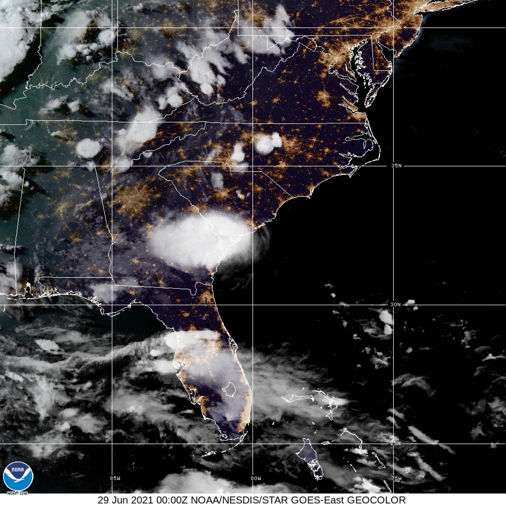
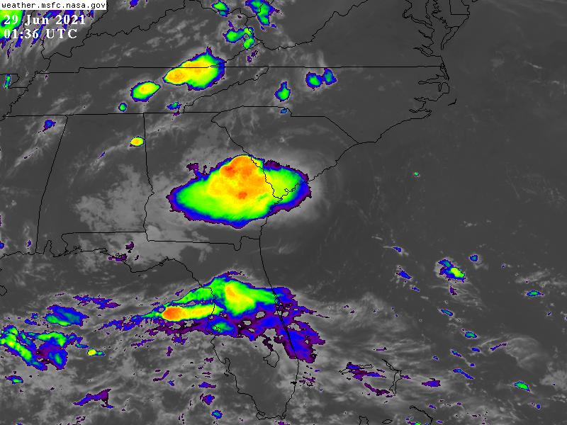
204525_5day_cone_no_line_and_wind.png al042021 (1).gif 20211792100_GOES16-ABI-FL-GEOCOLOR-AL042021-1000x1000.jpg
回復

使用道具 舉報

簽到天數: 1650 天

[LV.Master]伴壇終老

老農民版夜神月|2021-6-29 09:44 | 顯示全部樓層
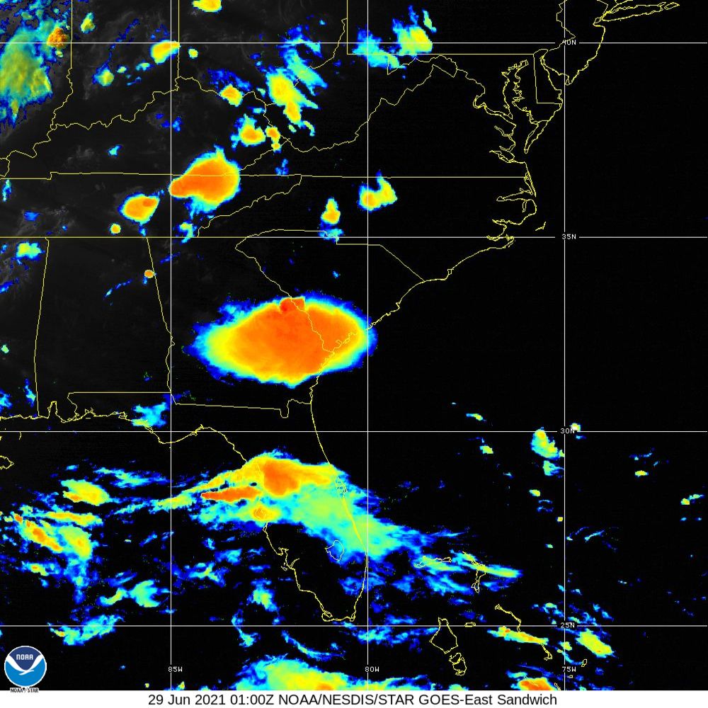
約於00Z登陸美國南卡羅來納州
WTNT34 KNHC 282349
TCPAT4

BULLETIN
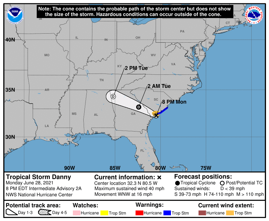
Tropical Storm Danny Intermediate Advisory Number 2A
NWS National Hurricane Center Miami FL       AL042021
800 PM EDT Mon Jun 28 2021

...DANNY MAKES LANDFALL JUST NORTH OF HILTON HEAD ON PRITCHARDS
ISLAND SOUTH CAROLINA...


SUMMARY OF 800 PM EDT...0000 UTC...INFORMATION
----------------------------------------------
LOCATION...32.3N 80.5W
ABOUT 15 MI...20 KM ESE OF BEAUFORT SOUTH CAROLINA
ABOUT 50 MI...80 KM SW OF CHARLESTON SOUTH CAROLINA
MAXIMUM SUSTAINED WINDS...40 MPH...65 KM/H
PRESENT MOVEMENT...WNW OR 290 DEGREES AT 16 MPH...26 KM/H
MINIMUM CENTRAL PRESSURE...1010 MB...29.82 INCHES


WATCHES AND WARNINGS
--------------------
CHANGES WITH THIS ADVISORY:

None.

SUMMARY OF WATCHES AND WARNINGS IN EFFECT:

A Tropical Storm Warning is in effect for...
* Edisto Beach to South Santee River South Carolina

A Tropical Storm Warning means that tropical storm conditions are
expected somewhere within the warning area.

For storm information specific to your area, including possible
inland watches and warnings, please monitor products issued by your
local National Weather Service forecast office.


DISCUSSION AND OUTLOOK
----------------------
At 800 PM EDT (0000 UTC), the center of Tropical Storm Danny was
located near latitude 32.3 North, longitude 80.5 West. Danny is
moving toward the west-northwest near 16 mph (26 km/h) and this
general motion is expected to continue during the next day or so.
On the forecast track, Danny will move inland across southern South
Carolina and east-central Georgia tonight and early Tuesday morning.

Data from NOAA Doppler radars, earlier reconnaissance aircraft, and
surface observations indicate that maximum sustained winds are near
40 mph (65 km/h) with higher gusts. Rapid weakening is forecast,
and Danny is expected to weaken to a tropical depression later
tonight and dissipate by late Tuesday.

Tropical-storm-force winds extend outward up to 35 miles (55 km)
from the center.  A wind gust of 34 mph (55 k/h) was recently
reported at Beaufort Airport in South Carolina.

The minimum central pressure based on surface observations is
estimated to be 1010 mb (29.82 inches).


HAZARDS AFFECTING LAND
----------------------
Key messages for Tropical Storm Danny can be found in the Tropical
Cyclone Discussion under AWIPS header MIATCDAT4, WMO header WTNT44
KNHC and on the web at
www.hurricanes.gov/graphics_at4.shtml?key_messages.

WIND:  Tropical storm conditions are expected to continue in the
warning area during the next few hours.

RAINFALL:  Danny could produce 1 to 3 inches of rainfall with
locally higher amounts along the immediate coasts of Georgia and
southern South Carolina. This region has been dry, limiting
potential widespread flooding impacts, however, local flooding
impacts, especially in urban areas along the southern South Carolina
and Georgia coasts, cannot be ruled out at this time.

Farther inland, 1 to 2 inches of rainfall is possible across Upstate
South Carolina, the Piedmont of Georgia, and into northeastern
Alabama.

STORM SURGE:  The combination of storm surge and the tide will cause
normally dry areas near the coast to be flooded by rising waters
moving inland from the shoreline.  The water could reach the
following heights above ground somewhere in the indicated areas if
the peak surge occurs at the time of high tide...

Port Royal Sound, SC to South Santee River, SC...1 to 3 ft

Surge-related flooding depends on the relative timing of the surge
and the tidal cycle, and can vary greatly over short distances.  For
information specific to your area, please see products issued by
your local National Weather Service forecast office.

TORNADOES:  An isolated tornado will be possible this evening along
the South Carolina coast.


NEXT ADVISORY
-------------
Next complete advisory at 1100 PM EDT.

$$
Forecaster Cangialosi
234937_5day_cone_no_line_and_wind.png
20211800000_GOES16-ABI-FL-GEOCOLOR-AL042021-1000x1000.jpg
GOES01362021180ltMpR0.jpg 20211800100_GOES16-ABI-FL-Sandwich-AL042021-1000x1000.jpg
回復

使用道具 舉報

簽到天數: 483 天

[LV.9]以壇為家II

dom|2021-6-29 10:50 | 顯示全部樓層
NHC00Z降格TD
000
WTNT44 KNHC 290232
TCDAT4

Tropical Depression Danny Discussion Number   3
NWS National Hurricane Center Miami FL       AL042021
1100 PM EDT Mon Jun 28 2021

Danny made landfall just north of Hilton Head on Pritchards Island,
South Carolina, around 2330 UTC with maximum winds of about 35 kt.
Since then, the storm moved inland across extreme southern South
Carolina and is now located over east-central Georgia.  Surface
observations and Doppler radar data indicate that Danny has
weakened, and the cyclone has now been downgraded to a 30-kt
tropical depression.  Heavy rains associated with the depression
are spreading westward across central Georgia.

The weakening cyclone is moving west-northwestward at about 13 kt.
This general motion is expected to continue overnight and Tuesday
taking Danny, or its remnants, across Georgia and northern Alabama.
As the system continues its trek inland, additional weakening is
forecast, and Danny will likely dissipate by late Tuesday.


Key Messages:

1. Heavy rainfall is possible from coastal southern South Carolina
and Georgia, inland across the Piedmont of Georgia into northeast
Alabama.  Isolated flooding is possible across urban areas of the
southern South Carolina and Georgia coasts.


FORECAST POSITIONS AND MAX WINDS

INIT  29/0300Z 32.6N  81.5W   30 KT  35 MPH...INLAND
12H  29/1200Z 33.3N  83.8W   20 KT  25 MPH...INLAND
24H  30/0000Z...DISSIPATED

$$
Forecaster Cangialosi
4A9915CD-25E1-4F6B-886E-5E964C9EE9D8.png
回復

使用道具 舉報

簽到天數: 483 天

[LV.9]以壇為家II

dom|2021-6-29 16:53 | 顯示全部樓層
NHC09Z降格殘餘低壓
235
WTNT44 KNHC 290847
TCDAT4

Remnants Of Danny Discussion Number   4
NWS National Hurricane Center Miami FL       AL042021
500 AM EDT Tue Jun 29 2021

Surface observations indicate that the low-level circulation
associated with Danny is no longer well-defined. Therefore, Danny is
no longer classifiable as a tropical cyclone. The observations also
indicated that the maximum winds associated with these remnants
have decreased to 20 kt or less, while surface pressures have risen
to 1019 mb. The remnants of Danny are moving west-northwestward at
about 15 kt and this general motion is expected to continue through
today, with locally heavy rainfall spreading across portions of
northern Georgia and Alabama.

This is the last NHC advisory on Danny. For additional information
specific to your area, please refer to products issued by your local
National Weather Service Forecast Office.

Key Messages:

1. Heavy rainfall from the remnants of Danny may produce isolated
flash flooding, especially in urban areas, across western and
northern Georgia into central and northern Alabama today.


FORECAST POSITIONS AND MAX WINDS

INIT  29/0900Z 33.0N  83.0W   20 KT  25 MPH
12H  29/1800Z...DISSIPATED

$$
Forecaster Latto
084834_5day_cone_no_line_and_wind.png
回復

使用道具 舉報

簽到天數: 483 天

[LV.9]以壇為家II

dom|2021-6-30 19:44 | 顯示全部樓層
NHC與FNMOC撤銷評級
ZCZC MIATWOAT ALL
TTAA00 KNHC DDHHMM

Tropical Weather Outlook
NWS National Hurricane Center Miami FL
800 AM EDT Wed Jun 30 2021

For the North Atlantic...Caribbean Sea and the Gulf of Mexico:

1. A broad area of low pressure, associated with a tropical wave, is
located about midway between the west coast of Africa and the
Windward Islands.  This system is producing a large area of showers
and thunderstorms that continues to show some signs of organization.
Environmental conditions appear generally favorable for development,
and a tropical depression is likely to form during the next few
days while the system moves west-northwestward at about 20 mph.  
Interests in the Windward and Leeward Islands should closely
monitor this system as it will likely be moving through that region
on Friday.
* Formation chance through 48 hours...medium...60 percent.
* Formation chance through 5 days...high...80 percent.

2. Disorganized showers and thunderstorms continue in association with
a tropical wave located just east of the Lesser Antilles.
Significant development of this system is unlikely while it moves
quickly westward to west-northwestward at 20 to 25 mph, passing
through the Lesser Antilles today and then across the eastern and
central Caribbean Sea later this week.  Regardless of development,
this system could bring locally heavy rainfall to portions of the
Lesser Antilles during the next day or two.
* Formation chance through 48 hours...low...10 percent.
* Formation chance through 5 days...low...10 percent.

Forecaster Beven
139FC87F-C4F0-4186-9315-E8D82F56B299.png
回復

使用道具 舉報

12
快速回覆
您需要登錄後才可以回帖 登錄 | 立即加入

本版積分規則

本平台僅供學術討論之用,預報應以氣象局為準

威普網站虛擬主機贊助公司

臺灣第一個天氣類型社群平台 即時天氣資訊、精準颱風動態

線上客服
FB傳送訊息
廣告行銷
精準行銷 物超所值
官方粉專
發佈 快速回復 返回頂部 返回列表