開啟輔助訪問
 找回密碼
 立即加入

12E.Linda 發展超乎預期 巔峰達C4 西行進入中太

簽到天數: 1650 天

[LV.Master]伴壇終老

老農民版夜神月|2021-8-19 05:31 | 顯示全部樓層
12E_RBTOP.gif

型態以肉眼可見的開始衰弱.並且根據NHC的預測
其即將開始以大約12H10KT的速度快速減弱
INIT  18/2100Z 18.7N 133.2W   85 KT 100 MPH
12H  19/0600Z 19.3N 135.3W   75 KT  85 MPH
24H  19/1800Z 20.0N 138.3W   65 KT  75 MPH
36H  20/0600Z 20.6N 141.4W   55 KT  65 MPH
48H  20/1800Z 21.0N 144.2W   50 KT  60 MPH
60H  21/0600Z 21.3N 146.7W   45 KT  50 MPH
72H  21/1800Z 21.8N 149.0W   40 KT  45 MPH...POST-TROPICAL
96H  22/1800Z 22.7N 153.5W   35 KT  40 MPH...POST-TROPICAL
120H  23/1800Z 23.4N 158.5W   30 KT  35 MPH...POST-TROPICAL

203944_5day_cone_no_line_and_wind.png
20212302030_GOES17-ABI-FL-GEOCOLOR-EP122021-1000x1000.jpg goes17_12E_band13_202108182045.png
回復

使用道具 舉報

簽到天數: 3280 天

[LV.Master]伴壇終老

t02436|2021-8-19 23:31 | 顯示全部樓層
快速減弱,15Z已降到60節,明天就會進入中太,4天後將以後熱帶氣旋強度通過夏威夷北方外海。
143737_5day_cone_with_line.png
513
WTPZ42 KNHC 191436
TCDEP2

Tropical Storm Linda Discussion Number  38
NWS National Hurricane Center Miami FL       EP122021
500 AM HST Thu Aug 19 2021

Linda has weakened rapidly over the past several hours. The
cyclone no longer has an eye, and its deep convection is dissipating
and becoming confined mainly to the north of the low-level center.
The latest Dvorak intensity estimates from TAFB and SAB both
indicate that the initial intensity has decreased to 60 kt, making
Linda a tropical storm.

The initial motion estimate is now 280/14 kt. This general motion is
forecast to continue for the next several days as the cyclone
remains in the flow to the south of a strong subtropical ridge. The
model track guidance is in very good agreement, and the latest NHC
track forecast lies near the various consensus model solutions.

The cooler waters of 24-25 C and dry, stable air are taking their
toll on Linda. These conditions are not supportive of the return of
deep convection, and therefore the cyclone should continue to
quickly weaken in the short term. Based on the convective trends,
there is a possibility that Linda could degenerate into a
post-tropical gale within the next couple of days. The NHC forecast
is conservative and shows Linda remaining a tropical cyclone through
Saturday. The latest NHC intensity forecast remains similar to the
IVCN and HCCA intensity consensus models.


FORECAST POSITIONS AND MAX WINDS

INIT  19/1500Z 19.9N 137.6W   60 KT  70 MPH
12H  20/0000Z 20.3N 139.9W   50 KT  60 MPH
24H  20/1200Z 20.7N 142.9W   40 KT  45 MPH
36H  21/0000Z 21.0N 145.6W   35 KT  40 MPH
48H  21/1200Z 21.3N 148.0W   35 KT  40 MPH
60H  22/0000Z 21.7N 150.3W   35 KT  40 MPH...POST-TROPICAL
72H  22/1200Z 22.0N 152.4W   35 KT  40 MPH...POST-TROPICAL
96H  23/1200Z 22.7N 157.0W   30 KT  35 MPH...POST-TROP/REMNT LOW
120H  24/1200Z 23.2N 162.3W   30 KT  35 MPH...POST-TROP/REMNT LOW

$$
Forecaster Latto

goes17_rainbow_12E.gif

GOES15202021231zKd7aO.jpg
回復

使用道具 舉報

簽到天數: 1650 天

[LV.Master]伴壇終老

老農民版夜神月|2021-8-20 05:36 | 顯示全部樓層
即將通過140E線,進入中太平洋
NHC表示即將交由CPHC發報
203449_5day_cone_no_line_and_wind.png 20210819.2100.goes-17.vis.2km.12E.LINDA.45kts.1005mb.19.6N.138.7W.pc.jpg

507
WTPZ42 KNHC 192033
TCDEP2

Tropical Storm Linda Discussion Number  39
NWS National Hurricane Center Miami FL       EP122021
1100 AM HST Thu Aug 19 2021

Linda continues to come unhinged. Dry and stable air has wrapped
almost completely into the cyclone's circulation, as indicated by
the low-level stratocumulus cloud field that now primarily
characterizes the system. Linda has now lacked organized deep
convection for nearly 6 h. A blend of the T- and CI- numbers from
the latest subjective Dvorak intensity estimates suggest that the
cyclone's initial intensity has decreased to 45 kt. Cool SSTs of
24-25 C and dry, stable air should prevent any significant deep
convection from returning over the next couple of days. Therefore,
Linda could be declared post-tropical by tonight. The low will reach
warmer waters in a few days. However, by that time, strong
southwesterly shear within a dry environment should inhibit
regeneration of the cyclone, and the low should should open into a
trough early next week. The latest NHC intensity forecast remains
near the HCCA and IVCN consensus.

Over the past several hours Linda has moved almost due west with a
12 h motion of about 275/15 kt. Steered by a low- mid-level ridge to
its north, a general westward motion is expected  until the system
dissipates. The latest NHC track forecast is little changed from the
previous one, and is close to the tightly packed track guidance.

Linda is crossing into the central Pacific basin, and this will be
the final NHC advisory on this system. Future information on Linda
can be found in Forecast/Advisories issued by the Central Pacific
Hurricane Center beginning at 0300 UTC under AWIPS header HFOTCMCP3
and WMO header WTPA23 PHFO.

FORECAST POSITIONS AND MAX WINDS

INIT  19/2100Z 19.7N 139.5W   45 KT  50 MPH
12H  20/0600Z 19.9N 141.8W   35 KT  40 MPH...POST-TROPICAL
24H  20/1800Z 20.2N 144.7W   30 KT  35 MPH...POST-TROP/REMNT LOW
36H  21/0600Z 20.4N 147.2W   30 KT  35 MPH...POST-TROP/REMNT LOW
48H  21/1800Z 20.8N 149.5W   30 KT  35 MPH...POST-TROP/REMNT LOW
60H  22/0600Z 21.1N 151.7W   30 KT  35 MPH...POST-TROP/REMNT LOW
72H  22/1800Z 21.5N 153.9W   30 KT  35 MPH...POST-TROP/REMNT LOW
96H  23/1800Z 22.0N 158.4W   25 KT  30 MPH...POST-TROP/REMNT LOW
120H  24/1800Z...DISSIPATED

$$
Forecaster Latto

12E_191800sair.jpg goes17_12E_ir-rgb_202108192045.png
回復

使用道具 舉報

簽到天數: 1650 天

[LV.Master]伴壇終老

老農民版夜神月|2021-8-20 11:13 | 顯示全部樓層
本帖最後由 老農民版夜神月 於 2021-8-21 04:47 編輯

12E.Linda成為本年度首個以TC性質進入中太平洋的氣旋
041146_5day_cone_no_line_and_wind.png
12E_BAND01.gif 12E_RBTOP (1).gif

038
WTPA43 PHFO 200239
TCDCP3

Tropical Storm Linda Discussion Number  40
NWS Central Pacific Hurricane Center Honolulu HI   EP122021
500 PM HST Thu Aug 19 2021

Linda continues to slowly weaken as evident by the lack of deep
convection associated with the system. A well defined low and mid
level cloud swirl is all that remains. The latest subjective Dvorak
estimates suggest that the cyclone's initial intensity has decreased
to around 40 kt.

Cooler SSTs and a drier and more stable air mass out ahead of the
system should prevent any significant deep convection from returning
over the next couple of days. Therefore, Linda could be declared a
post-tropical low sometime tonight. The low will reach warmer waters
in a couple of days but strong southwesterly shear should inhibit
regeneration of the cyclone, and the low should open up into a
trough early next week. The latest CPHC intensity forecast remains
near the HCCA and IVCN consensus.

Over the past several hours, Linda has been moving slightly north
of due west at around 15 kt. Linda will continue to be steered by
a low-mid level ridge to its north. Thus a general westward motion
is expected for the system until is dissipates in about 5 days. The
latest CPHC track forecast is little changed from the previous one,
and is within to the tightly packed track guidance.


FORECAST POSITIONS AND MAX WINDS

INIT  20/0300Z 19.9N 141.1W   40 KT  45 MPH
12H  20/1200Z 20.2N 143.4W   35 KT  40 MPH...POST-TROPICAL
24H  21/0000Z 20.5N 146.2W   30 KT  35 MPH...POST-TROP/REMNT LOW
36H  21/1200Z 20.9N 148.4W   30 KT  35 MPH...POST-TROP/REMNT LOW
48H  22/0000Z 21.2N 150.8W   30 KT  35 MPH...POST-TROP/REMNT LOW
60H  22/1200Z 21.5N 153.1W   30 KT  35 MPH...POST-TROP/REMNT LOW
72H  23/0000Z 21.8N 155.4W   30 KT  35 MPH...POST-TROP/REMNT LOW
96H  24/0000Z 22.2N 160.2W   25 KT  30 MPH...POST-TROP/REMNT LOW
120H  25/0000Z...DISSIPATED

$$
Forecaster Burke

回復

使用道具 舉報

簽到天數: 3280 天

[LV.Master]伴壇終老

t02436|2021-8-20 23:36 | 顯示全部樓層
儘管15Z強度還有35節,但CPHC已判定為後熱帶氣旋,發出最終報。
151912_5day_cone_with_line.png
000
WTPA43 PHFO 201445
TCDCP3

Post-Tropical Cyclone Linda Discussion Number  42
NWS Central Pacific Hurricane Center Honolulu HI   EP122021
500 AM HST Fri Aug 20 2021

Linda's time as a tropical cyclone has come to an end. Infrared and
VIIRS day-night satellite imagery depict an elongating low cloud
swirl, and deep convection has been absent over the center for
nearly 24 hours, thus Linda is deemed to be post-tropical. The
initial intensity estimate of 35 kt for this advisory remains
heavily influenced by a recent scatterometer pass that indicated
winds to 40 kt north of the center.


The initial motion estimate is 280/15 kt, with Linda being steered
by a persistent low- to mid-level ridge to the north. Tightly-
clustered track guidance indicates that the ridge will continue to
drive the post-tropical remains of Linda toward the west, with a
slight reduction in forward speed tonight and Saturday. The guidance
has trended southward over the last couple of days, and the official
forecast indicates that remnants of Linda will impact portions of
the main Hawaiian Islands Sunday and Monday, in line with the
corrected consensus guidance HCCA, and the GEFS mean.

Compared to the recent rapid weakening, a relatively slow rate of
decay of the wind field is expected over the next couple of days.
As the system gradually spins down, gale force winds north of the
center will be slow to diminish, due to the gradient between the
high to the north and the remnant low. Some sporadic deep convection
may also occur, but the combined effects of dry air in the mid- and
upper-levels and increasing vertical wind shear will prevent
regeneration into a tropical cyclone, and lead to system dissipation
by day 4. This is supported by the reliable global models, as well
as the intensity consensus IVCN.

This is the last advisory issued by the Central Pacific Hurricane
Center on Linda.
Future information on this system can be found in
forecasts issued by the National Weather Service in Honolulu, on
the web at http://weather.gov/hfo.


FORECAST POSITIONS AND MAX WINDS

INIT  20/1500Z 20.3N 144.0W   35 KT  40 MPH...POST-TROPICAL
12H  21/0000Z 20.5N 146.1W   35 KT  40 MPH...POST-TROPICAL
24H  21/1200Z 20.7N 148.4W   35 KT  40 MPH...POST-TROPICAL
36H  22/0000Z 20.9N 150.5W   35 KT  40 MPH...POST-TROPICAL
48H  22/1200Z 21.0N 152.4W   35 KT  40 MPH...POST-TROPICAL
60H  23/0000Z 21.1N 154.3W   30 KT  35 MPH...POST-TROP/REMNT LOW
72H  23/1200Z 21.3N 156.9W   25 KT  30 MPH...POST-TROP/REMNT LOW
96H  24/1200Z...DISSIPATED

$$
Forecaster Birchard

goes17_rainbow_12E.gif
GOES15312021232ThPjPO.jpg
回復

使用道具 舉報

簽到天數: 1650 天

[LV.Master]伴壇終老

老農民版夜神月|2021-8-21 04:59 | 顯示全部樓層
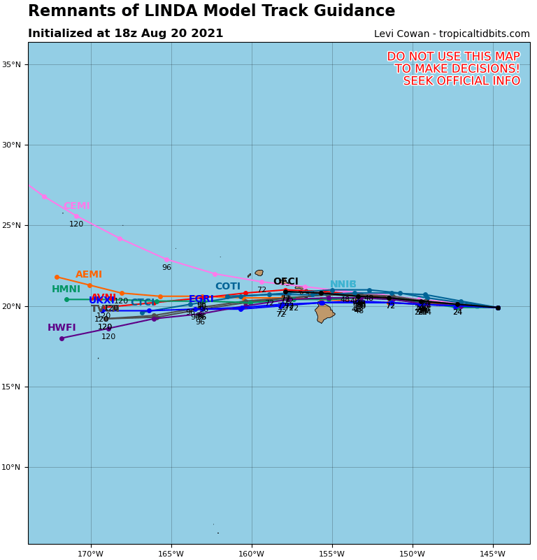
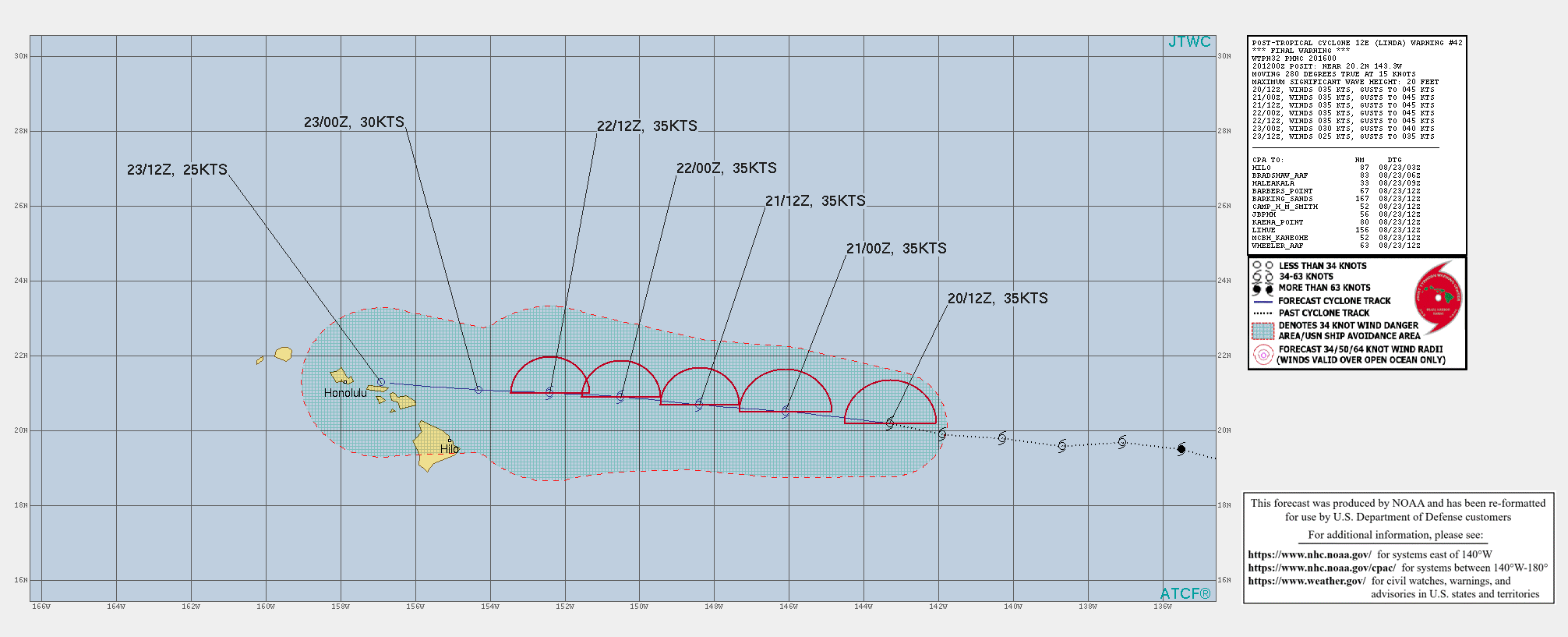
未來其殘餘將通過夏威夷群島,並在進入西太前徹底消散
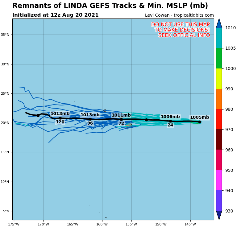
12E_gefs_latest (1).png 12E_tracks_latest.png
ep1221 (7).gif
WTPN32 PHNC 201600
MSGID/GENADMIN/JOINT TYPHOON WRNCEN PEARL HARBOR HI//
SUBJ/POST-TROPICAL CYCLONE 12E (LINDA) WARNING NR 042//
RMKS/
1. POST-TROPICAL CYCLONE 12E (LINDA) WARNING NR 042   
   01 ACTIVE TROPICAL CYCLONE IN EASTPAC
   MAX SUSTAINED WINDS BASED ON ONE-MINUTE AVERAGE
   WIND RADII VALID OVER OPEN WATER ONLY
    ---
   WARNING POSITION:
   201200Z --- NEAR 20.2N 143.3W
     MOVEMENT PAST SIX HOURS - 280 DEGREES AT 15 KTS
     POSITION ACCURATE TO WITHIN 020 NM
     POSITION BASED ON CENTER LOCATED BY SATELLITE
   PRESENT WIND DISTRIBUTION:
   MAX SUSTAINED WINDS - 035 KT, GUSTS 045 KT
   WIND RADII VALID OVER OPEN WATER ONLY
   RADIUS OF 034 KT WINDS - 070 NM NORTHEAST QUADRANT
                            000 NM SOUTHEAST QUADRANT
                            000 NM SOUTHWEST QUADRANT
                            070 NM NORTHWEST QUADRANT
   REPEAT POSIT: 20.2N 143.3W
    ---
   FORECASTS:
   12 HRS, VALID AT:
   210000Z --- 20.5N 146.1W
   MAX SUSTAINED WINDS - 035 KT, GUSTS 045 KT
   WIND RADII VALID OVER OPEN WATER ONLY
   POST-TROPICAL
   RADIUS OF 034 KT WINDS - 070 NM NORTHEAST QUADRANT
                            000 NM SOUTHEAST QUADRANT
                            000 NM SOUTHWEST QUADRANT
                            070 NM NORTHWEST QUADRANT
   VECTOR TO 24 HR POSIT: 275 DEG/ 11 KTS
    ---
   24 HRS, VALID AT:
   211200Z --- 20.7N 148.4W
   MAX SUSTAINED WINDS - 035 KT, GUSTS 045 KT
   WIND RADII VALID OVER OPEN WATER ONLY
   POST-TROPICAL
   RADIUS OF 034 KT WINDS - 060 NM NORTHEAST QUADRANT
                            000 NM SOUTHEAST QUADRANT
                            000 NM SOUTHWEST QUADRANT
                            060 NM NORTHWEST QUADRANT
   VECTOR TO 36 HR POSIT: 275 DEG/ 10 KTS
    ---
   36 HRS, VALID AT:
   220000Z --- 20.9N 150.5W
   MAX SUSTAINED WINDS - 035 KT, GUSTS 045 KT
   WIND RADII VALID OVER OPEN WATER ONLY
   POST-TROPICAL
   RADIUS OF 034 KT WINDS - 060 NM NORTHEAST QUADRANT
                            000 NM SOUTHEAST QUADRANT
                            000 NM SOUTHWEST QUADRANT
                            060 NM NORTHWEST QUADRANT
   VECTOR TO 48 HR POSIT: 275 DEG/ 09 KTS
    ---
   EXTENDED OUTLOOK:
   48 HRS, VALID AT:
   221200Z --- 21.0N 152.4W
   MAX SUSTAINED WINDS - 035 KT, GUSTS 045 KT
   WIND RADII VALID OVER OPEN WATER ONLY
   POST-TROPICAL
   RADIUS OF 034 KT WINDS - 060 NM NORTHEAST QUADRANT
                            000 NM SOUTHEAST QUADRANT
                            000 NM SOUTHWEST QUADRANT
                            060 NM NORTHWEST QUADRANT
   VECTOR TO 60 HR POSIT: 275 DEG/ 09 KTS
    ---
   60 HRS, VALID AT:
   230000Z --- 21.1N 154.3W
   MAX SUSTAINED WINDS - 030 KT, GUSTS 040 KT
   WIND RADII VALID OVER OPEN WATER ONLY
   POST-TROP/REMNT LOW
   VECTOR TO 72 HR POSIT: 275 DEG/ 12 KTS
    ---
   72 HRS, VALID AT:
   231200Z --- 21.3N 156.9W
   MAX SUSTAINED WINDS - 025 KT, GUSTS 035 KT
   WIND RADII VALID OVER OPEN WATER ONLY
   POST-TROP/REMNT LOW
    ---
REMARKS:
201600Z POSITION NEAR 20.3N 144.2W.
20AUG21. POST-TROPICAL CYCLONE 12E (LINDA), LOCATED APPROXIMATELY
666 NM EAST OF HILO, HAS TRACKED WESTWARD AT 15 KNOTS OVER THE PAST
SIX HOURS.THIS IS THE FINAL WARNING ON THIS SYSTEM BY THE JOINT
TYPHOON WRNCEN PEARL HARBOR HI. THE SYSTEM WILL BE CLOSELY MONITORED
FOR SIGNS OF REGENERATION. MAXIMUM SIGNIFICANT WAVE HEIGHT AT 201200Z
IS 20 FEET.
//
NNNN
回復

使用道具 舉報

簽到天數: 1650 天

[LV.Master]伴壇終老

老農民版夜神月|2021-8-22 00:12 | 顯示全部樓層
其實還是有一定環流的,感覺CPHC扔的早了

12E_BAND01.png 12E_RBTOP (2).gif
LATEST (42).jpg two_cpac_2d0.png

回復

使用道具 舉報

簽到天數: 1650 天

[LV.Master]伴壇終老

老農民版夜神月|2021-8-22 11:31 | 顯示全部樓層
然後Linda其實00Z又稍微重新增強到40節了
...不知道怎麼說,只能說CPHC這個機構真的是太懶了
12E LINDA 210822 0000 20.6N 149.7W EPAC 40 1004

20210822.0240.goes-17.vis.2km.12E.LINDA.40kts.1004mb.20.6N.149.7W.pc.jpg 20210821.2254.gw1.89pct89h89v.12E.LINDA.35kts.1006mb.20.2N.149W.69pc.jpg

20210821.1745.mta.ASCAT.wind.12E.LINDA.35kts-1006mb.202N.1490W.25km.noqc.jpeg
回復

使用道具 舉報

快速回覆
您需要登錄後才可以回帖 登錄 | 立即加入

本版積分規則

本平台僅供學術討論之用,預報應以氣象局為準

威普網站虛擬主機贊助公司

臺灣第一個天氣類型社群平台 即時天氣資訊、精準颱風動態

線上客服
FB傳送訊息
廣告行銷
精準行銷 物超所值
官方粉專
發佈 快速回復 返回頂部 返回列表