開啟輔助訪問
 找回密碼
 立即加入

10L.Kate 逐漸減弱

簽到天數: 1650 天

[LV.Master]伴壇終老

老農民版夜神月|2021-8-29 02:53 | 顯示全部樓層
本帖最後由 老農民版夜神月 於 2021-8-30 07:17 編輯

12Z的風場有大量30節左右旗幟,與NHC定強相符合
NHC應該是參考過風場
20210828.1157.mta.ASCAT.wind.10L.TEN.30kts-1007mb.145N.500W.25km.noqc.jpeg 10L_BAND01.gif 20210828.1623.gw1.89pct89h89v.10L.TEN.30kts.1007mb.14.5N.50W.70pc.jpg
20210828.1623.gw1.89hbt.10L.TEN.30kts.1007mb.14.5N.50W.70pc.jpg
回復

使用道具 舉報

簽到天數: 1650 天

[LV.Master]伴壇終老

老農民版夜神月|2021-8-31 02:09 | 顯示全部樓層
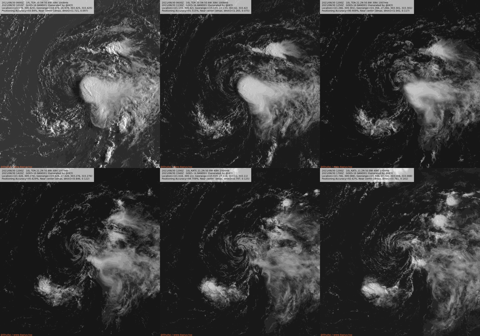
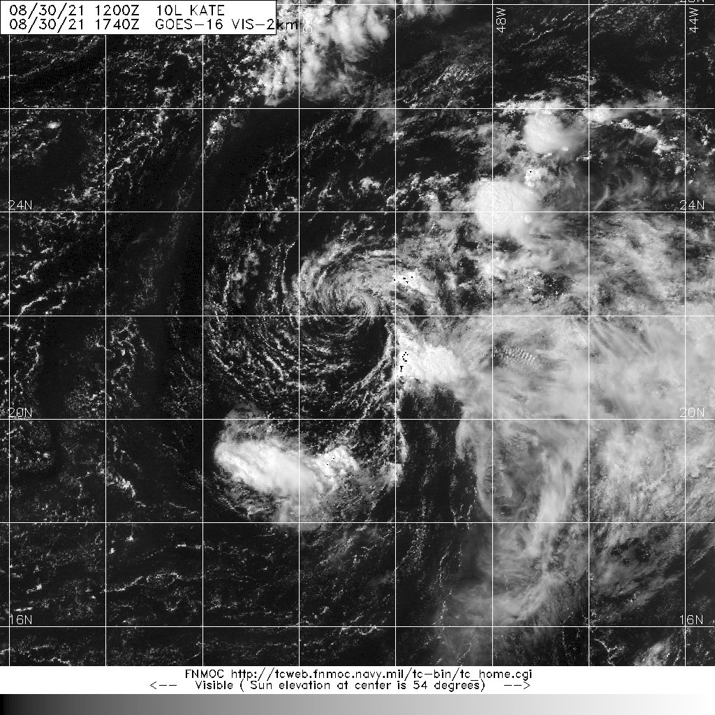
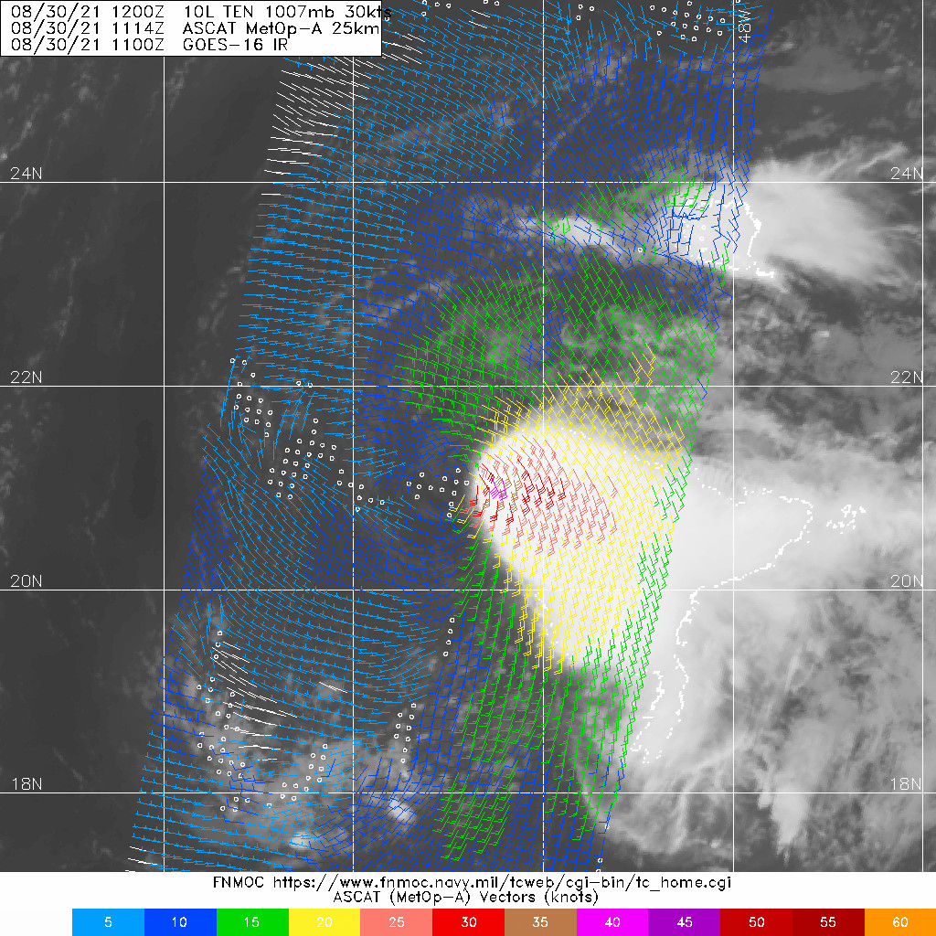
由於風場掃描達標,15Z命名Kate 20210830.1114.mta.ASCAT.wind.10L.TEN.30kts-1007mb.212N.508W.25km.noqc.jpeg
10L_BAND01 (1).gif 20210830.1740.goes-16.vis.2km.10L.KATE.40kts.1004mb.21.2N.50.8W.pc.jpg
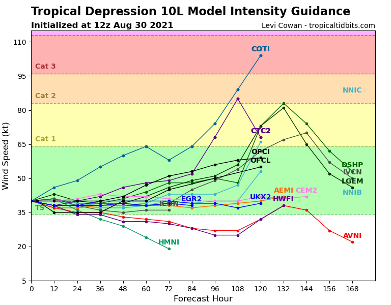
10L_intensity_latest.png

000
WTNT45 KNHC 301455
TCDAT5

Tropical Storm Kate Discussion Number  10
NWS National Hurricane Center Miami FL       AL102021
1100 AM AST Mon Aug 30 2021

Although strong upper-level westerly shear continues to plague the
cyclone, its satellite presentation improved early this morning as
its center moved closer to the edge of the convective cloud mass to
its east. An ASCAT-A pass from 1100 UTC revealed an area of 30 to
40-kt winds in the eastern semicircle of the cyclone, with some
slightly stronger winds possibly rain contaminated underneath the
deep convection. Additionally, UW-CIMSS ADT objective estimates have
risen to around 40 kt within the past few hours, and TAFB gave a
T2.5/35 kt subjective Dvorak classification at 12 UTC. These data
support upgrading the depression to Tropical Storm Kate. Its initial
intensity is set at 40 kt for this advisory, although that could be
a bit generous given recent satellite trends.

A weakness in the subtropical ridge is allowing Kate to move just
west of due north, or 355/7 kt. This general motion should continue
for the next day or so before the subtropical ridge becomes
reestablished over the central Atlantic Ocean. Thereafter, the
cyclone should move northwestward on Wednesday and Thursday along
the southwestern periphery of the ridge. By Friday, an approaching
deep-layer trough should cause the cyclone to accelerate northward
or north-northeastward through the rest of the forecast period. The
track guidance has shifted a little left of the previous NHC track,
and so the official forecast has been adjusted in that direction to
bring it closer to the TVCA and HCCA consensus aids.

The near-term intensity forecast is tricky, as the subtropical jet
stream will maintain strong west-northwesterly shear over Kate
during the next 24 to 36 h. In fact, recent satellite imagery of the
cyclone shows the center is already more exposed than earlier this
morning as the convection is waning. Kate is likely to continue
exhibiting a bursting convective pattern over the next couple of
days, which would likely result in some intensity fluctuations that
hover around the tropical-storm-force threshold. The official NHC
intensity forecast shows Kate as a 35-kt tropical storm during the
first 36 h of the forecast. If Kate survives the hostile shear
conditions, some modest intensification will be possible while the
cyclone remains over 28 deg C waters. However, Kate will encounter a
drier mid-level environment as it gains latitude, so significant
strengthening does not appear likely at this time. The official
intensity forecast is similar to the previous one beyond 48 h, as it
shows only modest strengthening with time. By day 5, the global
models suggest that Kate could be becoming absorbed by a larger
extratropical low expected to form and deepen near Atlantic Canada.


FORECAST POSITIONS AND MAX WINDS

INIT  30/1500Z 21.5N  50.9W   40 KT  45 MPH
12H  31/0000Z 22.3N  50.7W   35 KT  40 MPH
24H  31/1200Z 23.3N  50.5W   35 KT  40 MPH
36H  01/0000Z 24.3N  50.6W   35 KT  40 MPH
48H  01/1200Z 25.5N  51.5W   40 KT  45 MPH
60H  02/0000Z 26.9N  52.7W   40 KT  45 MPH
72H  02/1200Z 28.4N  54.2W   45 KT  50 MPH
96H  03/1200Z 32.0N  55.5W   50 KT  60 MPH
120H  04/1200Z 37.0N  53.4W   55 KT  65 MPH

$$
Forecaster Reinhart

回復

使用道具 舉報

簽到天數: 1650 天

[LV.Master]伴壇終老

老農民版夜神月|2021-9-1 00:49 | 顯示全部樓層
NHC降格TD,且不再預測後續能夠再撐強 144643_5day_cone_no_line_and_wind.png 10L_gefs_latest.png
20210831.1620.goes-16.vis.2km.10L.KATE.30kts.1007mb.23.2N.50.7W.pc.jpg 20210831.1155.gpm.89pct89h89v.10L.KATE.35kts.1006mb.22.8N.50.9W.055pc.jpg

FORECAST POSITIONS AND MAX WINDS

INIT  31/1500Z 23.5N  50.8W   30 KT  35 MPH
12H  01/0000Z 24.3N  51.0W   30 KT  35 MPH
24H  01/1200Z 25.7N  51.7W   30 KT  35 MPH
36H  02/0000Z 27.3N  52.7W   30 KT  35 MPH
48H  02/1200Z 29.0N  53.6W   30 KT  35 MPH
60H  03/0000Z 30.7N  54.1W   30 KT  35 MPH
72H  03/1200Z 32.5N  53.9W   30 KT  35 MPH
96H  04/1200Z...DISSIPATED

回復

使用道具 舉報

簽到天數: 1650 天

[LV.Master]伴壇終老

老農民版夜神月|2021-9-1 12:24 | 顯示全部樓層
發展不如預期,預估在36H內將消散 023409_5day_cone_no_line_and_wind.png 20210901.0400.goes-16.ir.10L.KATE.25kts.1009mb.25N.51.1W.100pc.jpg
LATEST (50).jpg

000
WTNT45 KNHC 010233
TCDAT5

Tropical Depression Kate Discussion Number  16
NWS National Hurricane Center Miami FL       AL102021
1100 PM AST Tue Aug 31 2021

Some bursts of convection have been forming within Kate's small
circulation during the past several hours, but none of it has any
real significant organization.  In addition, the low clouds appear
to be losing definition, and a very-recent ASCAT-B pass showed that
the maximum winds are now only about 25 kt.  It's going to be
difficult for Kate to make much of a comeback, if at all.  Moderate
northerly shear, dry mid-level air, upper-level convergence, and an
increasingly anticyclonic low-level environment are likely to cause
the circulation to spin down further and make it hard for deep
convection to persist.  Therefore, the NHC official forecast now
calls for additional weakening, with Kate likely becoming a remnant
low by 36 hours (if not sooner) and dissipating by 72 hours.  This
scenario is closest to the GFS, HWRF, and HMON solutions.

Located on the southwestern periphery of a low-level area of high
pressure, Kate is moving toward the north-northwest (345/9 kt).
The depression is forecast to turn toward the northwest by morning,
but then recurve around the high toward the north and
north-northeast in a couple of days.  The NHC track forecast remains
close to the consensus aids and is generally just an update from the
previous advisory.


FORECAST POSITIONS AND MAX WINDS

INIT  01/0300Z 25.4N  51.3W   25 KT  30 MPH
12H  01/1200Z 26.4N  52.1W   25 KT  30 MPH
24H  02/0000Z 27.9N  53.1W   25 KT  30 MPH
36H  02/1200Z 29.8N  53.8W   20 KT  25 MPH...POST-TROP/REMNT LOW
48H  03/0000Z 31.6N  54.1W   20 KT  25 MPH...POST-TROP/REMNT LOW
60H  03/1200Z 33.1N  53.7W   20 KT  25 MPH...POST-TROP/REMNT LOW
72H  04/0000Z...DISSIPATED

$$
Forecaster Berg
回復

使用道具 舉報

簽到天數: 1650 天

[LV.Master]伴壇終老

老農民版夜神月|2021-9-2 05:40 | 顯示全部樓層
21Z判定已減弱為殘餘低氣壓 204141_5day_cone_no_line_and_wind (1).png 20212442020_GOES16-ABI-FL-GEOCOLOR-AL102021-1000x1000.jpg
20210901.1211.mta.ASCAT.wind.10L.KATE.30kts-1007mb.266N.523W.25km.jpg

000
WTNT45 KNHC 012042
TCDAT5

Remnants Of Kate Discussion Number  19
NWS National Hurricane Center Miami FL       AL102021
500 PM AST Wed Sep 01 2021

Kate's structure this afternoon has deteriorated further. While
occasional bursts of deep convection are still occuring to the south
of a broad area of low-level cyclonic rotation, this activity lacks
much organization. Recent visible satellite imagery also suggests
that the low-level circulation is in the process of opening up into
a trough, with little if any northerly cloud motions being observed
to the west of the estimated center. In addition, I have been
fortunate to receive some in-situ data from the NASA-DC8 aircraft
that earlier preformed a research mission into Kate. Dropsonde data
launched near the center indicated that the surface pressure was
near 1012 mb, which is only a few millibars lower than the
environmental ambient pressure. The dropsondes launched west of the
center also failed to find any northerly surface winds. The
combination of these data suggest that Kate's center is losing
definition and no longer possesses a well-defined circulation.
Therefore, the system no longer meets the definition of a tropical
cyclone, and this will be the final advisory. Maximum sustained
winds have also been lowered to 25-kt based on the surface winds
from dropsonde data provided by the DC8 aircraft to the east of the
center.

The remnants of Kate have accelerated to the north-northwest today
with the estimated motion at 340/13 kt, likely as the low-level
vorticity maxima has become fully decoupled from the mid-level
vortex located well to the south and east. This motion should
continue until Kate completely fades away while embedded in
the synoptic environment near a low-level subtropical ridge.


FORECAST POSITIONS AND MAX WINDS

INIT  01/2100Z 28.5N  52.9W   25 KT  30 MPH
12H  02/0600Z...DISSIPATED

$$
Forecaster Papin
回復

使用道具 舉報

12
快速回覆
您需要登錄後才可以回帖 登錄 | 立即加入

本版積分規則

本平台僅供學術討論之用,預報應以氣象局為準

威普網站虛擬主機贊助公司

臺灣第一個天氣類型社群平台 即時天氣資訊、精準颱風動態

線上客服
FB傳送訊息
廣告行銷
精準行銷 物超所值
官方粉專
發佈 快速回復 返回頂部 返回列表