開啟輔助訪問
 找回密碼
 立即加入

12L.Larry 巔峰曾達C3 遠洋無害

簽到天數: 1650 天

[LV.Master]伴壇終老

2021-8-31 02:40 | 顯示全部樓層
  三級颶風  
編號:12 L
名稱:Larry
20210906.0300.goes-16.ir.12L.LARRY.110kts.955mb.20.7N.51W.100pc.jpg
  基本資料  
擾動編號日期:2021 08 31 02
命名日期  :2021 09 01 17
撤編日期  :2021 09 11 20
登陸地點  :


  巔峰時期資料  
近中心最強風速 :110  kt (
Cat.3 )
海平面最低氣壓 :958 百帕

  擾動編號資料  

90L.INVEST.25kts.1007mb.8.7N.15.3W
20210830.1800.goes-16.ir.90L.INVEST.25kts.1007mb.8.7N.15.3W.100pc.jpg

  NHC:70%
1. Satellite-derived wind data and satellite imagery indicate that an
area of low pressure has formed over the far eastern Tropical
Atlantic in association with a tropical wave that recently moved off
the west coast of Africa.  Environmental conditions are conducive
for development, and a tropical depression is likely to form within
the next couple of days while the system moves west-northwestward at
10 to 15 mph over the eastern tropical Atlantic.
* Formation chance through 48 hours...high...70 percent.
* Formation chance through 5 days...high...90 percent.

two_atl_2d1 (35).png two_atl_5d1 (36).png 以上資料來自:NHC、颱風論壇整理製作

評分

參與人數 1水氣能量 +15 +1 收起 理由
t02436 + 15 + 1

查看全部評分

回復

使用道具 舉報

簽到天數: 1650 天

[LV.Master]伴壇終老

老農民版夜神月|2021-8-31 05:45 | 顯示全部樓層
數值看好後期強度發展
natl (3).png 90L_gefs_latest (2).png
90L_intensity_latest.png
回復

使用道具 舉報

簽到天數: 1650 天

[LV.Master]伴壇終老

老農民版夜神月|2021-8-31 14:00 | 顯示全部樓層
NHC展望已提升至90%
1. A well-defined low pressure system is located over the far eastern
tropical Atlantic more than 200 miles southwest of the coast of
Guinea.  Associated shower and thunderstorm activity is beginning
to show some signs of organization, and environmental conditions
are conducive for additional development of this system. A tropical
depression is likely to form during the next day or so while the
low moves westward to west-northwestward at 10 to 15 mph.
* Formation chance through 48 hours...high..90 percent.
* Formation chance through 5 days...high...90 percent.
two_atl_2d1 (4).png two_atl_5d1 (4).png
natl (2).png 90L_gefs_latest (1).png
回復

使用道具 舉報

簽到天數: 1650 天

[LV.Master]伴壇終老

老農民版夜神月|2021-8-31 20:54 | 顯示全部樓層
FWC-N發布TCFA
WTNT21 KNGU 311300
SUBJ/TROPICAL CYCLONE FORMATION ALERT //
RMKS/1.FORMATION OF A SIGNIFICANT TROPICAL CYCLONE IS POSSIBLE WITHIN
100 NM EITHER SIDE OF A LINE FROM 9.0N 16.9W TO 10.0N 21.0W
WITHIN THE NEXT 24 HOURS. AVAILABLE DATA DOES NOT JUSTIFY
ISSUANCE OF NUMBERED TROPICAL CYCLONE WARNINGS AT THIS TIME.
WINDS IN THE AREA ARE ESTIMATED TO BE 30 TO 40 KNOTS. METSAT
IMAGERY AT 311200Z INDICATES THAT A CIRCULATION CENTER IS LOCATED
NEAR 9.0N 16.9W. THE SYSTEM IS MOVING WEST-NORTHWESTWARD AT 10
KNOTS.
2.REMARKS: SHOWERS AND THUNDERSTORMS CONTINUE TO SHOW SIGNS OF ORGANIZATION
IN ASSOCIATION WITH AN AREA OF LOW PRESSURE A FEW HUNDRED MILES
SOUTHEAST OF THE CABO VERDE ISLANDS. IN ADDITION, THE SURFACE
CIRCULATION HAS BECOME BETTER DEFINED OVERNIGHT. ENVIORNMENTAL
CONDITIONS ARE CONDUCIVE FOR FURTHER DEVELOPMENT, AND ONLY A
SLIGHT INCREASE IN ORGANIZATION WOULD RESULT IN THE FORECAST TO
MOVE GENERALLY WEST-NORTHWESTWARD OVER THE EASTERN TROPICAL
ATLANTIC DURING THE NEXT SEVERAL DAYS.
3. THIS ALERT WILL BE REISSUED, UPGRADED TO WARNING OR CANCELLED BY 011300Z.
//
al902021 (1).gif two_atl_2d1 (5).png
回復

使用道具 舉報

簽到天數: 1650 天

[LV.Master]伴壇終老

老農民版夜神月|2021-9-1 04:22 | 顯示全部樓層
本帖最後由 老農民版夜神月 於 2021-9-1 04:23 編輯

NHC升格12L
AL122021 - Tropical Depression TWELVE

LATEST (49).jpg 20210831.1940.goes-16.ir.90L.INVEST.30kts.1006mb.10.8N.20.2W.100pc.jpg
20210831.1942.f17.91pct91h91v.90L.INVEST.30kts.1006mb.10.8N.20.2W.095pc.jpg
回復

使用道具 舉報

簽到天數: 1650 天

[LV.Master]伴壇終老

老農民版夜神月|2021-9-1 04:44 | 顯示全部樓層
初報上望90節不封頂
142
WTNT42 KNHC 312035
TCDAT2

Tropical Depression Twelve Discussion Number   1
NWS National Hurricane Center Miami FL       AL122021
800 PM CVT Tue Aug 31 2021

Satellite imagery, along with earlier scatterometer data, indicates
that the low pressure area over the eastern tropical Atlantic has
a well-defined circulation and sufficient organized convection to
be considered a tropical depression.  Thus, advisories are being
initiated on Tropical Depression Twelve.  The initial intensity is
set at 30 kt based on satellite intensity estimates from TAFB and
SAB as well as the scatterometer data.

The initial motion is a somewhat uncertain 285/14.  A strong low-
to mid-level ridge to the north should cause the cyclone to move
westward at a faster forward speed for the next 36 h or so,
followed by a gradual turn toward the west-northwest and northwest
by the end of the period as the depression moves along the
southwest side of the ridge.  There is some spread in the guidance
after 36-48 h, with the GFS and GFS ensemble mean showing a more
northward motion while the UKMET and the UKMET ensemble mean show a
more westward motion.  The official forecast is near the middle of
the guidance envelope and is close to the HFIP corrected consensus
model, which is a little to the south of the other consensus models.

Conditions appear favorable for intensification during the next 72
h or so as the cyclone is in a moist environment with light shear
and warm sea surface temperatures.  The intensity forecast thus
calls for the cyclone to become a tropical storm in 12 h or so and
reach hurricane strength in 48-60 h.  By the end of the forecast
period, the forecast track takes the cyclone over slightly cooler
water and into a drier air mass.  Based on this, the intensity
forecast calls for a slower development rate.  The official
intensity forecast is in the middle of the intensity guidance, and
it is possibly conservative given that many of the global models
are showing the development of a large and powerful tropical
cyclone.

FORECAST POSITIONS AND MAX WINDS

INIT  31/2100Z 11.2N  21.1W   30 KT  35 MPH
12H  01/0600Z 11.6N  23.9W   35 KT  40 MPH
24H  01/1800Z 12.0N  27.5W   40 KT  45 MPH
36H  02/0600Z 12.1N  30.7W   50 KT  60 MPH
48H  02/1800Z 12.5N  33.7W   60 KT  70 MPH
60H  03/0600Z 13.3N  36.5W   70 KT  80 MPH
72H  03/1800Z 14.3N  39.0W   80 KT  90 MPH
96H  04/1800Z 16.5N  43.5W   85 KT 100 MPH
120H  05/1800Z 19.5N  47.5W   90 KT 105 MPH

$$
Forecaster Beven
203624_5day_cone_no_line_and_wind.png 90L_intensity_latest (1).png

natl (4).png
回復

使用道具 舉報

簽到天數: 1650 天

[LV.Master]伴壇終老

老農民版夜神月|2021-9-1 17:34 | 顯示全部樓層
本帖最後由 老農民版夜神月 於 2021-9-1 19:35 編輯

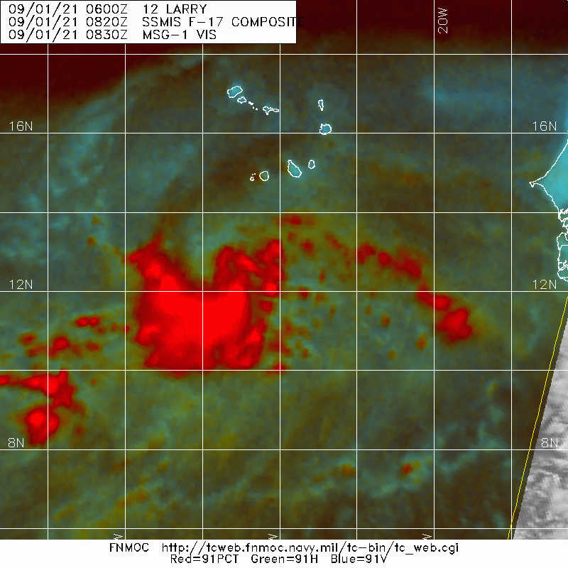
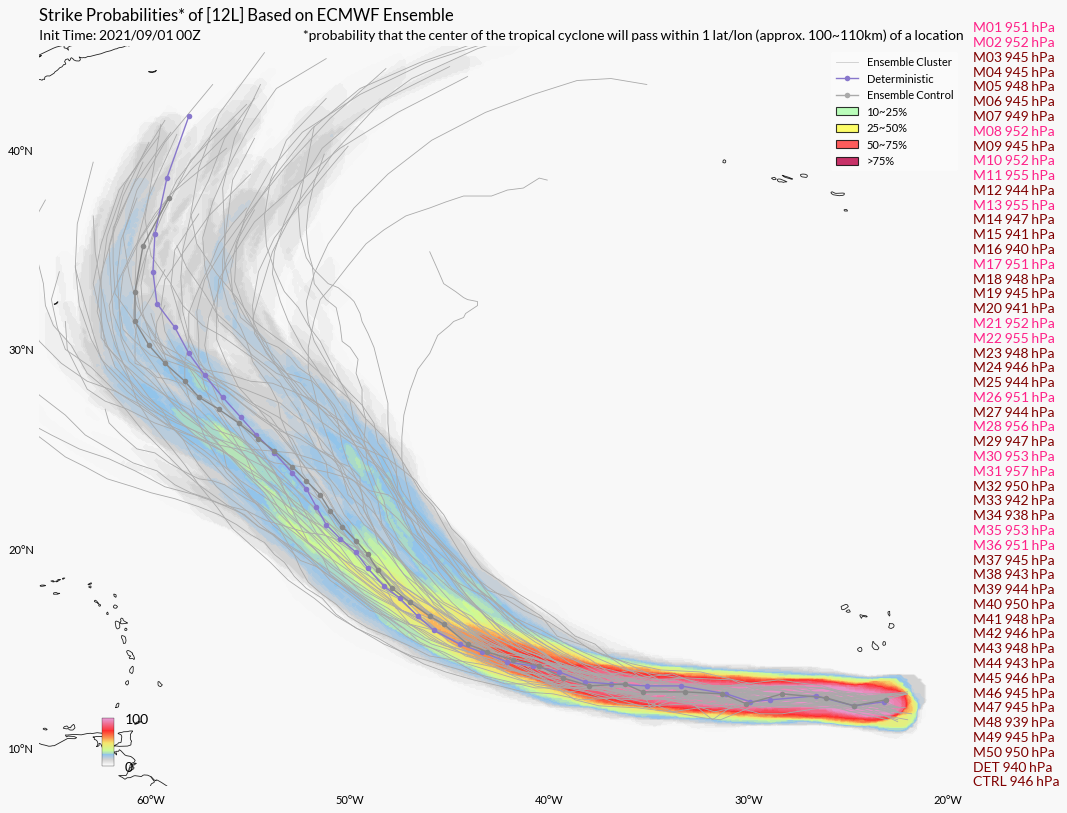
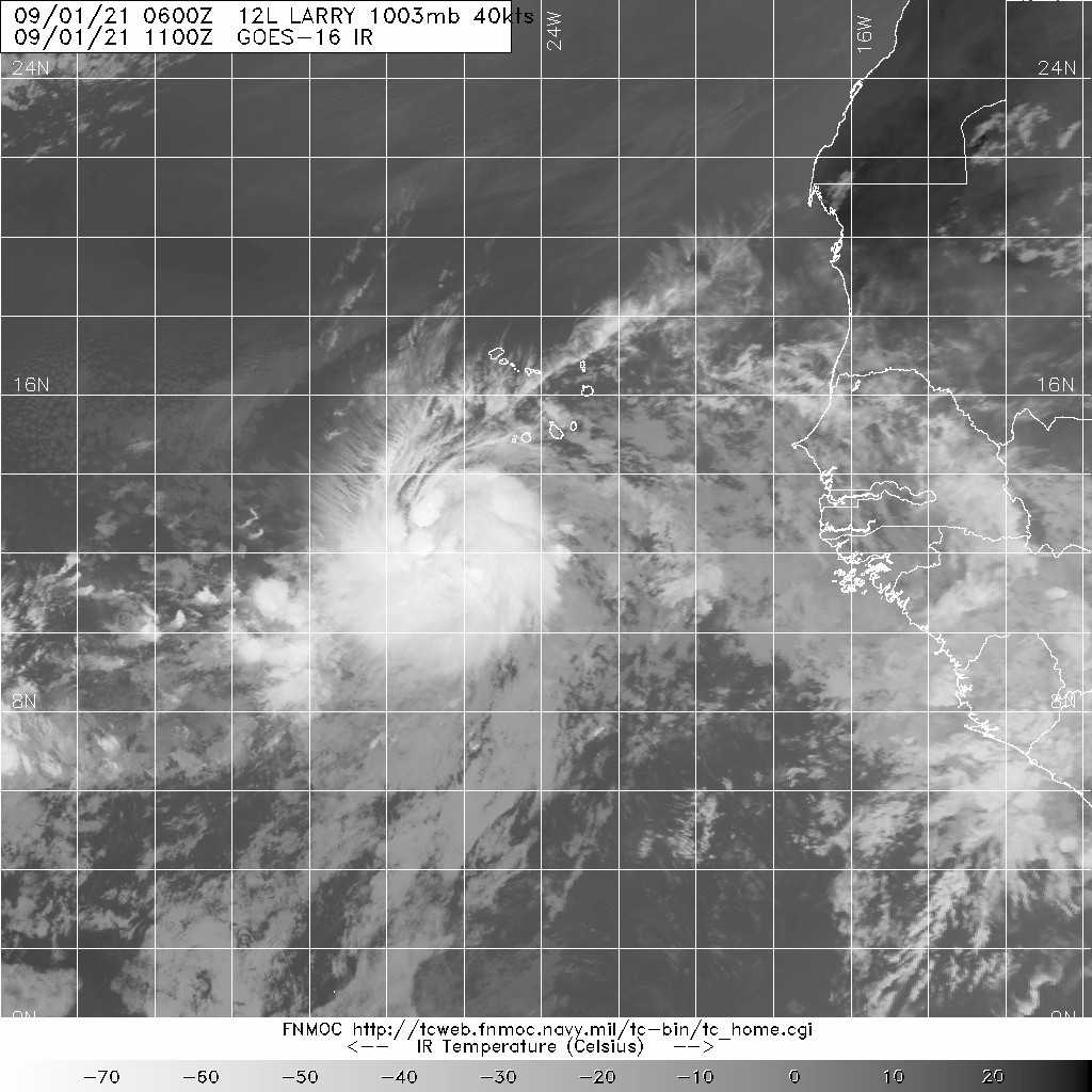
09Z命名Larry 20210901.1100.goes-16.ir.12L.LARRY.40kts.1003mb.12.2N.23.9W.100pc.jpg 20210901.0820.f17.91pct91h91v.12L.LARRY.40kts.1003mb.12.2N.23.9W.100pc.jpg 12L.png
042
WTNT42 KNHC 010858
TCDAT2

Tropical Storm Larry Discussion Number   3
NWS National Hurricane Center Miami FL       AL122021
800 AM CVT Wed Sep 01 2021

Deep convection with cloud tops colder than -80C have increased over
and to the west of the low-level center since the previous advisory.
Subjective satellite intensity estimates at 0600 UTC from TAFB and
SAB were T2.5/35 kt and T3.0/45 kt, while the most recent objective
intensity estimates from UW-CIMSS are T2.8/41 kt from ADT and 37 kt
from SATCON. An average of these intensity estimates support
increasing the advisory intensity to 40 kt, making the cyclone
Tropical Storm Larry. In addition, 0300 UTC and 0700 UTC
observations from ship VRNF3, which recently passed through the
center of Larry, reported a pressure of 1006.8 mb and winds near 25
kt. These data were the basis for the estimated central pressure of
1003 mb, a pressure value that also supports an intensity of 40 kt.

Larry has turned more westward over the past several hours, and the
new motion estimate is 280/17 kt. Larry is expected to move around
the southern and southwestern periphery of the sprawling
Bermuda-Azores ridge for the next 5 days, resulting in a general
west motion for the next 36 hours or so, followed by a turn toward
the west-northwest on Friday, and a northwestward motion over the
weekend and continuing into early next week. There has been a
pronounced westward shift in the track guidance for this cycle, with
the greatest shift coming from the GFS model. Over the past 36
hours, the GFS has shifted its track westward by more than 500 nmi,
and even the latest shift still keeps the GFS model the easternmost
track forecast in the guidance suite. In contrast, the ECMWF and
UKMET models, which lie along the westernmost portion of the
guidance envelope, have been fairly stable. Owing to the westward
shift in the overall guidance envelope, and considering the GFS
solution as an outlier model, the new NHC forecast track has also
been shifted westward, and lies between the NOAA-HCCA
corrected-consensus model to the south, and the tightly packed TVCA
simple-consensus model and FSSE corrected-consensus model to the
north. Given the poor handling of the ridge to the north of Larry by
the GFS, subsequent NHC forecast tracks may have to be shifted
farther west.

Given the improved inner-core wind field based on earlier ASCAT wind
data and reports from ship VRNF3, along with warm sea-surface
temperatures of 28 deg C and light easterly to southeasterly
vertical shear of around 5 kt, steady strengthening is expected for
the next 24 hours or so. By 36 hours when Larry is expected to be a
hurricane and have a well-established and tighter inner-core wind
field and possibly an eye, rapid intensification is forecast, with
Larry becoming a major hurricane by 72 hour. This in large part due
to the massive equatorward upper-level outflow pattern that all
of the global and regional models are forecasting, which is the
same type of outflow pattern that recently occurred with Hurricane
Ida. The new official intensity forecast is above the previous
advisory forecast by about 10 kt at all forecast times, and
conservatively follows an average of the Decay-SHIPS, COAMPS-TC,
FSSE, and ECMWF models. This intensity forecast is near the upper
end of the guidance envelope and is above the other consensus
intensity models.


FORECAST POSITIONS AND MAX WINDS

INIT  01/0900Z 12.3N  24.8W   40 KT  45 MPH
12H  01/1800Z 12.5N  27.5W   50 KT  60 MPH
24H  02/0600Z 12.6N  30.6W   60 KT  70 MPH
36H  02/1800Z 13.1N  33.7W   70 KT  80 MPH
48H  03/0600Z 13.6N  36.8W   85 KT 100 MPH
60H  03/1800Z 14.4N  39.7W   95 KT 110 MPH
72H  04/0600Z 15.5N  42.0W  100 KT 115 MPH
96H  05/0600Z 18.2N  46.9W  105 KT 120 MPH
120H  06/0600Z 21.3N  50.6W  105 KT 120 MPH

$$
Forecaster Stewart

回復

使用道具 舉報

簽到天數: 1650 天

[LV.Master]伴壇終老

老農民版夜神月|2021-9-2 05:43 | 顯示全部樓層
已增強至TS上限60KT,即將升格C1 20212442120_GOES16-ABI-FL-07-AL122021-1000x1000.jpg 20210901.2055.gpm.89hbt.12L.LARRY.55kts.994mb.12.4N.28.4W.060pc.jpg

20210901.2055.gpm.89pct89h89v.12L.LARRY.55kts.994mb.12.4N.28.4W.060pc.jpg 20210901.1150.mtb.ASCAT.wind.12L.LARRY.40kts-1003mb.124N.260W.25km.noqc.jpg

FORECAST POSITIONS AND MAX WINDS

INIT  01/2100Z 12.5N  29.4W   60 KT  70 MPH
12H  02/0600Z 12.6N  31.8W   70 KT  80 MPH
24H  02/1800Z 13.0N  34.9W   85 KT 100 MPH
36H  03/0600Z 13.7N  38.0W   95 KT 110 MPH
48H  03/1800Z 14.6N  40.9W  100 KT 115 MPH
60H  04/0600Z 15.6N  43.5W  105 KT 120 MPH
72H  04/1800Z 16.9N  46.2W  105 KT 120 MPH
96H  05/1800Z 19.5N  50.5W  105 KT 120 MPH
120H  06/1800Z 22.5N  54.0W  105 KT 120 MPH
203843_5day_cone_no_line_and_wind.png
回復

使用道具 舉報

123下一頁
快速回覆
您需要登錄後才可以回帖 登錄 | 立即加入

本版積分規則

本平台僅供學術討論之用,預報應以氣象局為準

威普網站虛擬主機贊助公司

臺灣第一個天氣類型社群平台 即時天氣資訊、精準颱風動態

線上客服
FB傳送訊息
廣告行銷
精準行銷 物超所值
官方粉專
發佈 快速回復 返回頂部 返回列表