開啟輔助訪問
 找回密碼
 立即加入

11P.Dovi 轉化溫氣 侵襲紐西蘭北島

簽到天數: 483 天

[LV.9]以壇為家II

2022-2-5 09:41 | 顯示全部樓層
本帖最後由 周子堯@FB 於 2022-2-12 15:00 編輯

  基本資料  
編號               :92 P
擾動編號日期 :2022 02 05 09
撤編日期        :2022 02 00 00
92P INVEST 220204 1800 17.8S 152.1E SHEM 25 999
A15EC312-EC67-43C2-BFAE-63F636679333.jpeg

評分

參與人數 1水氣能量 +15 +1 收起 理由
t02436 + 15 + 1

查看全部評分

回復

使用道具 舉報

簽到天數: 2097 天

[LV.Master]伴壇終老

周子堯@FB|2022-2-6 22:26 | 顯示全部樓層
JTWC評級Low
(1) THE AREA OF CONVECTION (INVEST 92P) PREVIOUSLY LOCATED
NEAR 17.7S 153.2E IS NOW LOCATED NEAR 18.4S 160.0E, APPROXIMATELY
480NM WEST OF PORT VILA, VANUATU. ANIMATED MULTISPECTRAL SATELLITE
IMAGERY CONTINUES TO DEPICT A POORLY-ORGANIZED AND ELONGATED
DISTURBANCE EMBEDDED WITHIN A WEST-NORTHWEST TO EAST-SOUTHEAST
ORIENTED FRONTAL TROUGH. A 060252Z AMSR2 36GHZ COLOR COMPOSITE
MICROWAVE IMAGE REVEALS NO DISCERNIBLE LOW-LEVEL CIRCULATION WITH
HIGHLY DISORGANIZED SHALLOW BANDS OF CONVECTION ACROSS THE CORAL
SEA. THE DISTURBANCE IS LOCATED WITHIN MODERATE NORTHWESTERLY FLOW
ALONG THE SOUTHWESTERN PERIPHERY OF AN UPPER-LEVEL RIDGE. VERTICAL
WIND SHEAR REMAINS LOW TO MODERATE WITH WARM SEA SURFACE
TEMPERATURES OF 29-30 DEGREES CELSIUS. THE DISTURBANCE IS EXPECTED
TO TRACK EAST-SOUTHEASTWARD TOWARD VANUATU ALONG THIS FRONTAL
BOUNDARY FOR THE NEXT 12 HOURS WITHIN A MARGINALLY FAVORABLE
ENVIRONMENT. WITHIN THE NEXT 12 TO 24 HOURS, NUMERICAL MODELS
GENERALLY AGREE THAT SOME DEVELOPMENT WILL OCCUR AS THE DISTURBANCE
TRACKS UNDER A MORE FAVORABLE UPPER-LEVEL ENVIRONMENT BENEATH THE
BROAD UPPER-LEVEL RIDGE. THIS ZONE WILL BE MONITORED CLOSELY, AS A
COMPLEX ENVIRONMENT COULD LEAD TO MULTIPLE CIRCULATIONS FORMING IN
CLOSE PROXIMITY WITHIN THE SOUTH PACIFIC CONVERGENCE ZONE IN THE
GENERAL VICINITY OF NEW CALEDONIA, VANUATU, FIJI, AND TONGA DURING
THE NEXT SEVERAL DAYS. MAXIMUM SUSTAINED SURFACE WINDS ARE ESTIMATED
AT 20 TO 25 KNOTS. MINIMUM SEA LEVEL PRESSURE IS ESTIMATED TO BE
NEAR 999 MB. THE POTENTIAL FOR THE DEVELOPMENT OF A SIGNIFICANT
TROPICAL CYCLONE WITHIN THE NEXT 24 HOURS REMAINS LOW.
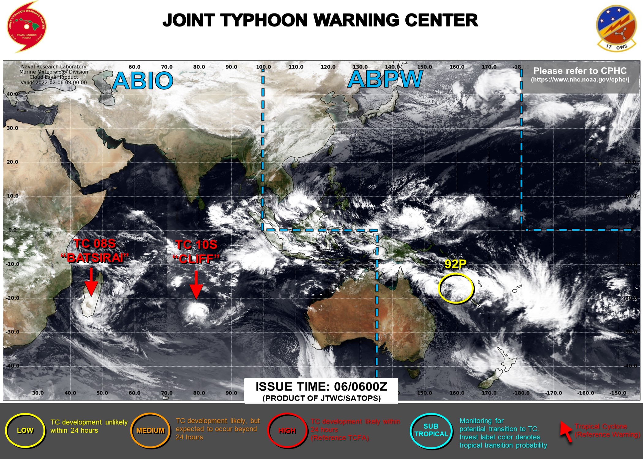
abpwsair (1).jpg
回復

使用道具 舉報

簽到天數: 2097 天

[LV.Master]伴壇終老

周子堯@FB|2022-2-6 22:31 | 顯示全部樓層
另外,編號為18U,部分模式看好發展成旋;或與未來東南側新發擾動互動
IDQ10810

Tropical Cyclone Outlook for Coral Sea
Issued at 2:53 pm EST on Saturday 5 February 2022
for the period until midnight EST Tuesday 8 February 2022.

Existing Cyclones in the Eastern Region:
Nil.

Potential Cyclones:

A tropical low, 18U, lies around 17.7S 154.2E at 13:00 pm AEST and was moving east at 10 knots. The environment is generally unfavourable for development, and the system only has a Low risk of reaching tropical cyclone intensity. 18U will move east ou of the region during Sunday. 18U will not affect the Australian mainland.

There are no other significant system expected in the next few days.

Likelihood of a tropical cyclone in the Eastern Region on:
Sunday:Low
Monday:Very Low
Tuesday:Very Low


NOTES: The likelihood is an estimate of the chance of each system being a tropical cyclone in the Region for each day.
Very Low:less than 5%Low:5% to 20%
Moderate:20 to 50%High:Over 50%
The area of coverage for this outlook is the Coral Sea and northern Tasman Sea west of 160E.
aus (1).png
IDQ10810

Tropical Cyclone Outlook for Coral Sea
Issued at 2:38 pm EST on Sunday 6 February 2022
for the period until midnight EST Tuesday 8 February 2022.

Existing Cyclones in the Eastern Region:
Nil.

Potential Cyclones:

Weak tropical low, 18U, lies around 18S 158E at 13:00 pm AEST Sunday and is moving east. The system has weakened overnight and will move east out of the region during Sunday. 18U will not reach tropical cyclone intensity in the region.

There are no other significant system expected in the next few days.


Likelihood of a tropical cyclone in the Eastern Region on:
Sunday:Very Low
Monday:Very Low
Tuesday:Very Low
20220206.1400.himawari-8.ir.92P.INVEST.20kts.1003mb.19.6S.163.3E.100pc.jpg

回復

使用道具 舉報

簽到天數: 2097 天

[LV.Master]伴壇終老

周子堯@FB|2022-2-12 14:59 | 顯示全部樓層
轉變溫氣,趨向紐國
Current status of cyclone activity
Cyclone Dovi was reclassified as an extra tropical low on Saturday afternoon but remains a significant weather system. At 1pm Saturday it was located near 33.5S 166.4E, about 600km west-northwest of Cape Reinga.

Forecast to 1am Mon, 14 Feb (NZT)
Cyclone Dovi was reclassified as an extra tropical low on Saturday afternoon. It should track southeast today while remaining a deep low, then move east across the central North Island during Sunday. Severe weather is expected for large parts of central and northern New Zealand, including areas well away from the low pressure centre. People are advised to keep up to date with latest severe weather watches and warnings from MetService.

No other significant lows expected.

Outlook to 1am Thu, 17 Feb (NZT)
No tropical cyclones are expected.

f4290-17eec844b00-17eecaabec0-17eef3decc0-17eecaabec0.png
758b-17eeb3ab400-17eeb3ab400-17eeb3ab400-17eeba2b8d5.png
回復

使用道具 舉報

快速回覆
您需要登錄後才可以回帖 登錄 | 立即加入

本版積分規則

本平台僅供學術討論之用,預報應以氣象局為準

威普網站虛擬主機贊助公司

臺灣第一個天氣類型社群平台 即時天氣資訊、精準颱風動態

線上客服
FB傳送訊息
廣告行銷
精準行銷 物超所值
官方粉專
發佈 快速回復 返回頂部 返回列表