|
|
 krichard2011|2023-4-14 00:24
|
顯示全部樓層
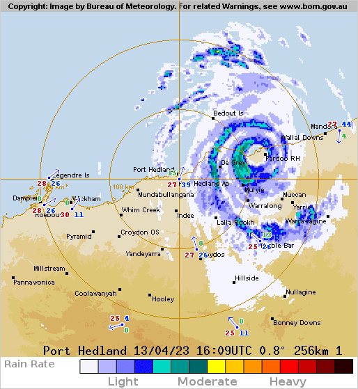
ILSA稍早登陸De Grey 與 Pardoo 之間

Details of Severe Tropical Cyclone Ilsa at 12:00 am AWST:
Intensity: Category 5, sustained winds near the centre of 215 kilometres per hour with wind gusts to 295 kilometres per hour.
Location: within 20 kilometres of 19.9 degrees South 119.6 degrees East, estimated to be 115 kilometres east northeast of Port Hedland and 30 kilometres northwest of Pardoo Roadhouse.
Movement: southeast at 18 kilometres per hour.
Severe Tropical Cyclone Ilsa, category 5, is crossing the coast between De Grey and Pardoo Roadhouse.
Observations at Bedout Island, offshore of the east Pilbara coast, recorded severe tropical cyclone winds of 218 km/h with gusts of 288 km/h.
A very destructive wind impact is occurring along the coast and adjacent inland parts between De Grey and Pardoo Roadhouse.
During Friday, Ilsa is forecast to maintain tropical cyclone intensity as it tracks past Telfer and further inland across the Northern Interior district and the northern parts of the Southern Interior district. Ilsa is then expected to weaken below tropical cyclone strength overnight Friday as it moves into southern parts of the Northern Territory.
補12Z 報文 - IDW27600
- TROPICAL CYCLONE TECHNICAL BULLETIN: AUSTRALIA - WESTERN REGION
- Issued by AUSTRALIAN BUREAU OF METEOROLOGY TROPICAL CYCLONE WARNING CENTRE
- at: 1241 UTC 13/04/2023
- Name: Severe Tropical Cyclone Ilsa
- Identifier: 23U
- Data At: 1200 UTC
- Latitude: 19.4S
- Longitude: 119.1E
- Location Accuracy: within 10nm (20 km)
- Movement Towards: south southeast (155 deg)
- Speed of Movement: 8 knots (14 km/h)
- Maximum 10-Minute Wind: 115 knots (215 km/h)
- Maximum 3-Second Wind Gust: 160 knots (295 km/h)
- Central Pressure: 928 hPa
- Radius of 34-knot winds NE quadrant: 70 nm (130 km)
- Radius of 34-knot winds SE quadrant: 80 nm (150 km)
- Radius of 34-knot winds SW quadrant: 50 nm (95 km)
- Radius of 34-knot winds NW quadrant: 90 nm (165 km)
- Radius of 48-knot winds NE quadrant: 50 nm (95 km)
- Radius of 48-knot winds SE quadrant: 50 nm (95 km)
- Radius of 48-knot winds SW quadrant: 40 nm (75 km)
- Radius of 48-knot winds NW quadrant: 50 nm (95 km)
- Radius of 64-knot winds: 30 nm (30 km)
- Radius of Maximum Winds: 10 nm (15 km)
- Dvorak Intensity Code: T6.5/6.5/D1.5/24HRS STT:D0.5/06HRS
- Pressure of outermost isobar: 1004 hPa
- Radius of outermost closed isobar: 150 nm (280 km)
- FORECAST DATA
- Date/Time : Location : Loc. Accuracy: Max Wind : Central Pressure
- (UTC) : degrees : nm (km): knots(km/h): hPa
- +06: 13/1800: 20.2S 119.9E: 030 (050): 100 (185): 944
- +12: 14/0000: 21.1S 121.2E: 040 (070): 075 (140): 967
- +18: 14/0600: 21.9S 123.0E: 045 (085): 060 (110): 979
- +24: 14/1200: 22.3S 125.2E: 055 (100): 045 (085): 991
- +36: 15/0000: 23.0S 130.4E: 070 (130): 035 (065): 998
- +48: 15/1200: 22.4S 135.7E: 100 (185): 025 (045): 1004
- +60: 16/0000: : : :
- +72: 16/1200: : : :
- +96: 17/1200: : : :
- +120: 18/1200: : : :
- REMARKS:
- Severe Tropical Cyclone Ilsa, category 5, impacting the West Australian Coast.
- There is very good confidence in the position of the system with an eye visible
- and within range of Port Hedland weather radar.
- Dvorak analysis of 3 hourly average DT of 6.5 based on an eye pattern. 12Z eye
- pattern was W surrounding temperature with a DG/CMG eye adjustment, giving a DT
- of 6.5. MET/PAT yields 6.5 based on a D+ 24 hour trend. FT/CI=6.5 based on 3
- hourly average DT.
- Objective guidance, with ADT CI of 5.7 CIMSS and 6.0 NESDIS, AiDT 106 knots,
- and Open-AIIR ranging between 110 to 120 knots (1-min).
- Intensity set to 115 knots (category 5) based mainly on Dvorak and a very clear
- eye pattern. Assisted by observations at Bedout Island with 10-min mean winds
- of 117 knots and gusts of 136 knots.
- Wind shear remains moderately low over 23U and at 1200 UTC CIMSS upper wind
- analysis has approximately 10 to 15 knots of shear. Isla has recently slowed
- its rapid development and is expected to remain at a consistent intensity until
- land interactions cause weakening. 23U is forecast to weaken once over land,
- but remain at least category 2 a significant distance inland.
- Ilsa is now moving to the southeast and a coastal crossing is likely near
- midnight, between De Grey and Pardoo Roadhouse. In the long-term, Ilsa is
- forecast to move over central Australia and begin a transition to a deep,
- sub-tropical system as it interacts with the sub-tropical jet.
- Copyright Commonwealth of Australia
- ==
- The next bulletin for this system will be issued by: 13/1930 UTC.
補充:
稍早實測刷新了澳洲史上最強十分鐘平均風紀錄
#CycloneIlsa has set a new preliminary Australian ten-minute sustained wind speed record of 218km/h at Bedout Island! Cyclone George was the previous record holder with 194km/h back in 2007 at the very same location! For the latest http://ow.ly/A4VP50NI8U0
https://twitter.com/BOM_WA/status/1646513163763089412/photo/1
|
|