開啟輔助訪問
 找回密碼
 立即加入

15L.Maria 加速朝東北前進

簽到天數: 1826 天

[LV.Master]伴壇終老

typhoonman|2017-9-20 20:10 | 顯示全部樓層
krichard2011 發表於 2017-9-20 17:46
瑪莉亞颶爆發增強時的密集閃電~
擷取華盛頓大學的閃電即時定位系統 (WWLLN)
2017.09.19 15:10 UTC ~ 2017.0 ...

2013年的海燕和2016年的莫蘭蒂也有這樣密集的閃電出現在眼牆周遭,不過就算到頂了也還未見到極限,反而閃電出現得更凶狠了。不知道是否與熱塔(Heat Tower)出現有相當的關係?

點評

用GOOGLE 查詢HAIYAN、MERANTI還有HEAT TOWER以及LIGHTNING應該可以找得到你要的資料。不過會是全英文的原文。  發表於 2017-9-22 00:03
不知道有沒有海燕跟莫蘭蒂的閃電圖 一直都爬不到資料  發表於 2017-9-20 20:35
回復

使用道具 舉報

簽到天數: 3279 天

[LV.Master]伴壇終老

t02436|2017-9-20 18:48 | 顯示全部樓層
中心登陸。
000
WTNT65 KNHC 201034
TCUAT5

Hurricane Maria Tropical Cyclone Update
NWS National Hurricane Center Miami FL       AL152017
635 AM AST Wed Sep 20 2017

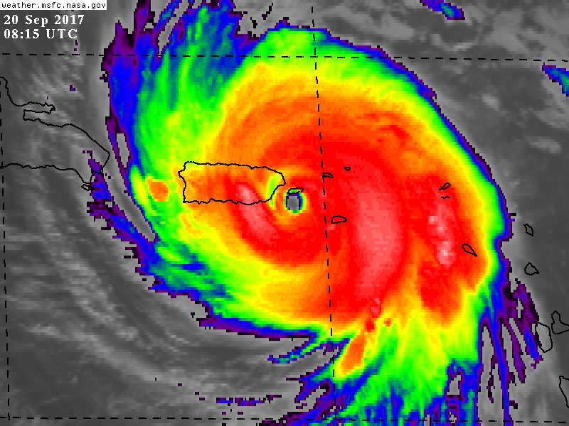
...MARIA MAKES LANDFALL NEAR YABUCOA PUERTO RICO...

Geostationary satellite images and surface observations indicate
that the center of Hurricane Maria made landfall near Yabucoa,
Puerto Rico, around 615 AM AST.


A sustained wind 60 mph (96 km/h) with a wind gust to 113 mph (182
km/h) was recently reported at Yabucoa Harbor, Puerto Rico.

A National Ocean Service tide gauge at Yabucoa Harbor, Puerto Rico,
recently reported a water level of 4.3 ft above Mean Higher High
Water (MHHW).

SUMMARY OF 635 AM AST...1035 UTC...INFORMATION
---------------------------------------------------
LOCATION...18.0N 65.8W
ABOUT 20 MI...35 KM WSW OF VIEQUES
ABOUT 35 MI...55 KM SE OF SAN JUAN PUERTO RICO
MAXIMUM SUSTAINED WINDS...155 MPH...250 KM/H
PRESENT MOVEMENT...NW OR 305 DEGREES AT 10 MPH...17 KM/H
MINIMUM CENTRAL PRESSURE...917 MB...27.08 INCHES

$$

Forecaster Berg

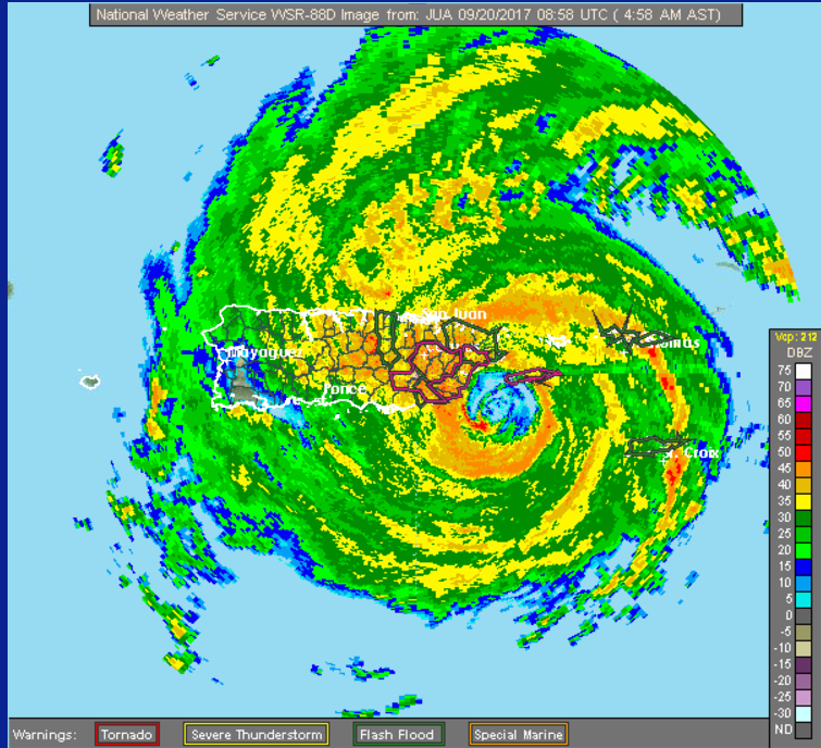
NWS radar image from Puerto Rico_Virgin Islands.png

rb-animated.gif

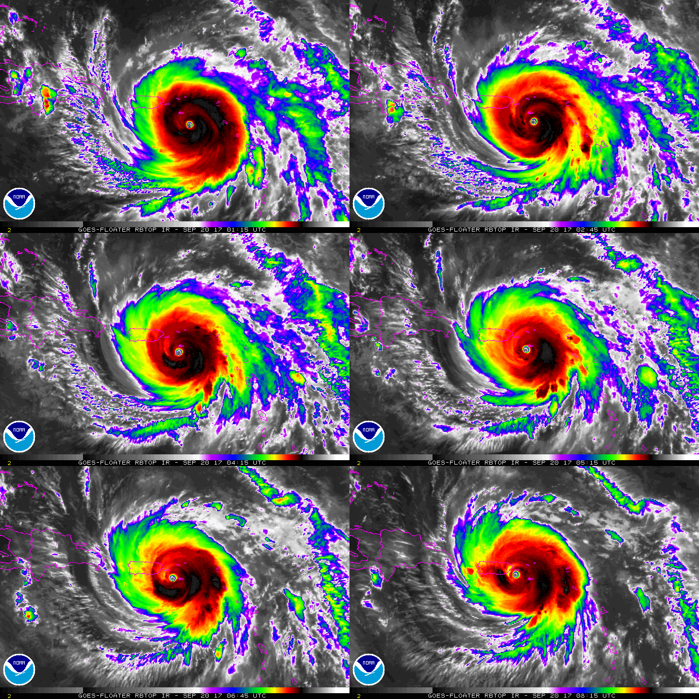
GOES10302017263kX5Qjs.jpg

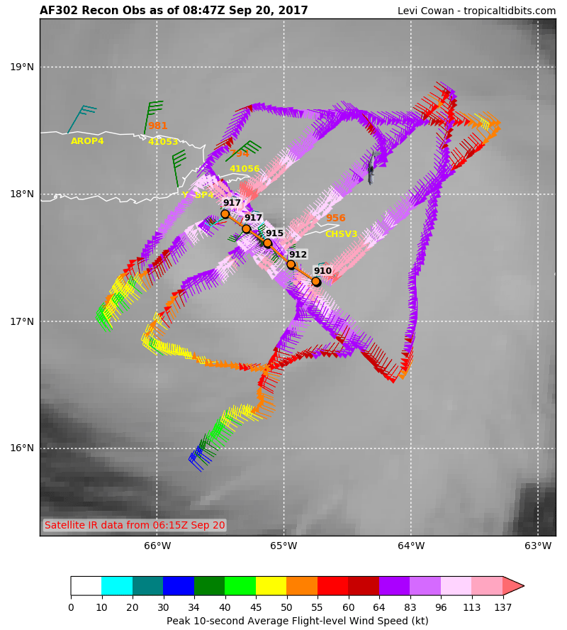
recon_AF305-0815A-MARIA.png

WUNIDS_map.gif
回復

使用道具 舉報

簽到天數: 241 天

[LV.8]以壇為家I

krichard2011|2017-9-20 17:46 | 顯示全部樓層
瑪莉亞颶爆發增強時的密集閃電~
擷取華盛頓大學的閃電即時定位系統 (WWLLN)
2017.09.19 15:10 UTC ~ 2017.09.19 16:10 UTC
與 2017.09.19 23:10 UTC ~ 2017.09.20 00:10 UTC
可以發現
前者在爆發增強階段有相當明顯密集閃電發生 且相當規則地分布在眼牆周圍
當颶風強度到達極盛期時(後者) 眼牆閃電頻率則明顯降低
很特別的現象 紀錄一下

*顏色說明
紅色表示 10分鐘以內之閃電
橙色表示 10~30分鐘之內發生的閃電
黃色表示 30~60分鐘之內發生之閃電
20170919.1615.goes13.x.ir1km_bw.15LMARIA.140kts-931mb-161N-627W.100pc.png
20170920.0015.goes13.x.ir1km_bw.15LMARIA.145kts-920mb-166N-636W.100pc.png

點評

2013年的海燕和2016年的莫蘭蒂也有這樣密集的閃電出現在眼牆周遭,不過就算到頂了也還未見到極限,反而閃電出現得更凶狠了。不知道是否與熱塔(Heat Tower)出現有相當的關係?  詳情 回復 發表於 2017-9-20 20:10
回復

使用道具 舉報

簽到天數: 3279 天

[LV.Master]伴壇終老

t02436|2017-9-20 17:04 | 顯示全部樓層
眼牆置換完成,不過09Z降到135節,馬上要登陸波多黎各了...
ZCZC MIATCDAT5 ALL
TTAA00 KNHC DDHHMM

Hurricane Maria Discussion Number  17
NWS National Hurricane Center Miami FL       AL152017
500 AM AST Wed Sep 20 2017

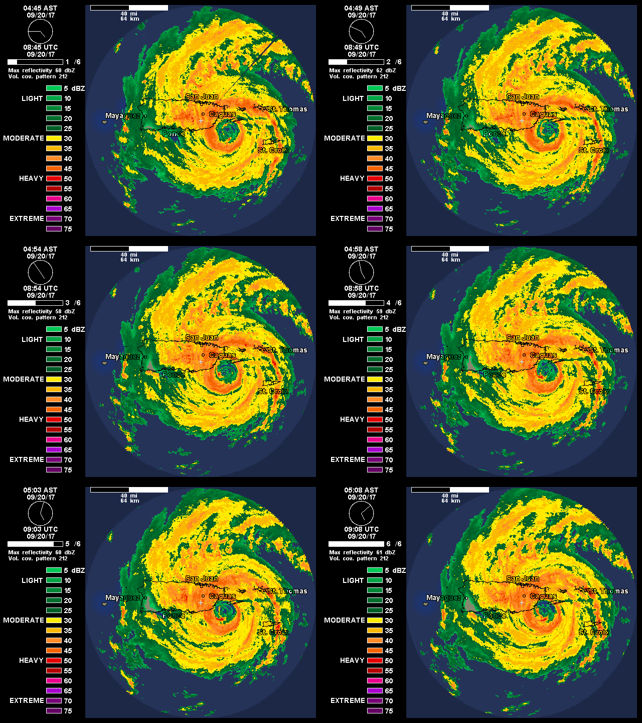
Radar observations from the San Juan WSR-88D and wind data from an
Air Force Reserve Unit Hurricane Hunter aircraft indicate that
Maria has just about completed an eyewall replacement.  Based on
the now-dominant outer eyewall, the eye diameter has increased from
10 n mi to 30 n mi.  This has likely contributed to some weakening,
and based on the latest observations from the Hurricane Hunters, the
intensity is set at 135 kt which is at the top of category 4 range.
Although there has been a slight reduction of intensity, Maria
remains an extremely dangerous hurricane.  Some weakening is
likely while the system crosses Puerto Rico.  Later in the forecast
period, less favorable upper-level winds should cause further
weakening, but Maria is likely to remain a large and powerful
hurricane for the next 5 days.  The official intensity forecast is
near or a little above the model consensus.

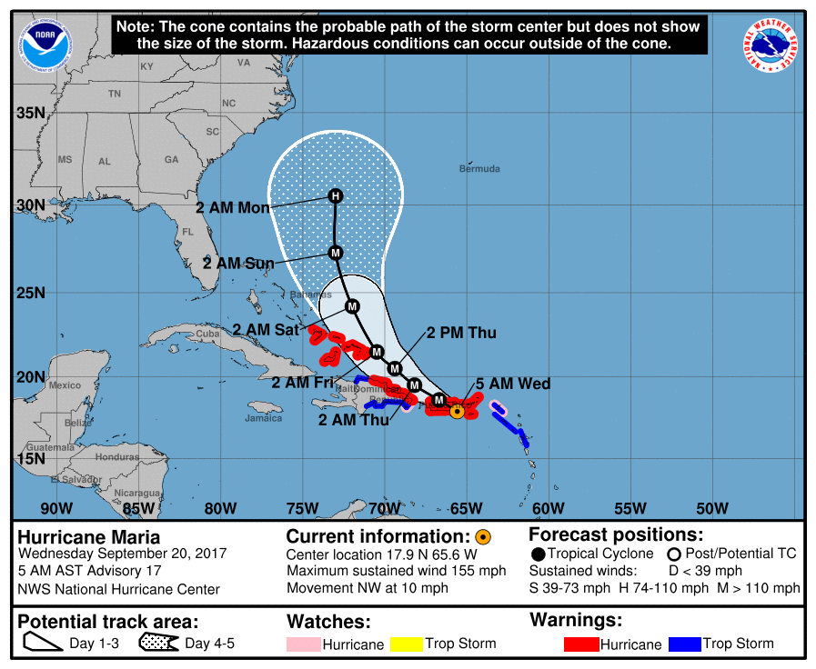
Maria continues to move between west-northwest and northwest at
about 9 kt.  The flow on the south side of a weak mid-level ridge
over the western Atlantic is expected to steer the hurricane on this
general heading over the next couple of days.  This track will bring
the center of Maria across Puerto Rico and just north of the eastern
Dominican Republic over the next day or so.  After that time a
break in the ridge, partially associated with Tropical Storm Jose,
should cause Maria to turn north-northwestward, then northward by
the end of the forecast period.  The track guidance remains tightly
clustered through 72 hours, giving fairly high confidence in the
track forecast through that time.  There is some increase in the
spread of the models at days 4 and 5, with the latest ECMWF
prediction near the western edge of the guidance envelope but with
all of the reliable models well offshore of the southeast U.S. at
the end of the period.  The official forecast is very close to the
latest FSU Superensemble track.

KEY MESSAGES:

1. Maria's core will make landfall over Puerto Rico within the
next couple of hours, bringing life-threatening wind, storm surge,
and rainfall impacts to the island.  Everyone in Puerto Rico should
follow advice from local officials to avoid life-threatening
flooding from storm surge and rainfall.

2. Wind speeds atop and on the windward sides of hills and mountains
and on high-rise buildings could be much stronger than the
near-surface winds indicated in this advisory.

3. A Hurricane Warning is also in effect for the Virgin Islands,
the northern coast of the Dominican Republic, the Turks and
Caicos Islands and the southeastern Bahamas, where Maria is expected
to bring dangerous wind, storm surge, and heavy rainfall.

FORECAST POSITIONS AND MAX WINDS

INIT  20/0900Z 17.9N  65.6W  135 KT 155 MPH
12H  20/1800Z 18.6N  66.7W  125 KT 145 MPH...INLAND
24H  21/0600Z 19.5N  68.2W  120 KT 140 MPH
36H  21/1800Z 20.5N  69.4W  120 KT 140 MPH
48H  22/0600Z 21.5N  70.5W  115 KT 130 MPH
72H  23/0600Z 24.2N  72.0W  105 KT 120 MPH
96H  24/0600Z 27.3N  73.0W  100 KT 115 MPH
120H  25/0600Z 30.5N  73.0W   85 KT 100 MPH

$$
Forecaster Pasch

NNNN
090927_5day_cone_with_line.png

NWS radar image from Puerto Rico_Virgin Islands.png

GOES08152017263kWekFg.jpg

recon_AF302-0715A-MARIA.png

rbtop-animated.gif

WUNIDS_map.gif

點評

上次海燕的風潮暴沒看準..這個比海燕小兩個級數的[馬里亞]看能在中心附近有什麼驚天的暴力紀錄!  發表於 2017-9-20 17:11
回復

使用道具 舉報

簽到天數: 3198 天

[LV.Master]伴壇終老

king111807|2017-9-20 14:31 | 顯示全部樓層
21558550_2050628121617851_3349828855096199403_n.jpg

【Maria颶風重返五級,稍後登陸波多黎各】
才剛徹底摧毀多米尼克的颶風Maria,已經重新增強回五級颶風。
目前Maria強度150kts,暫居今年全球第二強的熱帶氣旋。
 
綜觀目前及未來環境,現在的Maria應當已屆巔峰,其實最新的雷達圖已經有雙眼牆出現的狀況,之後估計會稍微減弱一點點,接著在台灣時間今天傍晚會登陸波多黎各,這將是當地幾十年來威脅最大的颶風之一,尤其前陣子Irma颶風的災後復原才剛開始,現在又遇到Maria,實在是令人擔心。

點評

和艾瑪一樣完整的底層  發表於 2017-9-20 15:33
85年來最強  發表於 2017-9-20 15:14
回復

使用道具 舉報

簽到天數: 3279 天

[LV.Master]伴壇終老

t02436|2017-9-20 12:40 | 顯示全部樓層
氣壓再降至908mb,北側眼牆正在通過美屬維京群島。
ZCZC MIATCUAT5 ALL
TTAA00 KNHC DDHHMM

Hurricane Maria Tropical Cyclone Update
NWS National Hurricane Center Miami FL       AL152017
1200 AM AST Wed Sep 20 2017

...1200 AM AST POSITION AND INTENSITY UPDATE...
...SUSTAINED HURRICANE-FORCE WINDS REPORTED ON ST. CROIX...

A sustained wind of 75 mph (120 km/h) with a wind gust to 114 mph
(183 km/h) was recently reported in the western portion of St. Croix
in the U.S. Virgin Islands.


SUMMARY OF 1200 AM AST...0400 UTC...INFORMATION
---------------------------------------------------
LOCATION...17.4N 64.9W
ABOUT 20 MI...35 KM SSW OF ST. CROIX
ABOUT 105 MI...170 KM SE OF SAN JUAN PUERTO RICO
MAXIMUM SUSTAINED WINDS...175 MPH...280 KM/H
PRESENT MOVEMENT...WNW OR 300 DEGREES AT 10 MPH...17 KM/H
MINIMUM CENTRAL PRESSURE...908 MB...26.81 INCHES

$$

Forecaster Blake

NNNN

GOES04152017263rpyNnL.jpg

20170920.0151.gpm.89pct89h89v.15L.MARIA.150kts.909mb.17N.64.3W.055pc.jpg

recon_AF302-0715A-MARIA.png

rbtop-animated.gif

回復

使用道具 舉報

簽到天數: 588 天

[LV.9]以壇為家II

Meow|2017-9-20 11:28 | 顯示全部樓層
9月19日背風群島颶風瑪莉亞接近巔峰並進逼波多黎各
Maria 2017-09-19 1742Z (gallery).jpg
https://commons.wikimedia.org/wi ... 1742Z_(gallery).jpg
回復

使用道具 舉報

簽到天數: 601 天

[LV.9]以壇為家II

霧峰追風者|2017-9-20 09:44 | 顯示全部樓層
NHC 強度提升 150KT ,逐漸接近波多黎各。
235857_5day_cone_no_line_and_wind.png 20170920.0045.goes-13.ircolor.15L.MARIA.150kts.909mb.17N.64.3W.100pc.jpg rb-animated.gif

點評

颶風中心穿過波多黎東北端,非橫貫波多黎各,比之前預期好些。  發表於 2017-9-20 10:16
回復

使用道具 舉報

快速回覆
您需要登錄後才可以回帖 登錄 | 立即加入

本版積分規則

本平台僅供學術討論之用,預報應以氣象局為準

威普網站虛擬主機贊助公司

臺灣第一個天氣類型社群平台 即時天氣資訊、精準颱風動態

線上客服
FB傳送訊息
廣告行銷
精準行銷 物超所值
官方粉專
發佈 快速回復 返回頂部 返回列表