開啟輔助訪問
 找回密碼
 立即加入

02E.Blanca

簽到天數: 1650 天

[LV.Master]伴壇終老

2021-5-30 02:46 | 顯示全部樓層
  熱帶風暴  
編號:02 E
名稱:Blanca
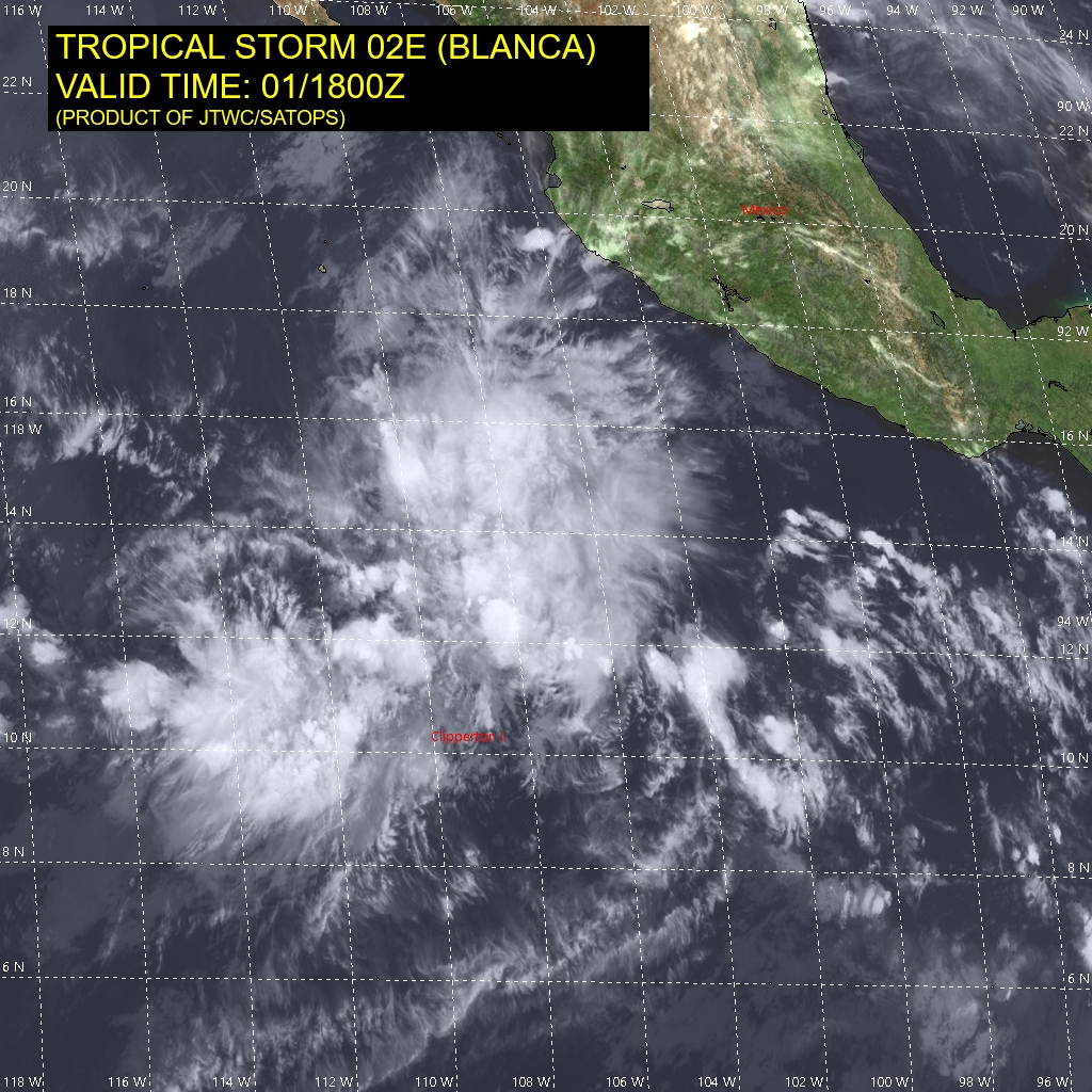
20210601.0610.goes-17.ir.02E.BLANCA.45kts.1001mb.13.7N.109.1W.100pc.jpg
  基本資料  
擾動編號日期:2021 05 30 02
命名日期  :2021 06 01 05
撤編日期  :2021 06 06 23
登陸地點  :


  巔峰時期資料  
近中心最強風速 :50  kt (
TS )
海平面最低氣壓 :998 百帕

  擾動編號資料  

91E.INVEST.20kts.1009mb.9.6N.99.9W
20210529.1820.goes-17.vis.2km.91E.INVEST.20kts.1009mb.9.6N.99.9W.pc.jpg


  NHC:40%  
2. A broad area of low pressure located several hundred miles south of
Acapulco, Mexico, continues to produce disorganized shower and
thunderstorm activity.  However, environmental conditions are
expected to be conducive for development of this system during the
next several days, and a tropical depression is likely to form by
the middle of next week while the system moves westward to
west-northwestward at about 10 mph.
* Formation chance through 48 hours...medium...40 percent.
* Formation chance through 5 days...high...70 percent.

two_pac_2d2 (2).png two_pac_5d2 (3).png
以上資料來自:NHC、颱風論壇整理製作

評分

參與人數 1水氣能量 +15 +1 收起 理由
周子堯@FB + 15 + 1 熱帶擾動首帖

查看全部評分

回復

使用道具 舉報

簽到天數: 1650 天

[LV.Master]伴壇終老

老農民版夜神月|2021-6-6 23:30 | 顯示全部樓層
FNMOC15Z撤編
20210606.1440.goes-17.vis.2km.02E.BLANCA.20kts.1008mb.16.5N.118.9W.pc.jpg 20210606.0957.gw1.89pct89h89v.02E.BLANCA.20kts.1008mb.16.5N.118.9W.68pc.jpg
20210606.0957.gw1.89hbt.02E.BLANCA.20kts.1008mb.16.5N.118.9W.68pc.jpg
回復

使用道具 舉報

簽到天數: 483 天

[LV.9]以壇為家II

dom|2021-6-4 17:55 | 顯示全部樓層
NHC判定成為後熱帶氣旋
000
WTPZ42 KNHC 040833
TCDEP2

Post-Tropical Cyclone Blanca Discussion Number  19
NWS National Hurricane Center Miami FL       EP022021
200 AM PDT Fri Jun 04 2021

Blanca has been devoid of organized deep convection since midday
yesterday, with the last convective burst near the center ceasing
over 15 hours ago. Since that time there have been a few convective
cells noted 120 to 150 n mi east-northeast of the center, but these
have been short lived. This is a big change from this time
yesterday, when a large burst of deep convection developed during
the diurnal maximum close the center of the cyclone. This trend is
indicative of the strong west-southwesterly shear and the dry and
stable atmospheric environment taking their toll on the system.
These hostile environmental factors are not expected to improve,
while the forward path of the cyclone takes it over progressively
cooler waters.  Therefore, it is anticipated that persistent deep
convection will not redevelop near the center of the system, and
Blanca is being designated as a remnant low. The low is expected to
gradually spin down and is likely to dissipate within the next few
days. The overnight ASCAT overpasses did not sample the center of
the system, so a blend of the T/CI numbers of 1.0/2.0 from the most
recent satellite intensity estimate from TAFB supports maintaining
the advisory intensity at 25 kt.

Over the past 12 hours Blanca has been moving west-northwestward, or
300/06 kt. A turn to the west is expected later this morning as the
shallow system gets caught up in the flow around a low-level ridge
to the north. This westward motion should continue until the system
dissipates. The latest NHC track forecast is little changed from the
previous one and is near the multi-model consensus.

This is the last NHC advisory on Blanca. For additional information
on the remnant low please see High Seas Forecasts issued by the
National Weather Service, under AWIPS header NFDHSFEPI, WMO header
FZPN02 KWBC, and on the web at ocean.weather.gov/shtml/NFDHSFEPI.php


FORECAST POSITIONS AND MAX WINDS

INIT  04/0900Z 16.3N 115.6W   25 KT  30 MPH...POST-TROPICAL
12H  04/1800Z 16.4N 116.8W   25 KT  30 MPH...POST-TROP/REMNT LOW
24H  05/0600Z 16.4N 118.3W   25 KT  30 MPH...POST-TROP/REMNT LOW
36H  05/1800Z 16.4N 119.7W   20 KT  25 MPH...POST-TROP/REMNT LOW
48H  06/0600Z 16.4N 121.1W   20 KT  25 MPH...POST-TROP/REMNT LOW
60H  06/1800Z 16.4N 122.5W   20 KT  25 MPH...POST-TROP/REMNT LOW
72H  07/0600Z...DISSIPATED

$$
Forecaster Latto
083424_5day_cone_no_line_and_wind.png
回復

使用道具 舉報

簽到天數: 1650 天

[LV.Master]伴壇終老

老農民版夜神月|2021-6-4 06:47 | 顯示全部樓層
NHC預測+24H後便將成為後熱帶氣旋
000
WTPZ42 KNHC 032041
TCDEP2

Tropical Depression Blanca Discussion Number  17
NWS National Hurricane Center Miami FL       EP022021
300 PM MDT Thu Jun 03 2021

Like the past two days, deep convection that had been present near
Blanca this morning has sheared away and collapsed this afternoon,
revealing an increasingly diffuse structure with multiple low-level
swirls. Subjective Dvorak estimates at 1800Z were 30 kt from TAFB
and too weak to classify by SAB. The most recent UW-CIMSS ADT
objective estimate was a little higher at 35 kt. Unfortunately,
Blanca was missed by all three scatterometer overpasses this
afternoon. However, assuming little change in the wind field has
occurred from last night, the current intensity has been held at 30
kt for this advisory.

Blanca's mean circulation center has resumed a slow due west motion
at 270/3 kt, though some uncertainty exists since multiple low-level
swirls are evident on visible satellite imagery. Now that convection
has weakened once again, the steering currents will be dominated by
the flow around a poleward low-level ridge. This flow is expected to
keep Blanca on a westward heading for the remainder of its lifespan.
The latest track forecast is largely an update from the previous
forecast cycle and is in close agreement between the TCVE and HCCA
consensus aids.

Now that convection near the center of Blanca has largely
dissipated, the clock has been reset for its remaining lifespan as a
tropical cyclone. While the current NHC forecast does not preclude
the possibility that another convective burst could occur over the
next 24 h, increasingly dry, stable air from the northwest and
continued unfavorable southwesterly vertical wind shear should limit
any significant convective organization near Blanca's center. The
latest NHC intensity forecast expects Blanca to become a remnant low
on Friday, with the remnant low likely opening up into a trough by
the end of the weekend.


FORECAST POSITIONS AND MAX WINDS

INIT  03/2100Z 15.5N 114.3W   30 KT  35 MPH
12H  04/0600Z 15.5N 115.5W   25 KT  30 MPH
24H  04/1800Z 15.6N 117.1W   25 KT  30 MPH...POST-TROP/REMNT LOW
36H  05/0600Z 15.7N 118.7W   25 KT  30 MPH...POST-TROP/REMNT LOW
48H  05/1800Z 15.8N 120.3W   25 KT  30 MPH...POST-TROP/REMNT LOW
60H  06/0600Z 15.9N 121.4W   20 KT  25 MPH...POST-TROP/REMNT LOW
72H  06/1800Z...DISSIPATED

$$
Forecaster Papin/Stewart
204216_5day_cone_no_line_and_wind.png ep0221 (6).gif
02E_gefs_latest (1).png 02E_031800sair.jpg
回復

使用道具 舉報

簽到天數: 1650 天

[LV.Master]伴壇終老

老農民版夜神月|2021-6-3 05:07 | 顯示全部樓層
本帖最後由 老農民版夜神月 於 2021-6-3 06:01 編輯

NHC21Z報判定降格TD
000
WTPZ42 KNHC 022111
TCDEP2

Tropical Depression Blanca Discussion Number  13...Retransmitted
NWS National Hurricane Center Miami FL       EP022021
300 PM MDT Wed Jun 02 2021

The satellite structure of Blanca has continued to deteriorate this
afternoon. Visible satellite imagery shows an exposed low-level
swirl, and that circulation is becoming increasingly elongated. The
nearest deep convection is now more than 100 nm southeast of the
circulation center. A fortuitous 1519 UTC ASCAT-A pass over Blanca
revealed that the tropical cyclone may have been weaker than earlier
assessed with a peak wind retrieval of only 28 kt in the
northeastern quadrant. Even after accounting for instrument
undersampling, the lack of significant convection near the wind
field since that time has likely resulted in further spin down of
the vortex. The latest subjective Dvorak estimates were also down to
30 kt from SAB and 35 kt from TAFB. Given the deterioration of the
structure since then, Blanca is being downgraded to a 30-kt
tropical depression at this time.

As Blanca's low-level circulation has become increasingly detached
from the deep convection, the motion of the storm has turned more
westward at 280/4 kt. Now that Blanca appears to be a shallow
low-level feature, it will be primarily steered by the low-level
easterly trade wind flow. This will force Blanca westward over the
next several days as the circulation slowly spins down. The latest
NHC track forecast is largely an update from the previous one and
remains closest to the HCCA consensus model which is on the left
side of the guidance envelope.

Aside from the limited deep convection well separated from Blanca's
center, the storm already barely meets the criteria of a tropical
cyclone. It appears that dry, stable air that entered the
circulation from the northwest, aided by unfavorable vertical wind
shear, is winning the battle over sufficiently warm sea-surface
temperatures beneath the circulation. With the wind field spinning
down compared to 24 h ago, nocturnal re-formation of deep central
convection will find it more challenging to overcome the dry stable
airmass that the storm is embedded in. In addition, both the 12z
GFS- and ECMWF-model-forecast simulated IR brightness temperature
have trended towards less convective activity the last few cycles.
The current NHC forecast assumes occasional diurnal convective
bursts will help to maintain the status of the tropical cyclone for
another 24-36 h, but it is possible that Blanca could become a
remnant low as soon as tomorrow afternoon if convection does not
redevelop by then.


FORECAST POSITIONS AND MAX WINDS

INIT  02/2100Z 15.5N 112.8W   30 KT  35 MPH
12H  03/0600Z 15.5N 113.4W   30 KT  35 MPH
24H  03/1800Z 15.4N 114.2W   30 KT  35 MPH
36H  04/0600Z 15.3N 115.5W   25 KT  30 MPH
48H  04/1800Z 15.2N 117.0W   25 KT  30 MPH...POST-TROP/REMNT LOW
60H  05/0600Z 15.2N 118.5W   20 KT  25 MPH...POST-TROP/REMNT LOW
72H  05/1800Z 15.2N 119.8W   20 KT  25 MPH...POST-TROP/REMNT LOW
96H  06/1800Z...DISSIPATED

$$
Forecaster Papin/Stewart

203910_5day_cone_no_line_and_wind.png ep0221 (5).gif 02E_gefs_latest.png 02E_021800sair.jpg
回復

使用道具 舉報

簽到天數: 1650 天

[LV.Master]伴壇終老

老農民版夜神月|2021-6-2 05:06 | 顯示全部樓層
NHC認定已開始減弱,預測+96H後將成為殘餘低氣壓
000
WTPZ42 KNHC 012039
TCDEP2

Tropical Storm Blanca Discussion Number   9
NWS National Hurricane Center Miami FL       EP022021
300 PM MDT Tue Jun 01 2021

Over the last 12 h, Blanca's convective structure has continued to
degrade. The low-level circulation center is now fully exposed to
the west of a small region of deep convection, though
disorganized convective towers are currently trying to redevelop
closer to the center. Even though deep-layer southwesterly
200-850-mb vertical wind shear diagnosed by GFS-SHIPS is still only
15-20 kt, stronger 25-30 kt mid-level shear appears to be
undercutting Blanca's outflow layer. This shear may have resulted in
Blanca ingesting dry, stable mid-level air from the west that has
significantly disrupted the cyclone's convective structure today.
Unfortunately all three scatterometer passes missed Blanca's center
and maximum winds this afternoon. However, given the marked decrease
in organization of Blanca's structure, plus recent subjective
satellite estimates from SAB and TAFB at T3.0/45 kt, the initial
intensity has been lowered to 45 kt for this advisory.

Blanca's exposed center has made it easier to determine its current
position and motion, which over the past 12 h is estimated at 300/8
kt, though the shorter-term motion has been more westward. As
previously discussed, the mid-level ridge that had been steering
Blanca to the west-northwest has been gradually weakening as a
pronounced mid- to upper-level trough centered over the Baja
California peninsula digs in. The end result is Blanca's forward
motion toward the west-northwest is likely to slow further.
Additional asymmetric convective bursts primarily occuring east of
the low-level center may also act to slow down Blanca's forward
motion. As the storm becomes more vertically shallow, it will
increasingly be influenced by the low-level steering flow resulting
in a gradual westward bend in the forecast track until Blanca
dissipates. The latest NHC forecast track has shifted a bit more
south and west this cycle, owing to the possibility that Blanca may
become a shallow vortex sooner than expected, but still agrees
closely with the HCCA corrected consensus with a little more weight
placed on the leftward bending guidance.

The same mid- to upper-level trough slowing the steering currents
have also resulted in a significant increase in mid-level shear over
Blanca, halting any further intensification. Over the next 12-24 h,
intermittent diurnal convective bursts as the cyclone remains over
28-29 C sea surface temperatures should lead to only gradual
weakening. However, even drier mid-level air and lower sea-surface
temperatures exist along Blanca's forecast track and the cyclone is
forecast to weaken to a tropical depression by 60 h and degenerate
to a remnant low by 96 h, though this could occur sooner if
organized convection dissipates faster than forecast.


FORECAST POSITIONS AND MAX WINDS

INIT  01/2100Z 14.7N 110.9W   45 KT  50 MPH
12H  02/0600Z 15.0N 111.6W   40 KT  45 MPH
24H  02/1800Z 15.4N 112.3W   40 KT  45 MPH
36H  03/0600Z 15.6N 112.9W   35 KT  40 MPH
48H  03/1800Z 15.7N 113.5W   35 KT  40 MPH
60H  04/0600Z 15.7N 114.4W   30 KT  35 MPH
72H  04/1800Z 15.8N 115.5W   30 KT  35 MPH
96H  05/1800Z 15.9N 117.6W   25 KT  30 MPH...POST-TROP/REMNT LOW
120H  06/1800Z 15.9N 119.2W   25 KT  30 MPH...POST-TROP/REMNT LOW

$$
Forecaster Papin/Stewart
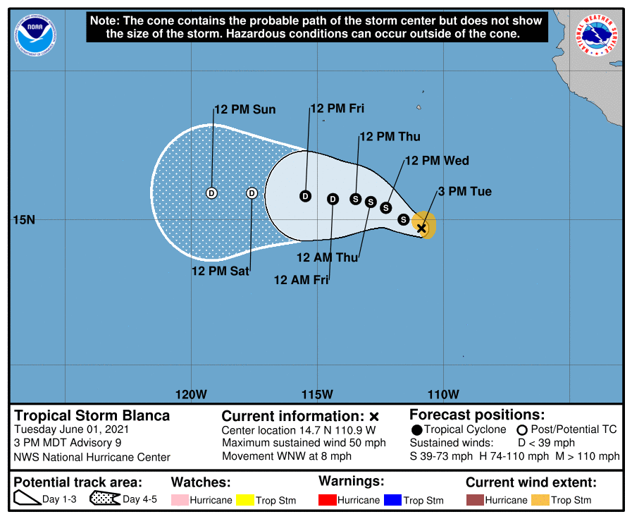
204019_5day_cone_no_line_and_wind.png ep0221 (4).gif
02E_011800sair.jpg
回復

使用道具 舉報

簽到天數: 1650 天

[LV.Master]伴壇終老

老農民版夜神月|2021-6-2 02:30 | 顯示全部樓層
NHC15Z維持50節,並預測即將開始減弱
000
WTPZ42 KNHC 011458
TCDEP2

Tropical Storm Blanca Discussion Number   8
NWS National Hurricane Center Miami FL       EP022021
900 AM MDT Tue Jun 01 2021

Blanca's satellite appearance has degraded some this morning, with
the convective structure evolving more into a shear pattern. Recent
SSMIS microwave passes and first-light visible imagery suggest the
center is now located on the southwest edge of a recent convective
burst. The latest subjective Dvorak classifications are lower than
last night with T2.5/35 kt from SAB and T3.0/45 kt from TAFB. The
initial intensity was kept at 50 kt for this advisory, but that
could be generous.

The cyclone's estimated motion is 300/6 kt, a bit more westward than
before. The track philosophy has not changed much this advisory, as
a mid- to upper-level trough near the Baja California peninsula is
beginning to weaken the steering ridge. Thus, Blanca is expected to
move generally west-northwestward with a continued decrease in
forward speed over the next couple of days. Afterwards, the system
should turn more westward within the low-level trade winds as it
becomes vertically shallow. The latest NHC forecast track is a bit
further southward than the previous advisory, but remains close to
the HCCA corrected consensus aid.

First-light visible imagery suggests that the low-level center of
Blanca may be in the process of becoming exposed. Owing to the
degradation in the current satellite structure, Blanca is no longer
expected to intensify, and in fact may already be weaker than
currently estimated. Increasing vertical wind shear appears to be
disrupting the current structure of the cyclone. A gradual weakening
trend is now forecast to begin by this evening through the end of
the forecast period as Blanca moves into an environment of drier
mid-level air and cooler sea surface temperatures. The NHC intensity
forecast remains close to the HCCA and ICON consensus aids.


FORECAST POSITIONS AND MAX WINDS

INIT  01/1500Z 14.3N 110.2W   50 KT  60 MPH
12H  02/0000Z 14.8N 110.8W   45 KT  50 MPH
24H  02/1200Z 15.2N 111.7W   45 KT  50 MPH
36H  03/0000Z 15.5N 112.3W   40 KT  45 MPH
48H  03/1200Z 15.6N 112.9W   35 KT  40 MPH
60H  04/0000Z 15.7N 113.7W   30 KT  35 MPH
72H  04/1200Z 15.8N 114.6W   30 KT  35 MPH
96H  05/1200Z 16.1N 116.7W   25 KT  30 MPH
120H  06/1200Z 16.5N 118.4W   25 KT  30 MPH...POST-TROP/REMNT LOW

$$
Forecaster Papin/Stewart
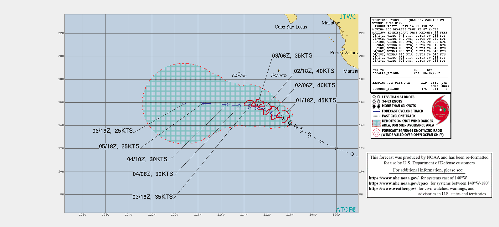
145619_5day_cone_no_line_and_wind.png ep0221 (3).gif
02E_011200sair.jpg
回復

使用道具 舉報

簽到天數: 483 天

[LV.9]以壇為家II

dom|2021-6-1 11:01 | 顯示全部樓層
本帖最後由 dom 於 2021-6-1 14:12 編輯

NHC00Z定強提升至50節,預測於半天內達到巔峰
791
WTPZ42 KNHC 010240
TCDEP2

Tropical Storm Blanca Discussion Number   6
NWS National Hurricane Center Miami FL       EP022021
900 PM MDT Mon May 31 2021

The satellite presentation of Blanca has continued to improve this
evening. Bursts of deep convection have recently developed near the
estimated center, which has led to an increase in banding that can
be seen in the latest microwave imagery. Subjective Dvorak
classifications are T3.0 (45 kt) and T3.5 (55 kt) from TAFB and
SAB, respectively.  Based on these data and the continued
organization seen in recent satellite imagery, the initial
intensity has been set at 50 kt for this advisory.

Blanca is currently located within a favorable environment for
strengthening that consists of low vertical wind shear, warm sea
surface temperatures, and a moist atmosphere.  These conditions
favor additional strengthening during the next 12 hours or so, but
by Tuesday afternoon increasing southwesterly shear is likely to
put an end to Blanca's intensification phase.  After that time, an
additional increase in shear and gradually decreasing sea surface
temperatures are expected to cause slow weakening throughout the
remainder of the forecast period.  Blanca is now forecast to become
a remnant low by day 5, but it could occur a little sooner than
that.  The NHC intensity forecast is in best agreement with the
HCCA and ICON consensus aids.

The initial motion estimate is 300/8 kt, a little slower toward the
west-northwest than before.  A deepening mid- to upper-level trough
near the central portion of the Baja peninsula is forecast to
weaken the western extent of the ridge, which is expected to cause
Blanca to slow its forward speed over the next couple of days.  As
the tropical storm weakens in 2-3 days, it should turn more westward
when it becomes a vertically shallow system and is steered by the
low-level easterly trade wind flow.  Although there is an increase
in the spread of the guidance after 72 hours, the latest NHC track
forecast remains near the middle of the guidance envelope, and it
is very similar to the previous official forecast.


FORECAST POSITIONS AND MAX WINDS

INIT  01/0300Z 13.9N 109.4W   50 KT  60 MPH
12H  01/1200Z 14.4N 110.4W   55 KT  65 MPH
24H  02/0000Z 15.1N 111.6W   50 KT  60 MPH
36H  02/1200Z 15.6N 112.5W   45 KT  50 MPH
48H  03/0000Z 15.9N 113.2W   40 KT  45 MPH
60H  03/1200Z 16.0N 113.8W   35 KT  40 MPH
72H  04/0000Z 16.1N 114.6W   35 KT  40 MPH
96H  05/0000Z 16.1N 116.5W   30 KT  35 MPH
120H  06/0000Z 16.2N 118.4W   25 KT  30 MPH...POST-TROP/REMNT LOW

$$
Forecaster Brown
024124_5day_cone_no_line_and_wind.png
回復

使用道具 舉報

12下一頁
快速回覆
您需要登錄後才可以回帖 登錄 | 立即加入

本版積分規則

本平台僅供學術討論之用,預報應以氣象局為準

威普網站虛擬主機贊助公司

臺灣第一個天氣類型社群平台 即時天氣資訊、精準颱風動態

線上客服
FB傳送訊息
廣告行銷
精準行銷 物超所值
官方粉專
發佈 快速回復 返回頂部 返回列表