簽到天數: 1650 天 [LV.Master]伴壇終老
|
 老農民版夜神月|2019-7-31 11:34
|
顯示全部樓層
本帖最後由 老農民版夜神月 於 2019-7-31 11:39 編輯
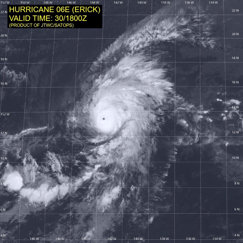
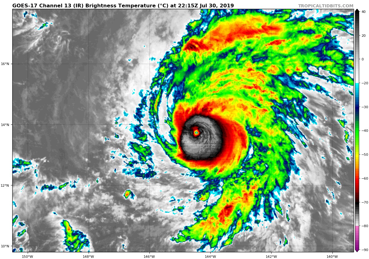
CPHC30/18Z及31/03Z兩報,均定強115KT.06E.Erick成為今年第二個強度達C4的颶風
30/18Z
WTPA41 PHFO 302102
TCDCP1
Hurricane Erick Discussion Number 14
NWS Central Pacific Hurricane Center Honolulu HI EP062019
1100 AM HST Tue Jul 30 2019
Convection consolidated over the center of Erick as the sun set on
Monday, and the hurricane has rapidly intensified since then.
Satellite imagery shows a persistent warm eye surrounded by a solid
ring of deep convection that is producing bursts of eyewall
lightning, indicating that the intensification trend continues.
Subjective Dvorak intensity estimates are 6.0/115 kt, leading to an
initial intensity estimate of 115 kt, making Erick a category 4
hurricane.
The window for further intensification appears to be small, as
increased vertical wind shear (30-40 kt) lies along the forecast
track, especially after about 36 hours. Once Erick encounters this
southwesterly shear, associated with a semi-permanent upper-level
trough northwest of Hawaii, a rapid weakening trend is expected. In
the meantime, slight intensification is anticipated, although an
eyewall replacement cycle cannot be completely ruled out. Latest
intensity guidance supports the ongoing forecast, and little
significant change was made to the official forecast, which closely
follows trends presented by the intensity consensus IVCN.
The forward motion of the cyclone has slowed since yesterday, and
the initial motion estimate for this advisory is 275/13 kt. In the
mid-levels, Erick is being steered by a ridge to the north that is
expected to build westward over the next couple of days. A slight
turn to the west-northwest and some slowing in forward speed is
expected in the short term as Erick remains a strong hurricane
interacting with the deep-layer flow. There are still notable
differences amongst the track models through this time frame, with
HWRF/COAMPS-TC to the right of the official forecast, and ECMWF to
the left. With most guidance tending to be too slow and poleward to
this point, the official forecast was nudged equatorward, closer to
the well-performing ECMWF guidance, and close to FSSE/HCCA. Toward
the end of the forecast period, Erick will reach the western
periphery of the ridge, allowing the weakened cyclone to gain
latitude.
FORECAST POSITIONS AND MAX WINDS
INIT 30/2100Z 13.6N 144.1W 115 KT 130 MPH
12H 31/0600Z 14.2N 145.8W 125 KT 145 MPH
24H 31/1800Z 14.9N 147.9W 115 KT 130 MPH
36H 01/0600Z 15.3N 150.2W 100 KT 115 MPH
48H 01/1800Z 15.8N 152.5W 85 KT 100 MPH
72H 02/1800Z 16.8N 157.5W 50 KT 60 MPH
96H 03/1800Z 18.5N 162.0W 40 KT 45 MPH
120H 04/1800Z 20.0N 165.0W 35 KT 40 MPH
$$
Forecaster Birchard
31/03Z
000
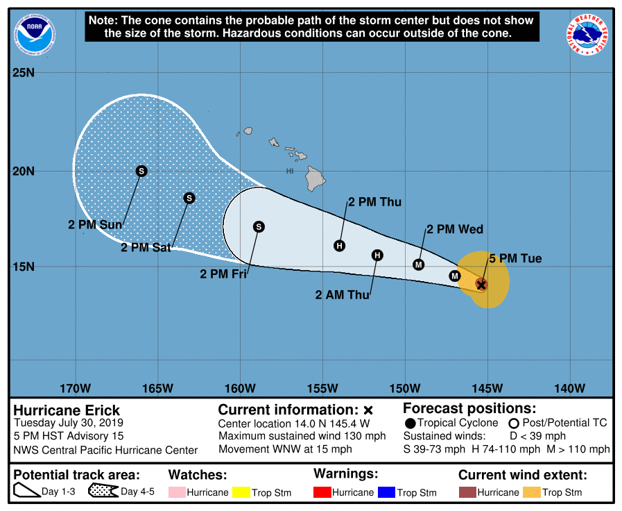
WTPA41 PHFO 310254
TCDCP1
Hurricane Erick Discussion Number 15
NWS Central Pacific Hurricane Center Honolulu HI EP062019
500 PM HST Tue Jul 30 2019
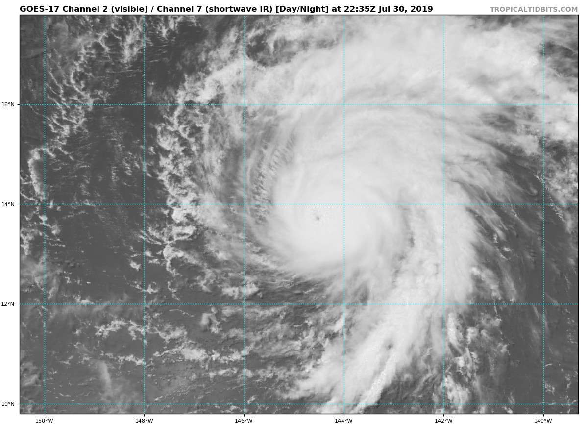
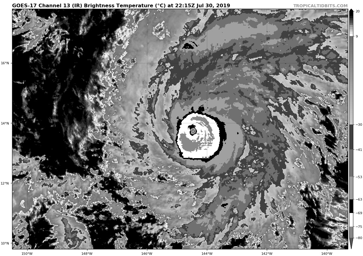
The rapid intensification of Erick has waned this afternoon, but
it still remains a powerful category 4 hurricane. Satellite images
show that the eye has become cloud-filled and elongated since the
last advisory, with outflow somewhat restricted in the southwestern
semicircle. On the other hand, outflow in the northeastern
semicircle appears optimal, and the eyewall convection has been a
prolific lightning producer through the day. Subjective Dvorak
current intensity estimates range from 6.0/115 kt from SAB/PHFO to
6.5/127 kt from PGTW, while ADT is also now near 6.0. The initial
intensity estimate for this advisory has been held at 115 kt.
A gradual turn toward the west-northwest has taken place today, and
the initial motion estimate for this advisory is 290/13 kt. There
is not much change to the ongoing track forecast philosophy, and
only minor changes were made to the official forecast, despite
increasing model spread in the later forecast periods. A track
toward the west-northwest is expected over the next 24 hours or so,
with a subtle turn toward the west on days 2 and 3, before a turn
back to the west-northwest occurs on days 4 and 5. Initially, the
strong hurricane will be steered by the deep-layer flow, with
southwest winds in the upper levels helping Erick to gain latitude.
As these winds shear the cyclone, it is expected to become
increasingly shallow, steered by a low- to mid-level ridge to the
north, which will induce the westward track. As the weakened cyclone
reaches the western edge of the ridge on days 4 and 5, it is
expected to resume a motion toward the west-northwest, but forecast
models disagree as to the extent of the poleward motion. The
official forecast lies closest to HCCA guidance, with the 5 day
forecast point almost on top of the UKMET ensemble guidance.
The window for further intensification appears to be closing, as
increased vertical wind shear (20 kt increasing to 40 kt) lies
along the forecast track, especially after about 24 hours. Once
Erick encounters this southwesterly to westerly shear, associated
with a semi-permanent trough aloft northwest of Hawaii, significant
weakening is expected. In the meantime, Erick is expected to change
little, but it wouldn't be surprising to see the eye clear out again
overnight. The updated intensity forecast closely follows HCCA and
FSSE guidance.
An 1845Z partial ASCAT pass was used to expand 34 kt wind radii,
mainly in the northern semicircle.
FORECAST POSITIONS AND MAX WINDS
INIT 31/0300Z 14.0N 145.4W 115 KT 130 MPH
12H 31/1200Z 14.5N 147.0W 115 KT 130 MPH
24H 01/0000Z 15.1N 149.2W 100 KT 115 MPH
36H 01/1200Z 15.6N 151.7W 90 KT 105 MPH
48H 02/0000Z 16.1N 154.0W 70 KT 80 MPH
72H 03/0000Z 17.1N 158.9W 40 KT 45 MPH
96H 04/0000Z 18.6N 163.1W 35 KT 40 MPH
120H 05/0000Z 20.0N 166.0W 35 KT 40 MPH
$$
Forecaster Birchard
|
|