開啟輔助訪問
 找回密碼
 立即加入

05L.Elsa 登陸美國佛州 轉化溫氣

簽到天數: 1650 天

[LV.Master]伴壇終老

老農民版夜神月|2021-7-2 05:07 | 顯示全部樓層
後期或將直襲美國
205258_5day_cone_no_line_and_wind.png natl (1).png
05L_gefs_latest.png 05L_tracks_latest.png
05L_intensity_latest.png
回復

使用道具 舉報

簽到天數: 483 天

[LV.9]以壇為家II

dom|2021-7-2 20:33 | 顯示全部樓層
實測達標,NHC升格C1
823
WTNT45 KNHC 021223
TCDAT5

Hurricane Elsa Special Discussion Number   8
NWS National Hurricane Center Miami FL       AL052021
830 AM AST Fri Jul 02 2021

Surface observations from Barbados indicate that Elsa has become a
hurricane, and this special advisory is being issued to update the
first 36 h of the intensity and wind radii forecasts.  More
revisions of the intensity forecast are likely on the next regular
advisory.  An Air Force Reserve Hurricane Hunter aircraft is
currently entering the hurricane, and a NOAA aircraft is scheduled
to investigate the system this afternoon.

There are no changes to the forecast track at this time.  It should
be noted that the average NHC track errors are 175 miles and 200
miles at days 4 and 5, respectively.  Given the larger-than-normal
uncertainty and because hazards will extend well away from the
center of the storm, users are urged to not focus on the exact
forecast points.

Key Messages:

1. Hurricane conditions are occurring on Barbados and are expected
elsewhere in the Hurricane Warning area in the next few hours.  
Tropical storm conditions are expected to begin later this morning
in other portions of the Windward and Leeward Islands. Tropical
storm conditions are expected and hurricane conditions are possible
over southern portions of Hispaniola on Saturday. Tropical storm
conditions are possible over Jamaica beginning Saturday night.

2. Heavy rainfall from Elsa will move quickly across the Windward
and southern Leeward Islands today, including Barbados. Outer rain
bands will impact Puerto Rico late today into Saturday, and southern
Hispaniola and Jamaica Saturday into Sunday. Flooding and mudslides
are possible.

3. There is a risk of wind and rainfall impacts in portions of
Cuba, the Turks and Caicos, and the Bahamas through early next
week. Interests in these areas should monitor Elsa's progress and
updates to the forecast.

4. There is a risk of storm surge, wind, and rainfall impacts in the
Florida Keys and portions of the Florida Peninsula early next week.
However, the forecast uncertainty remains larger than usual due to
Elsa's potential interaction with the Greater Antilles this weekend.
Interests in Florida should monitor Elsa's progress and updates to
the forecast.


FORECAST POSITIONS AND MAX WINDS

INIT  02/1230Z 13.1N  60.1W   65 KT  75 MPH
12H  02/1800Z 13.8N  62.4W   65 KT  75 MPH
24H  03/0600Z 15.4N  67.4W   65 KT  75 MPH
36H  03/1800Z 17.1N  71.7W   65 KT  75 MPH
48H  04/0600Z 18.7N  75.2W   60 KT  70 MPH
60H  04/1800Z 20.2N  77.8W   55 KT  65 MPH
72H  05/0600Z 21.7N  79.7W   55 KT  65 MPH
96H  06/0600Z 25.2N  82.2W   55 KT  65 MPH
120H  07/0600Z 29.2N  82.6W   55 KT  65 MPH

$$
Forecaster Beven

D21EFED4-C21F-4140-866D-D95C4BE97D12.png 085F164B-5116-4951-99F7-FBB96CE65BFC.png
回復

使用道具 舉報

簽到天數: 1650 天

[LV.Master]伴壇終老

老農民版夜神月|2021-7-3 08:14 | 顯示全部樓層
經由實測,NHC進一步將定強調升至75節
317
WTNT45 KNHC 022055
TCDAT5

Hurricane Elsa Discussion Number  10
NWS National Hurricane Center Miami FL       AL052021
500 PM AST Fri Jul 02 2021

Reports from a NOAA Hurricane Hunter aircraft indicate that Elsa
has strengthened a little more since the last advisory, with a
combination of flight-level winds, SFMR surface wind estimates, and
dropsonde data showing that the maximum winds are near 75 kt.  The
aircraft also reported that the 700-mb circulation remains somewhat
disorganized, and that the 700-mb center is not vertically aligned
with with the surface center.  The former issue is likely due to
the rapid motion, and the latter may be due to the effects of
westerly shear.

The initial motion now is 290/26.  There is again little change to
the forecast track or the forecast guidance.  The guidance is in
good agreement on a rapid west-northwestward notion to near the
south coast of the Dominican Republic and Haiti by 24-30 h, followed
by a continued west-northwestward motion at a slower forward speed
through 48 h.  After that time, Elsa should gradually turn
northwestward and eventually northward as it moves through a
weakness in the subtropical ridge created by a mid-latitude trough
over the eastern United States.  This motion should take the
cyclone across Cuba and over the eastern Gulf of Mexico or the
nearby Florida Peninsula, eventually moving into the southeastern
United States by the end of the period.  The track guidance is a
little less divergent than earlier, but there is still enough spread
in the potential tracks that this part of the forecast remains low
confidence.

The latest global model runs and the associated intensity guidance
are forecasting a less favorable environment for Elsa during the
next several days.  The SHIPS model now calls for 10-20 kt of
northwesterly shear during the next 48 h, and 15-25 kt of shear
after 60 h.  In addition, the 12Z GFS forecasts a considerably
weaker storm than its last several runs.  The intensity forecast
thus calls for little change in strength during the first 24 h,
although it is possible the hurricane could strengthen a little more
during that time.  After that, land interaction and shear are
likely to cause weakening until Elsa emerges into the Gulf of
Mexico.  However, the HWRF still calls for Elsa to intensify into a
Category 3 hurricane, and like the track forecast the intensity
forecast remains of low confidence due to the spread in the
guidance.

It should be noted that the average NHC track errors are 175 miles
and 200 miles at days 4 and 5, respectively.  Given the
larger-than-normal uncertainty and because hazards will extend well
away from the center of the storm, users are urged to not focus on
the exact forecast points.

Key Messages:

1. Hurricane conditions and dangerous storm surge are expected
within the Hurricane Warning areas in Haiti and the Dominican
Republic beginning Saturday and in Jamaica beginning Sunday.

2. Heavy rainfall will gradually subside across the Windward and
southern Leeward Islands tonight, including Barbados. Outer rain
bands will impact Puerto Rico by late tonight, and affect southern
Hispaniola and Jamaica Saturday into Sunday. Isolated to scattered
flash flooding and mudslides are possible. By early next week, heavy
rain will impact the Cayman Islands and Cuba. Significant flooding
and mudslides are possible.

3. Hurricane conditions and dangerous storm surge are possible in
portions of eastern Cuba beginning early Sunday where a Hurricane
Watch is in effect. There is an increasing risk of wind, storm
surge, and rainfall impacts elsewhere in Cuba Sunday and Monday.

4. There is an increasing risk of storm surge, wind, and rainfall
impacts beginning Monday in the Florida Keys and spreading northward
along the Florida Peninsula through Tuesday. However, the forecast
uncertainty remains larger than usual due to Elsa's potential
interaction with the islands of Hispaniola and Cuba this weekend.
Interests throughout Florida should monitor Elsa's progress and
updates to the forecast.

FORECAST POSITIONS AND MAX WINDS

INIT  02/2100Z 14.2N  63.7W   75 KT  85 MPH
12H  03/0600Z 15.4N  67.5W   75 KT  85 MPH
24H  03/1800Z 17.0N  71.7W   75 KT  85 MPH
36H  04/0600Z 18.3N  74.8W   70 KT  80 MPH
48H  04/1800Z 19.9N  77.3W   70 KT  80 MPH...INLAND
60H  05/0600Z 21.4N  79.4W   65 KT  75 MPH...OVER WATER
72H  05/1800Z 22.9N  81.1W   55 KT  65 MPH...INLAND
96H  06/1800Z 26.5N  83.0W   55 KT  65 MPH...OVER WATER
120H  07/1800Z 31.6N  82.0W   40 KT  45 MPH...INLAND

$$
Forecaster Beven
205743_5day_cone_no_line_and_wind.png al052021 (4).gif
20211832040_GOES16-ABI-FL-GEOCOLOR-AL052021-1000x1000.jpg 20210702.2340.goes-16.ir.05L.ELSA.75kts.991mb.13.8N.62.4W.100pc.jpg
回復

使用道具 舉報

簽到天數: 483 天

[LV.9]以壇為家II

dom|2021-7-3 16:51 | 顯示全部樓層
NHC09Z判定其已達到巔峰,定強降至65KT
000
WTNT45 KNHC 030838
TCDAT5

Hurricane Elsa Discussion Number  12
NWS National Hurricane Center Miami FL       AL052021
500 AM AST Sat Jul 03 2021

Elsa appears less organized this morning.  Satellite images show an
asymmetric cloud pattern with the low-level center located near the
northwestern edge of the main area of thunderstorms.  This satellite
presentation is indicative of moderate-to-strong northwesterly
shear that is likely caused by the tropical cyclone's fast forward
motion. The initial intensity is lowered to 65 kt following a blend
of the latest Dvorak estimates. The hurricane passed by NOAA buoy
42059 a few hours ago, and the storm's minimum pressure was
adjusted a few millibars higher based on the buoy's data. Another
Air Force Hurricane Hunter aircraft will be flying through Elsa in
a couple of hours, and the data the plane collects will provide a
better estimate of Elsa's intensity and structure.

Elsa continues to move very quickly to the west-northwest at about
27 kt.  A subtropical ridge to the north of the hurricane should
keep it on a west-northwest path, albeit at a slightly slower pace
through the weekend.  This should take the core of the storm just
south of or over southern Hispaniola later today and near or
across Jamaica and eastern Cuba on Sunday.  Shortly after that time,
Elsa is expected to near the western edge of the ridge and move
toward a weakness over the southeastern U.S.  In response to this
pattern change, Elsa should slow down some more and turn to the
north.  The models appear to be slowly converging on a solution in
showing the cyclone making the northward turn somewhere over Cuba on
Monday and then heading in the vicinity of Florida or the
eastern Gulf of Mexico late Monday through Wednesday. Although the
models are in better agreement compared to previous days, there is
still a considerable amount of spread in the GFS and ECMWF ensemble
members, and the details of the long-term track are still uncertain.

Some mid-level wind shear associated with Elsa's fast forward speed
appears to be affecting the hurricane now.  However, since the
cyclone is expected to slow down and move beneath an upper-level
anticyclone later this weekend, it seems likely that the vortex will
become better aligned in the vertical.  The big question is will
Elsa be interacting with the mountainous islands of Hispaniola and
Cuba when the environmental winds become conducive for
strengthening.  If the cyclone manages to stay south of those
islands, Elsa could have an opportunity to restrengthen. Conversely,
if the storm tracks directly over the islands, weakening would very
likely occur.  As a compromise, the NHC intensity forecast shows
little change in strength through tonight, followed by slow
weakening on Sunday and early Monday.  Slight restrengthening is
forecast when Elsa moves north of Cuba and  across the eastern Gulf
of Mexico.  This forecast is a little lower than the previous one in
the short term, but is largely unchanged at the longer forecast
times.

Given that there is still uncertainty in the track forecast and the
degree of land interaction with Hispaniola and Cuba, users are
urged to factor in some of this uncertainty.  For reference,
average NHC track errors at days 3 and 4 are 125 miles and 150
miles, respectively.  The average NHC intensity errors are around 15
mph for both days 3 and 4.

Key Messages:

1. Hurricane conditions and dangerous storm surge are expected
within the Hurricane Warning areas in Haiti and the Dominican
Republic later today and in Jamaica beginning Sunday.

2. Widespread heavy rain will move across southern Hispaniola and
Jamaica today into Sunday where isolated to scattered flash flooding
and mudslides will be possible. Heavy rain will then impact the
Cayman Islands and Cuba Sunday into Monday resulting in significant
flooding with mudslides in Cuba. As Elsa approaches the Florida Keys
and southern Florida early next week, isolated flash flooding and
minor river flooding will be possible.

3. Hurricane conditions and dangerous storm surge are possible in
portions of eastern Cuba beginning early Sunday where a Hurricane
Watch is in effect. There is an increasing risk of wind, storm
surge, and rainfall impacts elsewhere in Cuba Sunday and Monday.

4. There is an increasing risk of storm surge, wind, and rainfall
impacts beginning Monday in the Florida Keys and spreading northward
along the Florida Peninsula through Tuesday. However, the forecast
uncertainty remains larger than usual due to Elsa's potential
interaction with the islands of Hispaniola and Cuba this weekend.
Interests throughout Florida should monitor Elsa's progress and
updates to the forecast.


FORECAST POSITIONS AND MAX WINDS

INIT  03/0900Z 16.2N  69.0W   65 KT  75 MPH
12H  03/1800Z 17.5N  72.3W   65 KT  75 MPH
24H  04/0600Z 19.0N  75.4W   65 KT  75 MPH
36H  04/1800Z 20.5N  77.8W   60 KT  70 MPH
48H  05/0600Z 22.1N  79.7W   55 KT  65 MPH...INLAND
60H  05/1800Z 23.4N  81.2W   50 KT  60 MPH...OVER WATER
72H  06/0600Z 24.7N  82.2W   55 KT  65 MPH
96H  07/0600Z 28.2N  83.0W   55 KT  65 MPH
120H  08/0600Z 33.7N  80.2W   35 KT  40 MPH...INLAND

$$
Forecaster Cangialosi/Berg
F71F8127-7F6E-4B15-A7EB-F624B314E7FB.png
回復

使用道具 舉報

簽到天數: 483 天

[LV.9]以壇為家II

dom|2021-7-3 23:24 | 顯示全部樓層
NHC15Z降格TS,預測可能於一天內登陸多米尼加
000
WTNT45 KNHC 031501
TCDAT5

Tropical Storm Elsa Discussion Number  13
NWS National Hurricane Center Miami FL       AL052021
1100 AM EDT Sat Jul 03 2021

Reports from an Air Force Reserve Hurricane Hunter aircraft and
satellite imagery indicate that Elsa has weakened some since the
last advisory.  The aircraft reported maximum 700-mb flight-level
winds of 64 kt well to the northeast of the center, and maximum
surface winds estimates from the SFMR  of about 55 kt.  The
aircraft-reported central pressure is near 999 mb and gradually
rising,  In addition, the center was exposed for a few hours,
although it is now located at the northwestern edge of a new
convective burst.  Based on the aircraft data, the initial intensity
is reduced to 60 kt.

The initial motion is now 295/25.  Elsa is approaching a weakness in
the subtropical ridge caused by a large baroclinic trough over the
eastern United States.  The global models forecast this trough to
move eastward into the Atlantic, but the southern portion is likely
to split off and become an upper-level low pressure area over the
western Gulf of Mexico, with the subtropical ridge over the Atlantic
situated to the east of the this low.  This evolution should cause
Elsa to slow its current breakneck forward speed during the next day
or so, then turn northwestward between 36-60 h, followed by a
general northward motion from 72-96 h and recurvature into the
westerlies after that time.  The track guidance is in much better
agreement than this time yesterday, and Elsa is expected to pass
near or over southwestern Haiti, Cuba, and the eastern Gulf of
Mexico or the Florida Peninsula during the next 3 days or so.  After
that, the system is likely to cross portions of the southeastern
United States on its way into the Atlantic.  The new NHC forecast
track has only minor adjustments from the previous one, and it lies
near the various consensus models.

Elsa continues to be affected by northwesterly shear that is at
least partly due to the fast forward motion.  While the forward
speed is forecast to decrease over the next few days, continued
westerly shear and land interaction are expected to cause additional
weakening.  Indeed, by 60 h, the GFS, UKMET, and ECMWF show Elsa as
a weak system with some separation between the low- and mid-level
centers.  While some shear is likely to continue when the storm is
near or over the eastern Gulf of Mexico, upper-level divergence
associated with the aforementioned upper-level low could allow for
some re-intensification.  The new NHC intensity forecast calls for
more weakening in the first 48 h than previously forecast and then
shows re-intensification over the Gulf of Mexico.  Through the first
72 h, the forecast is at the upper edge of the intensity guidance.

Although Elsa is now a tropical storm, hurricane warnings remain in
effect for portions of the Dominican Republic and Haiti at this
time, as conditions have not yet reached their worst there and the
possibility that a short-lived re-intensification might occur due
to a convective burst.

Given that there is still uncertainty in the track forecast and the
degree of land interaction with Hispaniola and Cuba, users are
urged to factor in some of this uncertainty.  For reference, average
NHC track errors at days 3 and 4 are 125 miles and 150 miles,
respectively.  The average NHC intensity errors are around 15 mph
for both days 3 and 4.

Key Messages:

1. A hurricane warning remains in effect for portions of Haiti and
the Dominican Republic, where near-hurricane conditions and
dangerous storm surge are expected through this evening.

2. Widespread heavy rain will move across southern Hispaniola and
Jamaica today into Sunday where isolated to scattered flash flooding
and mudslides will be possible. Heavy rain will impact the Cayman
Islands and Cuba Sunday into Monday, resulting in significant
flooding and mudslides over Cuba. As Elsa approaches the Florida
Keys and southern Florida early next week, isolated flash flooding
and minor river flooding will be possible.

3. Tropical storm conditions and dangerous storm surge are expected
with hurricane conditions possible in portions of eastern Cuba
beginning early Sunday, with tropical storm conditions possible in
central Cuba Sunday night and Monday.

4. There is an increasing risk of tropical storm conditions, storm
surge, and rainfall impacts beginning Monday in the Florida Keys and
the southern Florida Peninsula. This risk will spread northward
along the Florida Peninsula through Wednesday and reach the coasts
of Georgia and the Carolinas Wednesday and Thursday, however
uncertainty in the forecast remains larger than usual due to Elsa's
potential interaction with the islands of Hispaniola and Cuba.
Interests in Florida and along the southeast U.S. coast should
monitor Elsa's progress and updates to the forecast.

FORECAST POSITIONS AND MAX WINDS

INIT  03/1500Z 17.0N  71.6W   60 KT  70 MPH
12H  04/0000Z 18.1N  74.0W   60 KT  70 MPH
24H  04/1200Z 19.6N  76.7W   60 KT  70 MPH
36H  05/0000Z 21.2N  78.9W   55 KT  65 MPH
48H  05/1200Z 22.7N  80.5W   45 KT  50 MPH...INLAND
60H  06/0000Z 24.0N  81.8W   50 KT  60 MPH...OVER WATER
72H  06/1200Z 25.9N  82.5W   55 KT  65 MPH
96H  07/1200Z 30.0N  82.5W   50 KT  60 MPH...INLAND
120H  08/1200Z 35.0N  78.0W   35 KT  40 MPH...INLAND

$$
Forecaster Beven
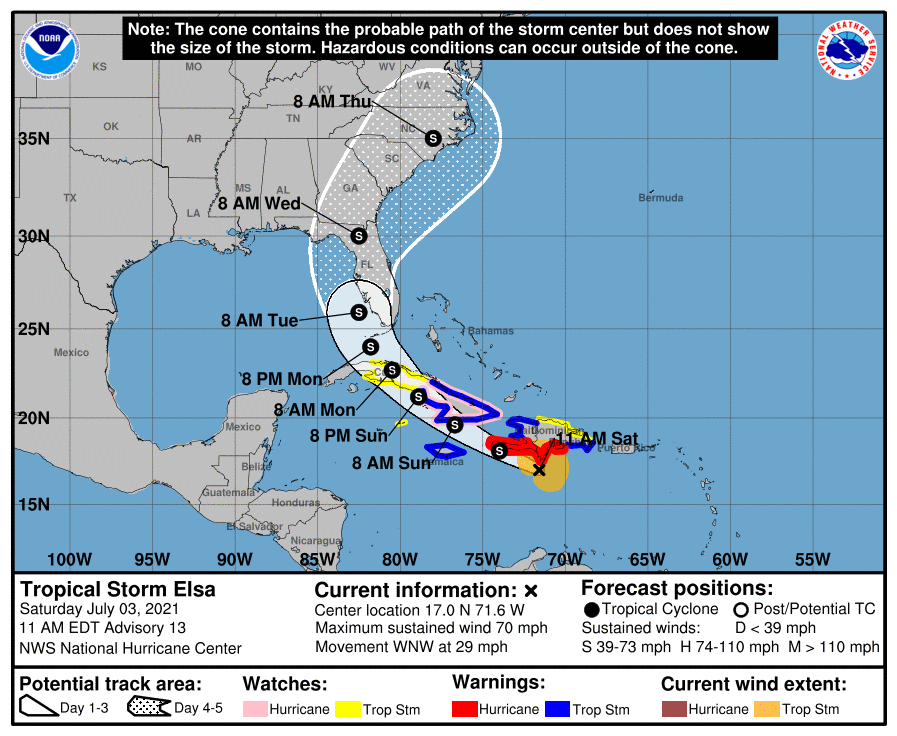
144912_5day_cone_no_line_and_wind.png
回復

使用道具 舉報

簽到天數: 483 天

[LV.9]以壇為家II

dom|2021-7-4 11:03 | 顯示全部樓層
NHC判定略過多米尼加 後期將直襲古巴和橫掃美國多個州
454
WTNT45 KNHC 040259
TCDAT5

Tropical Storm Elsa Discussion Number  15
NWS National Hurricane Center Miami FL       AL052021
1100 PM EDT Sat Jul 03 2021

Elsa is undergoing a convective bursting pattern the past few
hours, with some cold overshooting tops of -90 deg C east and
northeast of the center. However, data from an Air Force Reserve
reconnaissance aircraft indicate that this convective increase has
not translated into an intensity increase. To the contrary, 5000-ft
flight-level and SFMR surface winds have decreased while the central
pressure has increased to 1004 mb. Based on the latest recon data,
the intensity has been lowered to 55 kt. The aircraft has now
climbed to 10,000 ft for safety reasons and will be penetrating the
area of intense convection to check for stronger winds there.

The initial motion estimate is now 295/15 kt.  Elsa is forecast to
gradually move around the western periphery of a deep-layer
subtropical ridge over the next 96 hours, accompanied by an
additional decrease in forward speed. The latest model guidance has
continued to converge along the previous advisory track, with the
corrected-consensus models HCCA and FSSE nearly on top of each
other. The TCVA simple consensus model is also similar to the HCCA
and FSSE models. However, out of respect for the slightly more
westward GFS and GFS-ensemble models, which have performed
admirably thus far with Elsa, the new official forecast lies a tad
west of the aforementioned consensus models and lies nearly on top
of the previous advisory track.

After interacting with the mountainous terrain of southwestern
Haiti, which could have caused some disruption in the low-level
field despite the center remaining offshore, little change in
intensity is expected tonight. However, some slight restrengthening
could occur by Sunday afternoon as Elsa approaches the south-central
coast of Cuba where the sea-surface temperatures are quite warm at
more than 30 deg C and the water is deep. Weakening is expected
after the cyclone moves across west-central Cuba, followed again by
some slight restrengthening after Elsa emerges over the warm Gulf
Stream in the Straits of Florida. Westerly vertical wind shear
increasing to near 20 kt by 96 hours should prevent any significant
strengthening from occurring. Elsa should become a very  
asymmetrical tropical cyclone late on day 3 and on day 4 with most
of the heavy rain and strongest winds displaced along and to the
east of the forecast track. The initial intensity is similar to the
previous advisory and closely follows the simple and corrected
consensus models.

Given the remaining uncertainty in the track forecast and the degree
of land interaction with Hispaniola and Cuba, users are urged to
factor in some of this uncertainty.  For reference, average NHC
track errors at days 3 and 4 are 125 miles and 150 miles,
respectively.  The average NHC intensity errors are around 15 mph
for both days 3 and 4.

Key Messages:

1. Widespread heavy rain will move across southern Haiti and Jamaica
tonight into Sunday where isolated to scattered flash flooding and
mudslides will be possible. Heavy rain will then impact the Cayman
Islands and Cuba Sunday into Monday resulting in significant
flooding and mudslides over Cuba. As Elsa approaches the Florida
Keys and  Florida Peninsula early next week, isolated flash flooding
and minor river flooding will be possible.

2. Tropical storm conditions and dangerous storm surge are expected
with hurricane conditions possible in portions of eastern Cuba
beginning early Sunday, with tropical storm conditions possible in
central and western Cuba Sunday night and Monday.

3. There is an increasing risk of tropical storm conditions, storm
surge, and rainfall impacts beginning Monday in the Florida Keys and
the southern Florida Peninsula, and a Tropical Storm Watch is now
in effect for portions of the Florida Keys. This risk will spread
northward along the Florida Peninsula through Wednesday and reach
the coasts of Georgia and the Carolinas Wednesday and Thursday,
however uncertainty in the forecast remains larger than usual due
to Elsa's potential interaction with the islands of Hispaniola and
Cuba. Interests elsewhere in Florida and along the southeast U.S.
coast should monitor Elsa's progress and updates to the forecast.


FORECAST POSITIONS AND MAX WINDS

INIT  04/0300Z 17.9N  75.3W   55 KT  65 MPH
12H  04/1200Z 19.2N  77.3W   55 KT  65 MPH
24H  05/0000Z 20.9N  79.4W   60 KT  70 MPH
36H  05/1200Z 22.5N  81.0W   50 KT  60 MPH...INLAND
48H  06/0000Z 24.1N  82.2W   45 KT  50 MPH...OVER WATER
60H  06/1200Z 26.0N  82.8W   50 KT  60 MPH
72H  07/0000Z 28.0N  83.0W   50 KT  60 MPH
96H  08/0000Z 32.7N  81.0W   45 KT  50 MPH...INLAND
120H  09/0000Z 37.7N  74.9W   35 KT  40 MPH...OVER WATER

$$
Forecaster Stewart/Papin
9AF01128-E4BA-4E10-86B0-1AD3A8B3F507.png
回復

使用道具 舉報

簽到天數: 483 天

[LV.9]以壇為家II

dom|2021-7-6 08:38 | 顯示全部樓層
NHC判定登陸古巴
339
WTNT45 KNHC 052047
TCDAT5

Tropical Storm Elsa Discussion Number  22
NWS National Hurricane Center Miami FL       AL052021
500 PM EDT Mon Jul 05 2021

Satellite and radar imagery along with surface synoptic
observations indicate that the tropical cyclone moved inland over
west-central Cuba around 1800 UTC, accompanied by very heavy rains.
Assuming that some weakening has occurred due to the influence of
land, the advisory intensity is set to 45 kt.  An Air Force
Hurricane Hunter aircraft is scheduled to investigate Elsa this
evening after the center moves into the Florida Straits and will
provide a better assessment of the system's intensity.

The storm appears to be continuing on its northwestward track and
the initial motion estimate is 315/12 kt.  There are no changes to
the track forecast reasoning from the previous advisory.  Elsa
should move between the western portion of a mid-level subtropical
ridge extending westward from the Atlantic and a broad low pressure
area near the northwestern Gulf of Mexico coast for the next couple
of days.  Later in the forecast period, the system is likely to
accelerate northeastward and move from the eastern United States
to near Atlantic Canada.  The NHC track forecast over the eastern
Gulf of Mexico is practically identical to the one from the
previous advisory, and a little to the left of the previous one
over the eastern United States and the Atlantic.  This is in good
agreement with the now tightly-clustered track model guidance.

Some restrengthening of the cyclone is likely after it moves into
the Gulf of Mexico, but vertical shear associated with a broad
upper-level trough over the Gulf is likely to limit
intensification.  The official intensity forecast is slightly above
the latest model consensus, IVCN.  Around 96 hours, the global
models suggest that the cyclone will merge with a frontal zone, so
the forecast shows extratropical transition at that time.


Key Messages:

1. Heavy rain will impact the Cayman Islands and Cuba through
tonight resulting in significant flooding and mudslides over
Cuba. As Elsa approaches the Florida Keys, Florida Peninsula, and
southeast Georgia through Wednesday, heavy rainfall may result in
isolated flash, urban, and minor river flooding, with considerable
flooding possible in southwest and western portions of Florida.  
Mid- to late-week, heavy rains across coastal South Carolina,
North Carolina, and southeastern Virginia may result in isolated
flash and urban flooding.

2. There is a danger of life-threatening storm surge along
portions of the west coast of Florida Tuesday night and Wednesday,
and a Storm Surge Warning has been issued for that area.

3. Tropical storm conditions are expected to continue across
portions of central and western Cuba tonight, and spread northward
across portions of the Florida Keys and  the Florida west coast
through Wednesday, where a Tropical Storm Warning is in effect.

4. There is a risk of tropical storm conditions along portions of
the coasts of Georgia and the Carolinas Wednesday and Thursday.


FORECAST POSITIONS AND MAX WINDS

INIT  05/2100Z 22.7N  81.9W   45 KT  50 MPH
12H  06/0600Z 24.1N  82.7W   50 KT  60 MPH
24H  06/1800Z 26.1N  83.4W   55 KT  65 MPH
36H  07/0600Z 28.2N  83.6W   55 KT  65 MPH
48H  07/1800Z 30.6N  83.0W   35 KT  40 MPH...INLAND
60H  08/0600Z 32.8N  81.4W   30 KT  35 MPH...INLAND
72H  08/1800Z 35.5N  78.5W   30 KT  35 MPH...INLAND
96H  09/1800Z 41.5N  69.5W   40 KT  45 MPH...POST-TROP/EXTRATROP
120H  10/1800Z 49.0N  56.0W   40 KT  45 MPH...POST-TROP/EXTRATROP

$$
Forecaster Pasch
1BBD9638-0E73-4581-B776-60395EDA97F4.png
回復

使用道具 舉報

簽到天數: 3279 天

[LV.Master]伴壇終老

t02436|2021-7-6 13:52 | 顯示全部樓層
中心已出海進入墨西哥灣,預期48小時內將自佛州西部登陸。
812
WTNT45 KNHC 060250
TCDAT5

Tropical Storm Elsa Discussion Number  23
NWS National Hurricane Center Miami FL       AL052021
1100 PM EDT Mon Jul 05 2021

Radar data from Cuba and Key West, Florida, along with surface
observations, indicate that the center of Elsa is back over water,
having emerged off the northern coast of of Cuba around 0200 UTC.
Doppler velocity data from the NOAA WSR-88D at Key West indicate
values of around 55 t at 10,000 ft, which supports equivalent
surface winds of 49 kt. An Air Force reconnaissance aircraft flying
just offshore the north coast of Cuba over deep water measured
reliable SFMR surface winds of at least 50 kt. Based on these data,
the intensity has been increased to 50 kt.

The initial motion estimate is 330/10 kt. Just like over the past
three days, no significant changes have been made to the previous
track forecast or synoptic reasoning. Elsa is now moving
north-northwestward around the southwestern periphery of a
deep-layer ridge whose axis extends westward across the Atlantic to
central Florida. The cyclone should gradually move around the ridge
over the next 36 hours, turning northward on Tuesday and then
north-northeastward Tuesday night and Wednesday morning. By late
Wednesday, Elsa should accelerate northeastward ahead of a
mid-latitude trough and frontal system, moving across the eastern
United States to near Atlantic Canada. The new NHC track forecast is
very similar to the previous advisory track, but was nudged slightly
eastward due to the more eastward initial position, and lies a tad
east of of the various tightly clustered track consensus models.

Some additional strengthening is expected over the next 36 hours,
with some of the SHIPS and global models showing Elsa possibly
reaching 60 kt just before landfall along the northwestern Florida
peninsula. This would typically require a Hurricane Watch for a
small portion of northwest Florida. However, given that Elsa has
been hugging a very tight mid-level moisture gradient -- a
condition that is expected to continue until landfall occurs in
about 36 hours -- the new official intensity forecast remains
similar to the previous advisory and holds the peak intensity at 55
kt due to expected intermittent dry-air intrusions. Subsequent NHC
forecasts can assess the new reconnaissance and model data that will
be coming in later tonight, and determine if an increase in the
intensity forecast and the issuance of a hurricane watch or warning
is required. By 96 hours, the global models suggest that the
cyclone will merge with a frontal zone, so the new intensity
forecast continues to shows extratropical transition at that time.


Key Messages:

1. Heavy rain will impact the Cayman Islands and Cuba tonight
resulting in significant flooding and mudslides over Cuba. As Elsa
approaches the Florida Keys, Florida Peninsula, and southeast
Georgia through Wednesday, heavy rainfall may result in isolated
flash, urban, and minor river flooding, with considerable flooding
possible in southwest and western portions of Florida.  Mid to late
week, heavy rains across coastal South Carolina, North Carolina, and
southeastern Virginia may result in isolated flash and urban
flooding.

2. There is a danger of life-threatening storm surge along
portions of the west coast of Florida Tuesday night and Wednesday,
and a Storm Surge Warning has been issued for that area.

3. Tropical storm conditions are expected to continue across
portions of central and western Cuba tonight, and spread northward
across portions of the Florida Keys and  the Florida west coast
through Wednesday, where a Tropical Storm Warning is in effect.

4. There is a risk of tropical storm conditions along portions of
the coasts of Georgia and the Carolinas Wednesday and Thursday.


FORECAST POSITIONS AND MAX WINDS

INIT  06/0300Z 23.5N  82.3W   50 KT  60 MPH
12H  06/1200Z 24.9N  82.9W   55 KT  65 MPH
24H  07/0000Z 26.9N  83.3W   55 KT  65 MPH
36H  07/1200Z 29.2N  83.1W   55 KT  65 MPH
48H  08/0000Z 31.6N  82.0W   30 KT  35 MPH...INLAND
60H  08/1200Z 34.0N  79.8W   30 KT  35 MPH...INLAND
72H  09/0000Z 36.9N  76.1W   30 KT  35 MPH...INLAND
96H  10/0000Z 43.3N  66.0W   40 KT  45 MPH...POST-TROP/EXTRATROP
120H  11/0000Z 50.5N  52.4W   40 KT  45 MPH...POST-TROP/EXTRATROP

$$
Forecaster Stewart

053446_5day_cone_with_line.png

goes16_truecolor_05L_202107060342.gif

recon_AF301-1205A-ELSA.png
recon_AF301-1205A-ELSA_timeseries.png
回復

使用道具 舉報

快速回覆
您需要登錄後才可以回帖 登錄 | 立即加入

本版積分規則

本平台僅供學術討論之用,預報應以氣象局為準

威普網站虛擬主機贊助公司

臺灣第一個天氣類型社群平台 即時天氣資訊、精準颱風動態

線上客服
FB傳送訊息
廣告行銷
精準行銷 物超所值
官方粉專
發佈 快速回復 返回頂部 返回列表