開啟輔助訪問
 找回密碼
 立即加入

11E.Javier 逐漸減弱消散

簽到天數: 601 天

[LV.9]以壇為家II

2022-8-31 10:28 | 顯示全部樓層
本帖最後由 霧峰追風者 於 2022-9-5 10:28 編輯

基本資料  
編號    :92 E
擾動編號日期:2022 08 31 08
撤編日期  :2022 09 00 00
92E.INVEST.20kts-1007mb-13.8N-104.1W
20220831.0000.goes-17.ir.92E.INVEST.20kts.1007mb.13.8N.104.1W.100pc.jpg
1. Offshore of Southwestern Mexico:
A tropical wave located a few hundred miles south-southeast of
Manzanillo, Mexico is producing a large area of disorganized
showers and thunderstorms.  Environmental conditions are forecast
to be conducive for gradual development during the next few days,
and a tropical depression is expected to form later this week or by
this weekend. The system is forecast to move west-northwestward or
northwestward, likely remaining a few hundred miles off the coast of
southwestern Mexico.
* Formation chance through 48 hours...medium...50 percent.
* Formation chance through 5 days...high...70 percent.

two_pac_2d1.png

評分

參與人數 1水氣能量 +15 +1 收起 理由
t02436 + 15 + 1

查看全部評分

回復

使用道具 舉報

簽到天數: 601 天

[LV.9]以壇為家II

霧峰追風者|2022-9-1 10:11 | 顯示全部樓層
1. Offshore of West-Central Mexico:
Showers and thunderstorms associated with an area of low pressure
located about 300 miles west-southwest of Manzanillo, Mexico, have
become better organized today.  Although the low's circulation
remains somewhat broad and elongated, further development is
expected, and a tropical depression or tropical storm is forecast
to form during the next day or so while moving northwestward at
about 10 mph, likely remaining a couple of hundred miles off the
western coast of Baja California Sur.
* Formation chance through 48 hours...high...80 percent.
* Formation chance through 5 days...high...90 percent.
two_pac_2d1.png
回復

使用道具 舉報

簽到天數: 601 天

[LV.9]以壇為家II

霧峰追風者|2022-9-2 10:17 | 顯示全部樓層
000
WTPZ41 KNHC 012034
TCDEP1

Tropical Depression Eleven-E Discussion Number   1
NWS National Hurricane Center Miami FL       EP112022
300 PM MDT Thu Sep 01 2022

The area of low pressure that NHC has been monitoring a few hundred
miles south of the southern tip of the Baja California peninsula
has developed organized deep convection and a well-defined center.  
Therefore, the system is now being classified as a tropical
depression and the initial intensity is estimated to be 30 kt based
on recent ASCAT data and a Dvorak estimate from TAFB.  It should be
noted that the depression is quite large with its cloud field
extending several hundred miles across.

The depression is moving northwestward at 9 kt, and this motion
with some increase in forward speed is expected during the next
couple of days as the system remains steered by the western
periphery of a subtropical ridge.  After that time, the weakening
system should turn to the west within the low-level flow.  The
models are in fair agreement, and the NHC track forecast lies near
the middle of the guidance envelope.

The environmental conditions appear favorable for intensification
during the next 36 to 48 hours, however, given the sprawling nature
of the depression only slow strengthening seems likely during that
time.  Beyond a couple of days, the system is expected to track over
much cooler SSTs and into a dry and stable airmass.  These
conditions should cause the system to decay into a remnant low in
about 60 h with continued weakening forecast thereafter.  The NHC
intensity forecast is close to the HCCA and IVCN guidance.

Although the center of the system is forecast to remain a couple of
hundred miles off the Baja California coast, outer rainbands
and large swells are expected to affect portions of the southern
and central Baja California peninsula coast during the next couple
of days.


FORECAST POSITIONS AND MAX WINDS

INIT  01/2100Z 18.9N 110.5W   30 KT  35 MPH
12H  02/0600Z 19.9N 111.5W   35 KT  40 MPH
24H  02/1800Z 21.4N 112.8W   40 KT  45 MPH
36H  03/0600Z 23.1N 114.3W   45 KT  50 MPH
48H  03/1800Z 24.5N 116.6W   45 KT  50 MPH
60H  04/0600Z 25.4N 119.0W   35 KT  40 MPH...POST-TROPICAL
72H  04/1800Z 25.8N 121.8W   30 KT  35 MPH...POST-TROP/REMNT LOW
96H  05/1800Z 25.6N 126.8W   25 KT  30 MPH...POST-TROP/REMNT LOW
120H  06/1800Z 24.9N 130.4W   25 KT  30 MPH...POST-TROP/REMNT LOW

$$
Forecaster Cangialosi
203558_5day_cone_with_line_and_wind.png 20220902.0140.goes-16.ir.11E.ELEVEN.30kts.1003mb.19.3N.111W.100pc.jpg 20220901.1740.mtb.ASCAT.wind.92E.INVEST.30kts-1004mb.180N.1098W.25km.noqc.jpg


回復

使用道具 舉報

簽到天數: 601 天

[LV.9]以壇為家II

霧峰追風者|2022-9-5 10:23 | 顯示全部樓層
174
WTPZ41 KNHC 020842
TCDEP1

Tropical Storm Javier Discussion Number   3
NWS National Hurricane Center Miami FL       EP112022
300 AM MDT Fri Sep 02 2022

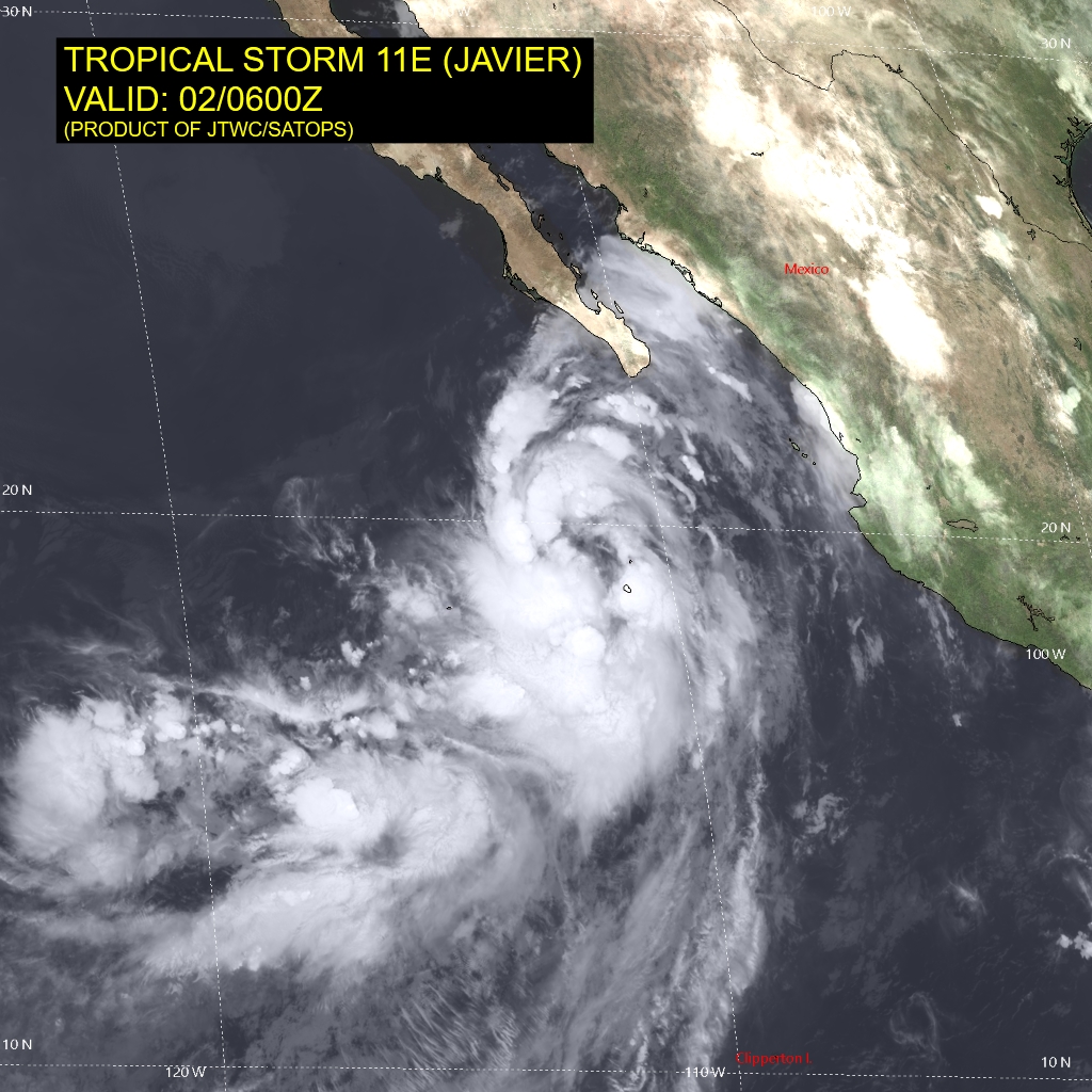
Since yesterday afternoon, deep convection has been developing over
the western half of the cyclone.  Although the surface circulation
is still elongated (north to south), deep bursts of convection
have recently appeared near the estimated center.  The latest
microwave imagery indicated curved banding with cold cloud
tops of -81C forming in the southeast quadrant.  A blend of the
subjective satellite intensity from TAFB and SAB yields an estimate
of 35 kt.  Accordingly, the depression has been upgraded to a
tropical storm for this advisory.

The depression is expected to remain in an environment conducive
for additional strengthening through Saturday, but given its
broad, elongated structure, only modest intensification is
forecast.  Afterward, gradual weakening is expected as the cyclone
traverses decreasing (22-24C) oceanic temperatures while moving
into a stable, dry marine layer.  The intensity forecast is an
update of the previous one and is based on the various intensity
consensus guidance.

Javier's initial motion is estimated to be northwestward, or 320/9
kt, moving along the western periphery of a mid-tropospheric ridge
over northern Mexico.  By the 48 hour period, the ridge as
mentioned above is expected to build westward, which should cause
the cyclone to turn toward the west-northwest and west over the
weekend.  The official track forecast is again adjusted to the
right of the previous forecast based on a mean track of the
clustered guidance, however, tropical-storm-force winds generated
by Javier are expected to remain well offshore of the western coast
of Baja California Sur.  Associated outer rainbands and large
swells are expected to affect portions of the southern and
central Baja California peninsula coast during the next couple of
days.


FORECAST POSITIONS AND MAX WINDS

INIT  02/0900Z 19.9N 111.7W   35 KT  40 MPH
12H  02/1800Z 21.2N 112.5W   40 KT  45 MPH
24H  03/0600Z 23.0N 114.1W   45 KT  50 MPH
36H  03/1800Z 24.6N 116.2W   45 KT  50 MPH
48H  04/0600Z 25.6N 118.7W   40 KT  45 MPH
60H  04/1800Z 26.1N 121.4W   35 KT  40 MPH...POST-TROPICAL
72H  05/0600Z 26.1N 123.9W   30 KT  35 MPH...POST-TROP/REMNT LOW
96H  06/0600Z 25.5N 129.2W   25 KT  30 MPH...POST-TROP/REMNT LOW
120H  07/0600Z 24.8N 133.1W   25 KT  30 MPH...POST-TROP/REMNT LOW

$$
Forecaster Roberts
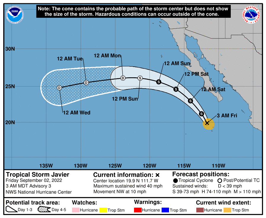
084347_5day_cone_with_line_and_wind.png 11E_020600sair.jpg
回復

使用道具 舉報

簽到天數: 601 天

[LV.9]以壇為家II

霧峰追風者|2022-9-5 10:28 | 顯示全部樓層
000
WTPZ41 KNHC 040837
TCDEP1

Post-Tropical Cyclone Javier Discussion Number  11
NWS National Hurricane Center Miami FL       EP112022
200 AM PDT Sun Sep 04 2022

There has been no significant deep convection associated with
Javier for nearly 16 hours, and it's doubtful that any
organized deep convection will attempt a comeback.  Accordingly,
Javier has become a post-tropical remnant low and this will be the
final NHC advisory on this system.  The initial intensity is
lowered to 30 kt, which is in agreement with subjective satellite
intensity estimates from TAFB and SAB.  The remnant low should
continue to gradually spin down over cooler sea surface
temperatures during the next several days, and the deterministic
models indicate that the surface circulation will become a trough
of low pressure toward the end of the week. The NHC intensity
forecast is similar to the previous one and is close to the
intensity model consensus.

The low continues to move away from the Baja California peninsula
and the initial motion estimate is 295/13 kt.  The cyclone should
turn westward soon in the low-level trade flow as a shallow remnant
low and maintain this general heading until it dissipates in 5 days.

This is the final NHC advisory on Javier.  For additional
information on the remnant low please see High Seas Forecasts
issued by the National Weather Service, under AWIPS header
NFDHSFEPI, WMO header FZPN02 KWBC, and on the web at
ocean.weather.gov/shtml/NFDHSFEPI.php


FORECAST POSITIONS AND MAX WINDS

INIT  04/0900Z 27.2N 118.5W   30 KT  35 MPH...POST-TROPICAL
12H  04/1800Z 27.8N 120.5W   30 KT  35 MPH...POST-TROP/REMNT LOW
24H  05/0600Z 27.9N 123.1W   30 KT  35 MPH...POST-TROP/REMNT LOW
36H  05/1800Z 27.6N 125.8W   25 KT  30 MPH...POST-TROP/REMNT LOW
48H  06/0600Z 27.1N 128.0W   25 KT  30 MPH...POST-TROP/REMNT LOW
60H  06/1800Z 26.8N 130.0W   20 KT  25 MPH...POST-TROP/REMNT LOW
72H  07/0600Z 26.6N 131.6W   20 KT  25 MPH...POST-TROP/REMNT LOW
96H  08/0600Z 26.5N 133.7W   20 KT  25 MPH...POST-TROP/REMNT LOW
120H  09/0600Z...DISSIPATED

$$
Forecaster Roberts
083815_5day_cone_with_line_and_wind.png
回復

使用道具 舉報

快速回覆
您需要登錄後才可以回帖 登錄 | 立即加入

本版積分規則

本平台僅供學術討論之用,預報應以氣象局為準

威普網站虛擬主機贊助公司

臺灣第一個天氣類型社群平台 即時天氣資訊、精準颱風動態

線上客服
FB傳送訊息
廣告行銷
精準行銷 物超所值
官方粉專
發佈 快速回復 返回頂部 返回列表