開啟輔助訪問
 找回密碼
 立即加入

05L.Don

簽到天數: 2095 天

[LV.Master]伴壇終老

2023-7-13 14:33 | 顯示全部樓層
本帖最後由 周子堯@FB 於 2023-7-15 22:23 編輯

  基本資料  
編號               :94 L
擾動編號日期 :2023 07 11 20
撤編日期        :2023 07 00 00

AL, 94, 2023071112,   , BEST,   0, 365N,  554W,  25, 1014, DB
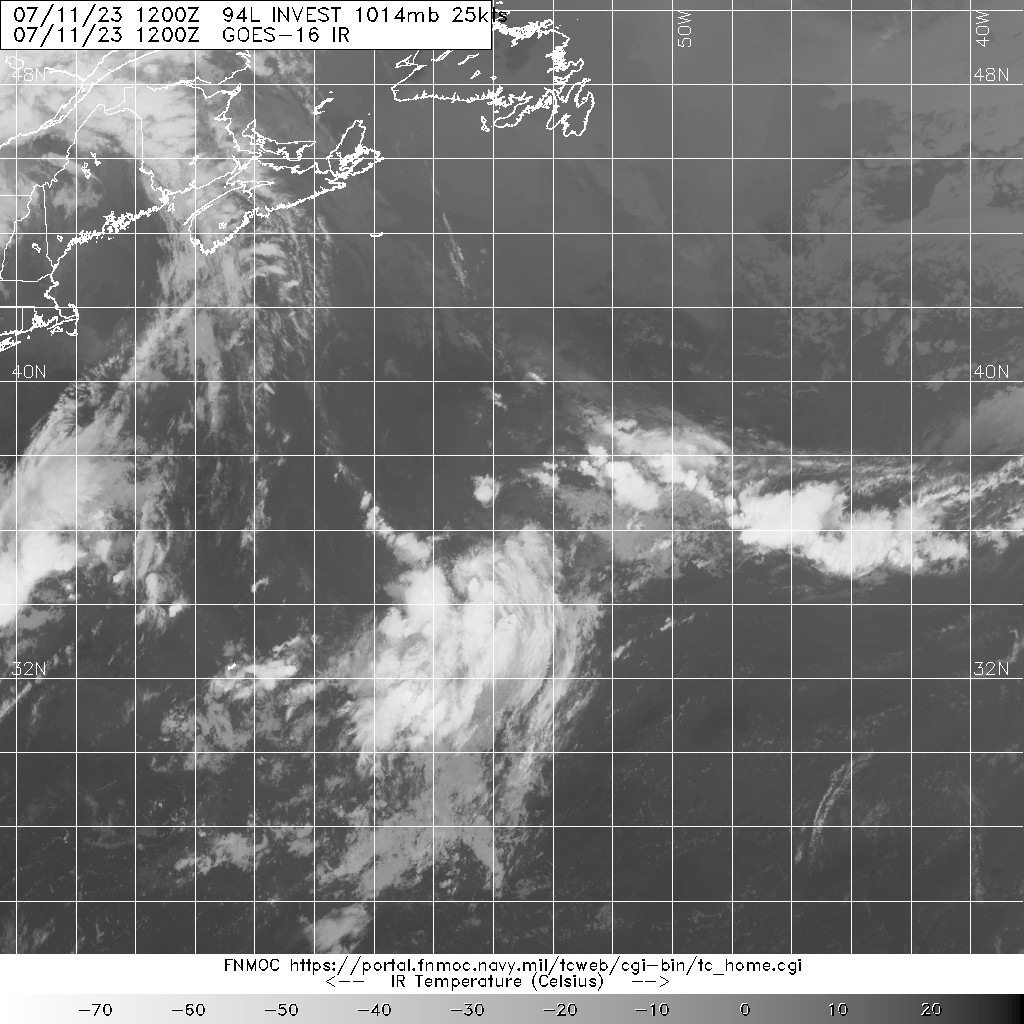
AL, 94, 2023071112,   , BEST,   0, 365N,  554W,  25, 1014, DB.jpg


NHC:30%
A trough of low pressure is producing disorganized showers and
thunderstorms a few hundred miles east-northeast of Bermuda.
Environmental conditions are forecast to be marginally conducive for
gradual development of this system, and a subtropical or tropical
depression could form on Thursday or Friday while the system moves
generally eastward. By the weekend, the low should turn northward
bringing the system over cooler waters, likely limiting additional
development.
* Formation chance through 48 hours...low...30 percent.
* Formation chance through 7 days...medium...50 percent.
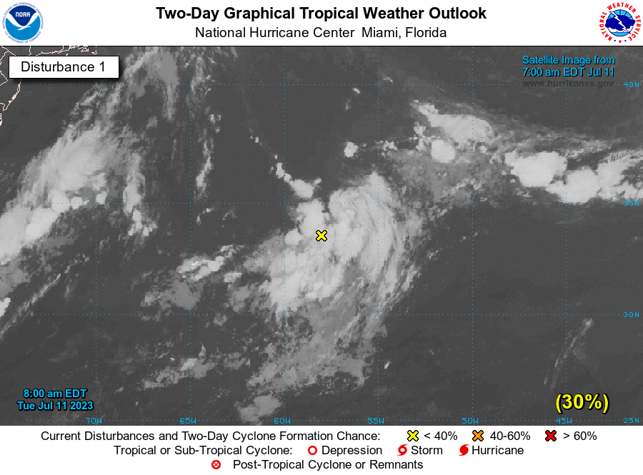
202101l4qdz4u5w41fm46q94L.png
回復

使用道具 舉報

簽到天數: 2095 天

[LV.Master]伴壇終老

周子堯@FB|2023-7-13 14:35 | 顯示全部樓層
NHC評級升至Medium 短期內成旋機率仍不高
1. Central Atlantic (AL94):
An area of low pressure located more than 800 miles east of Bermuda
continues to produce disorganized showers and thunderstorms
primarily to the east and southeast of its center. Environmental
conditions are forecast to be marginally conducive for this system
to become a subtropical depression or storm during the next couple
of days while it meanders over the central Atlantic. By the weekend,
the low should turn northward bringing the system over cooler
waters, potentially limiting additional development. Additional
information on this system, including gale warnings, can be found in
High Seas Forecasts, issued by the National Weather Service.
* Formation chance through 48 hours...medium...60 percent.
* Formation chance through 7 days...medium...60 percent.
two_atl_2d1.png


回復

使用道具 舉報

簽到天數: 2095 天

[LV.Master]伴壇終老

周子堯@FB|2023-7-14 09:59 | 顯示全部樓層
JTWC稍早發布TCFA,NHC及亦提升至High-70%,或將成旋

WTNT21 KNGU 132100
SUBJ/TROPICAL CYCLONE FORMATION ALERT//
RMKS/1. FORMATION OF A SIGNIFICANT TROPICAL CYCLONE IS POSSIBLE
WITHIN 100 NM EITHER SIDE OF A LINE FROM 31.9N 46.4W TO 33.7N 46.0W
WITHIN THE NEXT 24 HOURS. AVAILABLE DATA DOES NOT JUSTIFY
ISSUANCE OF NUMBERED TROPICAL CYCLONE WARNINGS AT THIS TIME.
WINDS IN THE AREA ARE ESTIMATED TO BE 30 TO 35 KNOTS. METSAT
IMAGERY AND RADAR DATA AT 131800Z INDICATE THAT A CIRCULATION
CENTER IS LOCATED NEAR 31.9N 47.15W. THE SYSTEM IS MOVING EAST-
NORTHEASTWARD AT 06 KNOTS.
2. REMARKS: VISIBLE SATELLITE IMAGES INDICATE THAT A BROAD AREA OF
LOW  PRESSURE LOCATED WELL EAST OF BERMUDA OVER THE CENTRAL
SUBTROPICAL ATLANTIC IS PRODUCING SOUTHERLY GALE-FORCE WINDS BUT
DOES NOT HAVE A WELL-DEFINED SURFACE CIRCULATION. ALTHOUGH
ENVIRONMENTAL CONDITIONS ARE ONLY MARGINALLY CONDUCIVE FOR FURTHER
DEVELOPMENT, ONLY A SLIGHT INCREASE IN THE ORGANIZATION OF THE
ASSOCIATED SHOWER AND THUNDERSTORM ACTIVITY WILL LEAD TO THE
FORMATION OF A SUBTROPICAL CYCLONE LATER TONIGHT OR FRIDAY MORNING.
THE SYSTEM IS EXPECTED TO MOVE VERY LITTLE THROUGH FRIDAY THEN MOVE
GENERALLY NORTHWARD OVER COOLER SEA SURFACE TEMPERATURES OVER THE
WEEKEND.
3. THIS ALERT WILL BE REISSUED, SUPERSEED BY POTENTIAL TROPICAL
CYCLONE ADVISORY, UPGRADED TO WARNING, OR CANCELLED BY 142100Z.//
al942023.20230713221843.gif
099
ABNT20 KNHC 132316
TWOAT

Tropical Weather Outlook
NWS National Hurricane Center Miami FL
800 PM EDT Thu Jul 13 2023

For the North Atlantic...Caribbean Sea and the Gulf of Mexico:

Central Atlantic (AL94):
An area of low pressure located about 1000 miles west-southwest of
the Azores has become more organized today, with increased
thunderstorm activity near a better-defined low-level center, along
with gale-force winds.  Although the environment is only marginally
conducive, this system will likely become a subtropical storm during
the next day or so as it meanders over the central Atlantic. By the
weekend, the low should turn northward, bringing the system over
cooler waters and potentially limiting further development.
Additional information on this system, including gale warnings, can
be found in High Seas Forecasts, issued by the National Weather
Service.
* Formation chance through 48 hours...high...70 percent.
* Formation chance through 7 days...high...70 percent.
072000fkppc1acco0q0ikc.png
20230714.0130.goes-16.ir.94L.INVEST.45kts.1002mb.32.7N.46.5W.100pc.jpg
回復

使用道具 舉報

簽到天數: 3279 天

[LV.Master]伴壇終老

t02436|2023-7-23 14:58 | 顯示全部樓層
繞了一圈,二次巔峰達C1
al052023.20230723030548.gif

GOES0640202320470hnIg.jpg

回復

使用道具 舉報

快速回覆
您需要登錄後才可以回帖 登錄 | 立即加入

本版積分規則

本平台僅供學術討論之用,預報應以氣象局為準

威普網站虛擬主機贊助公司

臺灣第一個天氣類型社群平台 即時天氣資訊、精準颱風動態

線上客服
FB傳送訊息
廣告行銷
精準行銷 物超所值
官方粉專
發佈 快速回復 返回頂部 返回列表