簽到天數: 4629 天 [LV.Master]伴壇終老
|
熱帶風暴
編號:02 C
名稱:Keli

基本資料
擾動編號日期:2025 年 07 月 27 日 14 時
命名日期 :2025 年 07 月 28 日 14 時
撤編日期 :2025 年 07 月 30 日 14 時
登陸地點 :無
巔峰時期資料
近中心最強風速 :35 kt ( TS )
海平面最低氣壓 :1006 毫巴
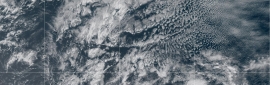
過去路徑圖 - 來源:維基百科

擾動編號資料
CP, 91, 2025072806, , BEST, 0, 119N, 1423W, 30, 1009, DB, 34, NEQ,


Tropical Weather Outlook Text
ZCZC HFOTWOCP ALL
TTAA00 PHFO DDHHMM
Tropical Weather Outlook
NWS Central Pacific Hurricane Center Honolulu HI
Issued by NWS National Hurricane Center Miami FL
200 AM HST Mon Jul 28 2025
For the central North Pacific...between 140W and 180W:
Active Systems:
The National Hurricane Center is issuing advisories on Tropical
Storm Iona, located in the central Pacific basin well southeast of
the Hawaiian Islands.
1. Eastern portion of the Central Pacific (CP91):
Shower and thunderstorm activity associated with a small low
pressure area located about 950 miles southeast of the Hawaiian
Islands is showing signs of organization and have persisted
overnight. If current trends continue, a tropical depression or
storm is likely to develop later this morning or this afternoon.
* Formation chance through 48 hours...high...80 percent.
* Formation chance through 7 days...high...80 percent.
Forecaster Brown
以上資料來自:CPHC、颱風論壇整理製作
|
評分
-
查看全部評分
|

 提升卡
提升卡 千斤頂
千斤頂 照妖鏡
照妖鏡


![91W JMA:TD[W] 熱帶低壓將通過台灣南部 留意大雨](data/attachment/block/f3/f36d9610a5027136e96e316fbd5a3bd4.jpg)