簽到天數: 3438 天 [LV.Master]伴壇終老
|
 king111807|2025-10-12 06:22
|
顯示全部樓層
king111807|2025-10-12 06:22
|
顯示全部樓層
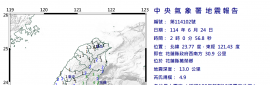
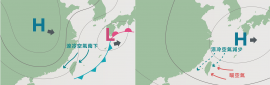
NHC判定減弱為殘餘低壓,發出最終報
483
WTNT45 KNHC 112033
TCDAT5
Remnants Of Jerry Discussion Number 18
NWS National Hurricane Center Miami FL AL102025
500 PM AST Sat Oct 11 2025
A combination of scatterometer data, GOES-East derived motion
winds, and a recent GPM microwave pass seems to confirm that Jerry
does not have a well-defined center and has degenerated into a
trough with deep convection located at the southeastern end of the
axis. As a result, this will be the last NHC advisory on this
system. Maximum winds are estimated to be 40 kt based on ASCAT data
from this morning.
The rough motion estimate is northward, or 360/14 kt. The remnant
trough is expected to move northward and then northeastward, with
the European, Canadian, and UKMET models showing it merging with a
frontal boundary to its north in 24-36 hours. Gale-force winds are
likely to continue to the east and north of the trough until it
merges with the front. The GFS continues to keep the remnants as a
distinct feature, but given that its initial position of the
remnants is too far to the southeast, it is still considered an
outlier solution.
Additional information on this system can be found in High Seas
Forecasts issued by the National Weather Service, under AWIPS
header NFDHSFAT1, WMO header FZNT01 KWBC, and online at
ocean.weather.gov/shtml/NFDHSFAT1.php
FORECAST POSITIONS AND MAX WINDS
INIT 11/2100Z 27.6N 63.6W 40 KT 45 MPH
12H 12/0600Z...DISSIPATED
$$
Forecaster Berg 

|
|

 照妖鏡
照妖鏡