Offshore Southern and Southwestern Mexico:
A trough of low pressure located well offshore of southwestern
Mexico is producing a large area of disorganized showers and
thunderstorms. Environmental conditions appear conducive for
development of this system, and a tropical depression is likely to
form late this weekend or early next week. The disturbance is
forecast to move slowly northeastward or northward near the coast
of southern Mexico. Interests in southern Mexico should monitor
the progress of this system.
* Formation chance through 48 hours...medium...40 percent.
* Formation chance through 7 days...high...70 percent.
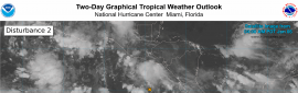
Offshore Southern and Southwestern Mexico (EP91):
A broad area of low pressure located a few hundred miles southwest
of Zihuatanejo, Mexico is producing a large area of showers and
thunderstorms. Environmental conditions appear conducive for
development of this system, and a tropical depression is likely to
form late this weekend or early next week. The disturbance is
forecast to move northeastward then northward near the coast of
southern Mexico. Interests in southern Mexico should monitor the
progress of this system. Regardless of development, locally heavy
rainfall is possible across portions of southern Mexico through
early next week.
* Formation chance through 48 hours...medium...50 percent.
* Formation chance through 7 days...high...70 percent.
Offshore Southern and Southwestern Mexico (EP91):
A broad area of low pressure located a few hundred miles southwest
of Zihuatanejo, Mexico, is producing a large area of showers and
thunderstorms. Environmental conditions appear conducive for
development of this system, and a tropical depression is likely to
form late this weekend or early next week. The disturbance is
forecast to move northeastward and then northward near the coast of
southern Mexico during the next few days. Interests in southern
Mexico should monitor the progress of this system. Regardless of
development, locally heavy rainfall is possible across portions of
southern Mexico through early next week.
* Formation chance through 48 hours...medium...60 percent.
* Formation chance through 7 days...high...70 percent.
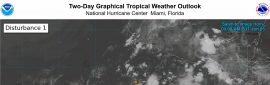
Offshore Southern and Southwestern Mexico (EP91):
A broad area of low pressure located a few hundred miles southwest
of Zihuatanejo, Mexico, is producing a large area of showers and
thunderstorms. Environmental conditions appear conducive for
development of this system, and a tropical depression is likely to
form late this weekend or early next week. The disturbance is
forecast to move northeastward and then northward near the coast of
southern Mexico during the next few days. Interests in southern
Mexico should monitor the progress of this system. Regardless of
development, locally heavy rainfall is possible across portions of
southern Mexico through early next week.
* Formation chance through 48 hours...high...70 percent.
* Formation chance through 7 days...high...70 percent.
WTPN21 PHNC 060230
MSGID/GENADMIN/JOINT TYPHOON WRNCEN PEARL HARBOR HI//
SUBJ/TROPICAL CYCLONE FORMATION ALERT (INVEST 91E)//
RMKS/
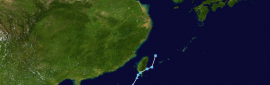
1. FORMATION OF A SIGNIFICANT TROPICAL CYCLONE IS POSSIBLE WITHIN
090 NM EITHER SIDE OF A LINE FROM 14.0N 104.3W TO 14.3N 100.6W
WITHIN THE NEXT 12 TO 24 HOURS. AVAILABLE DATA DOES NOT JUSTIFY
ISSUANCE OF NUMBERED TROPICAL CYCLONE WARNINGS AT THIS TIME.
WINDS IN THE AREA ARE ESTIMATED TO BE 18 TO 23 KNOTS. METSAT
IMAGERY AT 060000Z INDICATES THAT A CIRCULATION CENTER IS LOCATED
NEAR 14.0N 104.2W. THE SYSTEM IS MOVING EASTWARD AT 01 KNOTS.
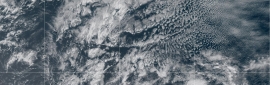
2. REMARKS: AN AREA OF CONVECTION (INVEST 91E) IS LOCATED NEAR 14.0N
104.2W, APPROXIMATELY 300NM SOUTHWEST OF ACAPULCO,MEXICO. ANIMATED
ENHANCED MULTISPECTRAL SATELLITE IMAGERY DEPICTS DEEP CONVECTION
BUILDING OVER THE LOW-LEVEL CIRCULATION CENTER. ENVIRONMENTAL ANALYSIS
DEPICTS A MARGINALLY FAVORABLE ENVIRONMENT CHARACTERIZED BY WARM SEA
SURFACE TEMPERATURES RANGING FROM 30-31 DEGREES CELSIUS AND GOOD
POLEWARD OUTFLOW, OFFSET BY MODERATE TO HIGH (20-25 KTS) SOUTHWESTERLY
VERTICAL WIND SHEAR. GLOBAL DETERMINISTIC MODELS ARE IN GOOD AGREEMENT
WITH THE EXCEPTION OF ECMWF, WHICH DEPICTS A POORLY DEFINED CIRCULATION
FORMING LATER THAN OTHER GLOBAL DETERMINISTIC MODELS. ENSEMBLE MODELS
AGREE ON A GRADUAL FORMATION OVER THE NEXT 24 HOURS, WITH A GENERALLY
NORTHEASTWARD TRACK. MAXIMUM SUSTAINED SURFACE WINDS ARE ESTIMATED AT 18
TO 23 KNOTS. MINIMUM SEA LEVEL PRESSURE IS ESTIMATED TO BE NEAR 1005 MB.
THE POTENTIAL FOR THE DEVELOPMENT OF A SIGNIFICANT TROPICAL CYCLONE
WITHIN THE NEXT 24 HOURS IS HIGH.
3. THIS ALERT WILL BE REISSUED, UPGRADED TO WARNING OR CANCELLED BY
070230Z.//
NNNN


 提升卡
提升卡 千斤頂
千斤頂 照妖鏡
照妖鏡