簽到天數: 815 天 [LV.10]以壇為家III
|
 martin191919|2014-2-4 16:40
|
顯示全部樓層
martin191919|2014-2-4 16:40
|
顯示全部樓層
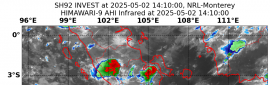
Potential Cyclones:
At 1:00 pm EST [12:30 pm CST] Tuesday 4 February, Ex-Tropical Cyclone Fletcher
was located over land, near the far southeast Gulf of Carpentaria at 16.9S
141.3E, about 80 northeast of Karumba, Queensland. Refer to the latest tropical
cyclone warnings for further details [www.bom.gov.au/cyclone]. This low is
expected to move west southwest over the far southeast Gulf of Carpentaria
later today and may briefly redevelop into a tropical cyclone overnight
Tuesday, before moving across the Queensland Gulf Country during Wednesday,
then further west over the eastern Roper-McArthur or Barkly District of the
Northern Territory later on Wednesday or Thursday. This low is expected to
weaken as it moves inland and will weaken within the monsoon trough by Friday.
Likelihood of this low being a tropical cyclone in the Northern Region on:
Wednesday Moderate
Thursday Low
Friday Low
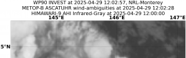
At 12:30 pm CST Tuesday 4 February, another tropical low, 996 hPa, was located
near 15.5S 132.3E, about 100 km west of Larrimah and moving east southeast at
14 km/h. This low is expected to continue moving east southeast to be located
over the Roper-McArthur District during Wednesday, then remain slow moving over
the eastern Roper-McArthur District during Thursday and Friday. By Saturday,
this low is expected to move west again. Although the low is expected to remain
over land, there is a possibility the low will move over the southwest Gulf of
Carpentaria on Thursday or Friday as it interacts with Ex-Tropical Cyclone
Fletcher, prior to recurving back to the west. For this reason, there is a
moderate risk that the low may develop into a tropical cyclone.
Likelihood of this low being a tropical cyclone in the Northern Region on:
Wednesday Low
Thursday Moderate
Friday Moderate |
|