開啟輔助訪問
 找回密碼
 立即加入

13E.Lester 長途跋涉達兩周生命史 數次增強減弱

簽到天數: 3279 天

[LV.Master]伴壇終老

t02436|2016-8-30 13:25 | 顯示全部樓層
03Z正報維持評價120節,叩關C4
000
WTPZ43 KNHC 300236
TCDEP3

HURRICANE LESTER DISCUSSION NUMBER  22
NWS NATIONAL HURRICANE CENTER MIAMI FL       EP132016
800 PM PDT MON AUG 29 2016

Lester is a powerful category 4 hurricane.  The eye of the
hurricane, which is now about 20 n mi wide, has expanded and cleared
out during the last several hours.  Visible satellite images also
indicate that mesovorticies exist within the eye.  The convective
pattern has been very symmetric, and the hurricane continues to have
an annular appearance in satellite images. The latest Dvorak
classifications from TAFB and SAB were 6.5/127 kt and 5.5/102 kt,
respectively.  Based on these estimates and automated Dvorak values
from CIMSS at the University of Wisconsin, the initial wind speed
is raised a little to 120 kt.  Lester is estimated to have
strengthened at an impressive rate of 45 kt during the past 24
hours.

The major hurricane is likely near its peak intensity, but
fluctuations in strength are possible in the short term.  Beyond
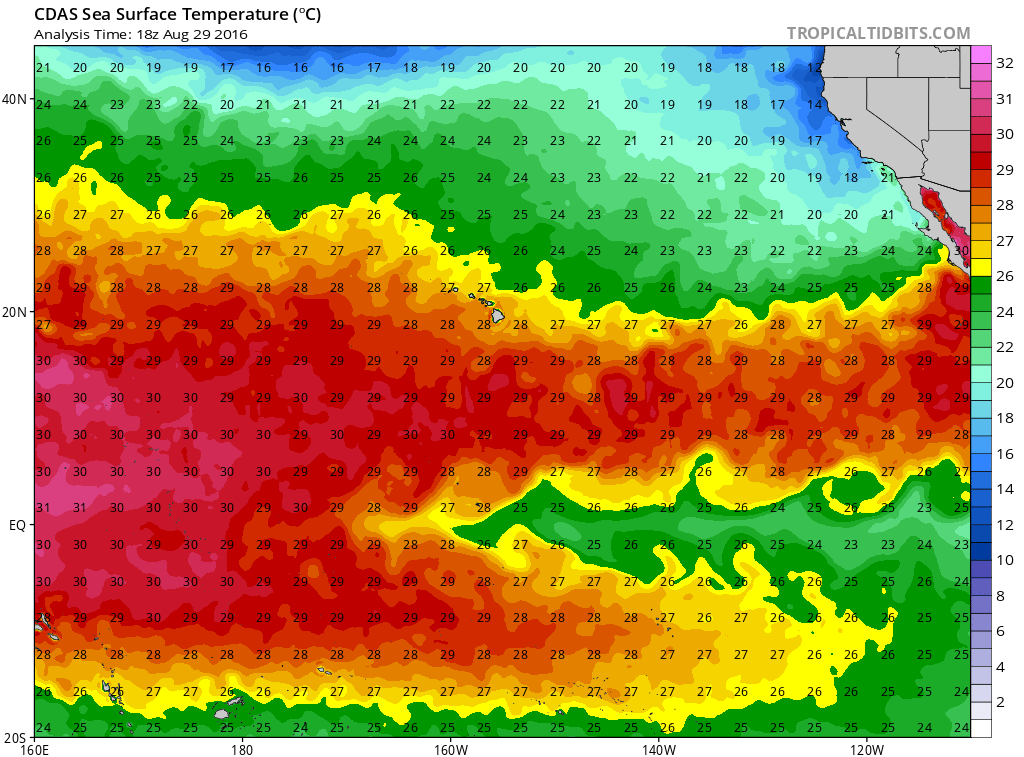
that time, marginally warm sea surface temperatures and a stable air
mass suggest that Lester will likely weaken gradually during the
next several days.
  The NHC intensity forecast is similar to the
previous one and is fairly close to the intensity model consensus.

Lester continues to move due westward about 12 kt on the south
side of a strong mid-level high pressure system.  A continued
westward track at about the same forward speed is predicted during
the next few days while the system remains to the south of the
ridge. After that time, a slight turn toward the west-northwest is
likely due to some interaction with another tropical cyclone,
Madeline, to its west-southwest.  The models remain tightly
clustered, and the NHC official track forecast lies near the middle
of the guidance envelope.  This forecast takes Lester close to the
Hawaiian Islands in about 5 days.

FORECAST POSITIONS AND MAX WINDS

INIT  30/0300Z 18.1N 131.8W  120 KT 140 MPH
12H  30/1200Z 18.2N 133.7W  115 KT 130 MPH
24H  31/0000Z 18.2N 136.0W  105 KT 120 MPH
36H  31/1200Z 18.3N 138.3W   95 KT 110 MPH
48H  01/0000Z 18.3N 140.5W   90 KT 105 MPH
72H  02/0000Z 19.0N 145.0W   85 KT 100 MPH
96H  03/0000Z 20.3N 149.9W   80 KT  90 MPH
120H  04/0000Z 22.0N 154.8W   70 KT  80 MPH

$$
Forecaster Cangialosi
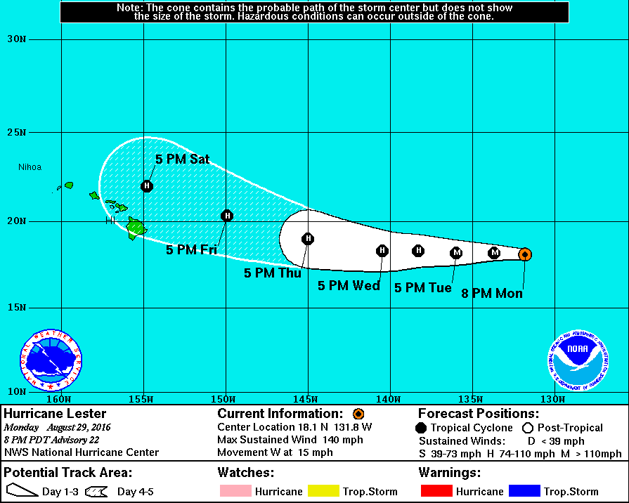
023731W5_NL_sm.gif

cdas-sflux_sst_cpac_1.png

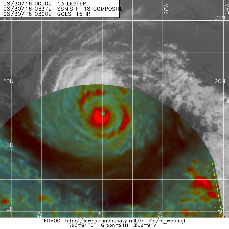
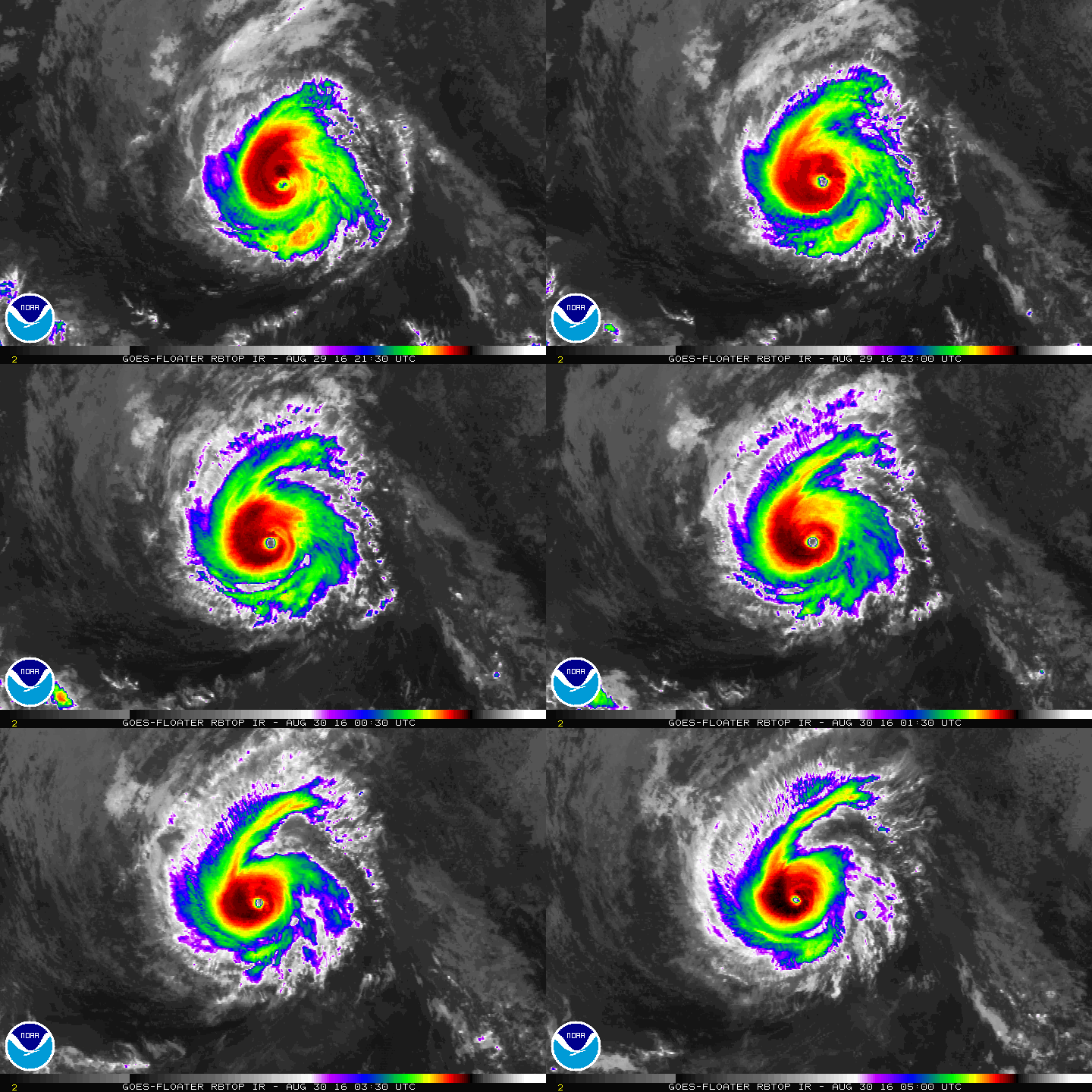
然而最新的底層可以看出北側已經薄弱不少,風眼也逐漸模糊,巔峰已經過去。
20160830.0337.f18.91pct91h91v.13E.LESTER.120kts.947mb.18.1N.131.2W.055pc.jpg

rbtop-animated.gif
回復

使用道具 舉報

簽到天數: 582 天

[LV.9]以壇為家II

蜜露|2016-8-30 20:45 | 顯示全部樓層


Lester (雷斯特)  的巔峰上到了Cat.4  120kts

加上今天的瑪德琳,也上到Cat.4

成為了東太平洋風王很難定勝負的角逐.

布拉斯的對流W成環 , 但眼溫最高. 對流以不如巔峰 喬杰特風眼清晰.但眼溫平凡 . 雷斯特反而偏向兩者均衡. 對流LG稍. 可是風眼清空卻特別出色.
瑪德琳看起來就是最沒特色的那個.

bandicam 2016-08-30 19-26-56-485.jpg


(天鵝 & 閃電的翻板) , 還有人說像品客洋芋片的表情.


回復

使用道具 舉報

簽到天數: 474 天

[LV.9]以壇為家II

劉瑞益@FB|2016-8-31 08:10 | 顯示全部樓層
提示: 作者被禁止或刪除 內容自動屏蔽
回復

使用道具 舉報

簽到天數: 3279 天

[LV.Master]伴壇終老

t02436|2016-8-31 11:04 | 顯示全部樓層
03Z正報再度評價120節,重回C4,預計24小時後進入中太
000
WTPZ43 KNHC 310256
TCDEP3

HURRICANE LESTER DISCUSSION NUMBER  26
NWS NATIONAL HURRICANE CENTER MIAMI FL       EP132016
800 PM PDT TUE AUG 30 2016

Lester has shown a sudden reintensification this evening as a
symmetric eyewall with very cold cloud tops is encircling a 25 nm
diameter warm eye.  Subjective Dvorak classifications from SAB and
TAFB are at 6.5 and 6.0 current intensity numbers, respectively,
while the CIMSS Advanced Dvorak Technique is at 6.3.  A blend of
these gives 120 kt maximum winds at the initial time, up
considerably from the previous advisory.

Lester is anticipated to experience quite low vertical shear for
the next few days, though the lukewarm SSTs and 40-50 percent
humidity air are only marginally conducive for maintaining high
intensities.  The current convective structure and its environment
suggest that Lester may be evolving into an annular hurricane,
which tends to weaken only slowly over time.  The NHC intensity
forecast is closest to the HWRF and DSHP models, and is above that
from the previous advisory due to the higher initial intensity.

Lester is moving toward the west-southwest at about 11 kt.  A large
subtropical ridge to its north is providing the westward steering
and low shear environment.  The tightly packed model guidance
indicate that the system should turn slightly toward the west or
west-northwest during the next two days at about the same rate of
forward speed.  The NHC track forecast is based upon the TVCN
multi-model consensus technique and is very close to that from the
previous advisory.

No new information is available about Lester's initial wind radii,
so that is unchanged from the previous advisory.  The NHC wind radii
forecast is based upon the RVCN consensus technique and nearly
the same as that from the last advisory.

FORECAST POSITIONS AND MAX WINDS

INIT  31/0300Z 17.8N 136.5W  120 KT 140 MPH
12H  31/1200Z 17.8N 138.1W  115 KT 130 MPH
24H  01/0000Z 17.9N 140.3W  110 KT 125 MPH
36H  01/1200Z 18.2N 142.5W  105 KT 120 MPH
48H  02/0000Z 18.7N 144.7W  100 KT 115 MPH
72H  03/0000Z 20.0N 149.6W   85 KT 100 MPH
96H  04/0000Z 21.8N 155.0W   75 KT  85 MPH
120H  05/0000Z 23.5N 159.5W   65 KT  75 MPH

$$
Forecaster Landsea

025600W_sm.gif

20160831.0034.f16.91pct91h91v.13E.LESTER.105kts.961mb.17.9N.135W.080pc.jpg

rb-animated.gif
回復

使用道具 舉報

簽到天數: 582 天

[LV.9]以壇為家II

蜜露|2016-8-31 22:57 | 顯示全部樓層


Lester的巔峰達到Cat.4  120kts  , 這是二次巔峰.

這個在西太平洋大概就一個中颱上限~強颱下限左右強度.

2016EP13_4KMSRBDC_201608310445.jpg


二次巔峰有完整的W環.  

我覺得雷斯特是東太平洋今年目前最完整的.

布拉斯風眼清空,對流已經剩LG
喬杰特的話是風眼清晰. 但對流不行
瑪德琳就是整體比較略差的.

後期應該會從夏威夷北部海面上去. 進入西太平洋機會很低

回復

使用道具 舉報

簽到天數: 474 天

[LV.9]以壇為家II

劉瑞益@FB|2016-9-1 09:51 | 顯示全部樓層
提示: 作者被禁止或刪除 內容自動屏蔽
回復

使用道具 舉報

簽到天數: 474 天

[LV.9]以壇為家II

劉瑞益@FB|2016-9-2 10:20 | 顯示全部樓層
提示: 作者被禁止或刪除 內容自動屏蔽
回復

使用道具 舉報

簽到天數: 474 天

[LV.9]以壇為家II

劉瑞益@FB|2016-9-8 03:58 | 顯示全部樓層
提示: 作者被禁止或刪除 內容自動屏蔽
回復

使用道具 舉報

12
快速回覆
您需要登錄後才可以回帖 登錄 | 立即加入

本版積分規則

本平台僅供學術討論之用,預報應以氣象局為準

威普網站虛擬主機贊助公司

臺灣第一個天氣類型社群平台 即時天氣資訊、精準颱風動態

線上客服
FB傳送訊息
廣告行銷
精準行銷 物超所值
官方粉專
發佈 快速回復 返回頂部 返回列表