開啟輔助訪問
 找回密碼
 立即加入

16P.Nora 卡灣發展 巔峰短暫 登陸約克角半島

簽到天數: 601 天

[LV.9]以壇為家II

霧峰追風者|2018-3-23 10:08 | 顯示全部樓層
有再捲眼的跡象,BoM 00Z強度升二級熱帶氣旋。
IDD20020
TROPICAL CYCLONE TECHNICAL BULLETIN: AUSTRALIA - NORTHERN REGION
Issued by DARWIN TROPICAL CYCLONE WARNING CENTRE
at: 0150 UTC 23/03/2018
Name: Tropical Cyclone Nora
Identifier: 22U
Data At: 0000 UTC
Latitude: 9.9S
Longitude: 137.0E
Location Accuracy: within 30 nm [55 km]
Movement Towards: east [090 deg]
Speed of Movement: 3 knots [5 km/h]
Maximum 10-Minute Wind: 50 knots [95 km/h]
Maximum 3-Second Wind Gust: 70 knots [130 km/h]
Central Pressure: 986 hPa
Radius of 34-knot winds NE quadrant: 90 nm [165 km]
Radius of 34-knot winds SE quadrant: 60 nm [110 km]
Radius of 34-knot winds SW quadrant: 70 nm [130 km]
Radius of 34-knot winds NW quadrant: 90 nm [165 km]
Radius of 48-knot winds NE quadrant: 20 nm [35 km]
Radius of 48-knot winds SE quadrant: 20 nm [35 km]
Radius of 48-knot winds SW quadrant: 20 nm [35 km]
Radius of 48-knot winds NW quadrant: 20 nm [35 km]
Radius of 64-knot winds:   
Radius of Maximum Winds: 20 nm [35 km]
Dvorak Intensity Code: T3.5/3.5/D1.5/24HRS STT:D0.5 6HRS
Pressure of outermost isobar: 1002 hPa
Radius of outermost closed isobar: 180 nm [335 km]
FORECAST DATA
Date/Time    : Location    : Loc. Accuracy: Max Wind   : Central Pressure
[UTC]        : degrees     :      nm  [km]: knots[km/h]: hPa
+06:  23/0600: 10.4S 137.7E:     030 [055]:  055  [100]:  984
+12:  23/1200: 10.9S 138.4E:     035 [065]:  060  [105]:  980
+18:  23/1800: 11.5S 139.1E:     040 [075]:  060  [115]:  977
+24:  24/0000: 12.2S 139.7E:     050 [090]:  070  [125]:  973
+36:  24/1200: 13.6S 140.4E:     070 [130]:  080  [145]:  964
+48:  25/0000: 14.7S 140.7E:     090 [165]:  085  [155]:  957
+60:  25/1200: 15.4S 140.8E:     110 [200]:  085  [155]:  958
+72:  26/0000: 15.8S 140.9E:     125 [235]:  080  [150]:  960
+96:  27/0000: 16.1S 140.7E:     170 [315]:  075  [135]:  966
+120: 28/0000: 16.9S 138.1E:     260 [480]:  060  [105]:  982
IDD65001 (1).png 20180323.0120.himawari-8.vis.16P.NORA.55kts.982mb.9.9S.136.9E.100pc.jpg rgb-animated (3).gif avn-animated (2).gif

回復

使用道具 舉報

簽到天數: 601 天

[LV.9]以壇為家II

霧峰追風者|2018-3-23 16:53 | 顯示全部樓層
JTWC 06Z強度升一級颶風。
sh162018.20180323082747.gif 20180323.0810.himawari-8.ir.16P.NORA.65kts.980mb.10.6S.138.1E.100pc.jpg 20180323.0810.himawari-8.ircolor.16P.NORA.65kts.980mb.10.6S.138.1E.100pc.jpg

回復

使用道具 舉報

簽到天數: 601 天

[LV.9]以壇為家II

霧峰追風者|2018-3-23 19:39 | 顯示全部樓層
本帖最後由 霧峰追風者 於 2018-3-24 09:12 編輯

BoM 強度升三級強烈熱帶氣旋,對流猛爆,快速增強。
IDD20020
TROPICAL CYCLONE TECHNICAL BULLETIN: AUSTRALIA - NORTHERN REGION
Issued by DARWIN TROPICAL CYCLONE WARNING CENTRE
at: 0753 UTC 23/03/2018
Name: Tropical Cyclone Nora
Identifier: 22U
Data At: 0600 UTC
Latitude: 10.4S
Longitude: 138.0E
Location Accuracy: within 20 nm [35 km]
Movement Towards: east southeast [117 deg]
Speed of Movement: 11 knots [20 km/h]
Maximum 10-Minute Wind: 60 knots [110 km/h]
Maximum 3-Second Wind Gust: 85 knots [155 km/h]
Central Pressure: 980 hPa
Radius of 34-knot winds NE quadrant: 90 nm [165 km]
Radius of 34-knot winds SE quadrant: 60 nm [110 km]
Radius of 34-knot winds SW quadrant: 70 nm [130 km]
Radius of 34-knot winds NW quadrant: 90 nm [165 km]
Radius of 48-knot winds NE quadrant: 30 nm [55 km]
Radius of 48-knot winds SE quadrant: 30 nm [55 km]
Radius of 48-knot winds SW quadrant: 30 nm [55 km]
Radius of 48-knot winds NW quadrant: 30 nm [55 km]
Radius of 64-knot winds:   
Radius of Maximum Winds: 30 nm [55 km]
Dvorak Intensity Code: T4.0/4.0/D1.5/24HRS STT:D1.0/6HRS
Pressure of outermost isobar: 1000 hPa
Radius of outermost closed isobar: 180 nm [335 km]
FORECAST DATA
Date/Time    : Location    : Loc. Accuracy: Max Wind   : Central Pressure
[UTC]        : degrees     :      nm  [km]: knots[km/h]: hPa
+06:  23/1200: 10.9S 138.7E:     030 [055]:  070  [130]:  981
+12:  23/1800: 11.5S 139.3E:     035 [065]:  080  [150]:  977
+18:  24/0000: 12.2S 139.9E:     040 [075]:  090  [165]:  973
+24:  24/0600: 12.9S 140.4E:     050 [090]:  095  [175]:  969
+36:  24/1800: 14.2S 140.9E:     070 [130]:  105  [195]:  960
+48:  25/0600: 15.1S 141.0E:     090 [165]:  105  [195]:  957
+60:  25/1800: 15.6S 141.2E:     110 [200]:  100  [185]:  959
+72:  26/0600: 15.8S 141.2E:     125 [235]:  100  [185]:  960
+96:  27/0600: 16.1S 140.7E:     170 [315]:  090  [165]:  968
+120: 28/0600: 17.2S 137.2E:     260 [480]:  060  [110]:  990
REMARKS:
Satellite imagery depicts a well-structured, organised system with deep
convection encircling the system and wraping around the LLCC.

Confidence in the location of the LLCC is good, based on a combination of VIS
satellite imagery and RADAR imagery, with the system centre now visible on the
edge of the Gove radar. Microwave imagery is consistent with satellite and radar
imagery. After recent slow movement to the east, radar imagery in the last hour
indicates the system has increased its forward speed on a south southeast track.

Dvorak analysis at 0600Z yielded a CI of 4.0, based on a 3h averaged DT of 4.0
using a 1.2 wrap. MET was set at 3.5 while PAT equaled 4.0 At 0600UTC, CIMSS ADT
was 3.9 while NESDIS ADT was 4.1. SATCON estimate of 53 knots at 22_2216UTC.
Intensity is set at 60 knots [10 min-mean].  

CIMSS at 0600UTC indicated the vertical wind shear is northeasterly at around 10
knots,  with Nora lying beneath an upper ridge. CIMMS analysis also depicts
poleward and equatorward outflow channels, suggesting significant further
development is likely in the short/medium term.

The system is expected to reach peak intensity as a Category 4 [105 kn] tropical
cyclone Saturday morning. Maximum intensity of Cat 4 is likley to be maintained
during much of Sunday, before increasing vertical wind shear restrict further
development. There is unlikley to be any significant weakening ,however, until
land interaction and further increases in wind shear during Monday or Tuesday.

The system is currently being steered to the east southeast by a westerly wind
surge, which will take it into the Gulf of Carpentaria during today. A weakening
mid-level ridge over southern Queensland allows the system to adopt a southwards
track into the southern Gulf of Carpentaria during Saturday and Sunday. Most NWP
tracks follow this scenario although UK and ACCESS-G take a more easterly track
over Cape York Peninsula. The influence of a mid-level ridge over Western
Australia is expected to slow the movement of the system from Sunday over the
southeast Gulf of Carpentaria and from Monday, west-southwest is expected to
take the system over inland Australia.

Copyright Commonwealth of Australia
==
The next bulletin for this system will be issued by: 23/1400 UTC by Darwin TCWC.
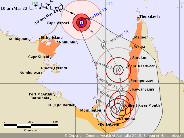
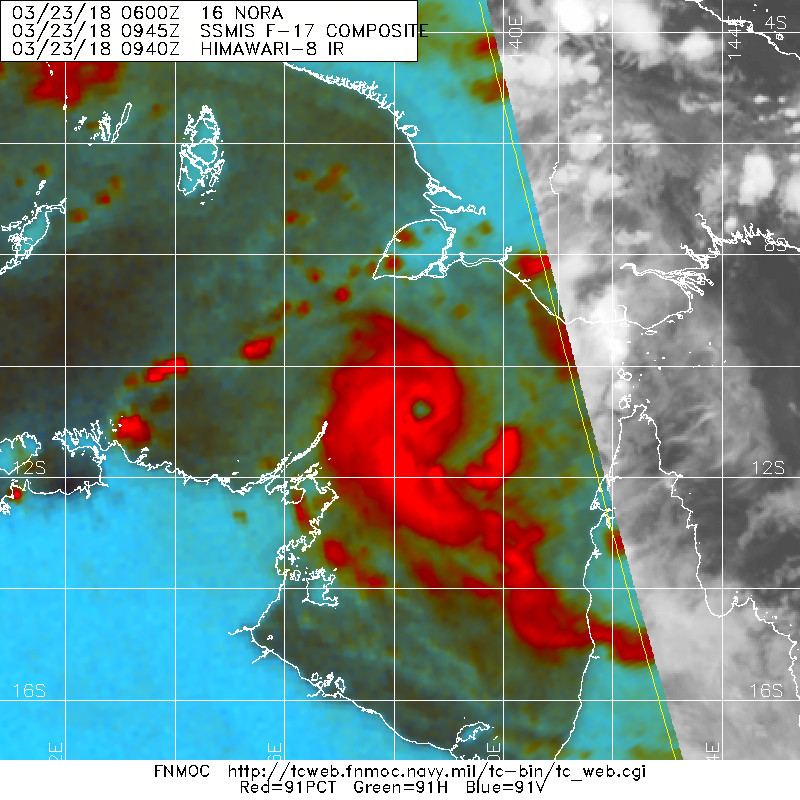
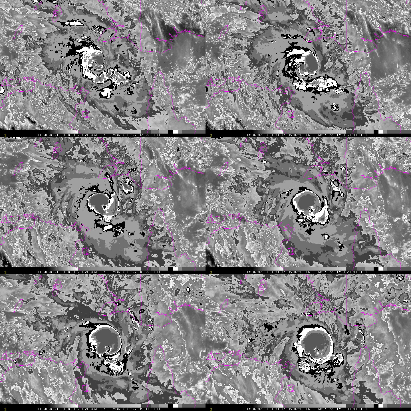
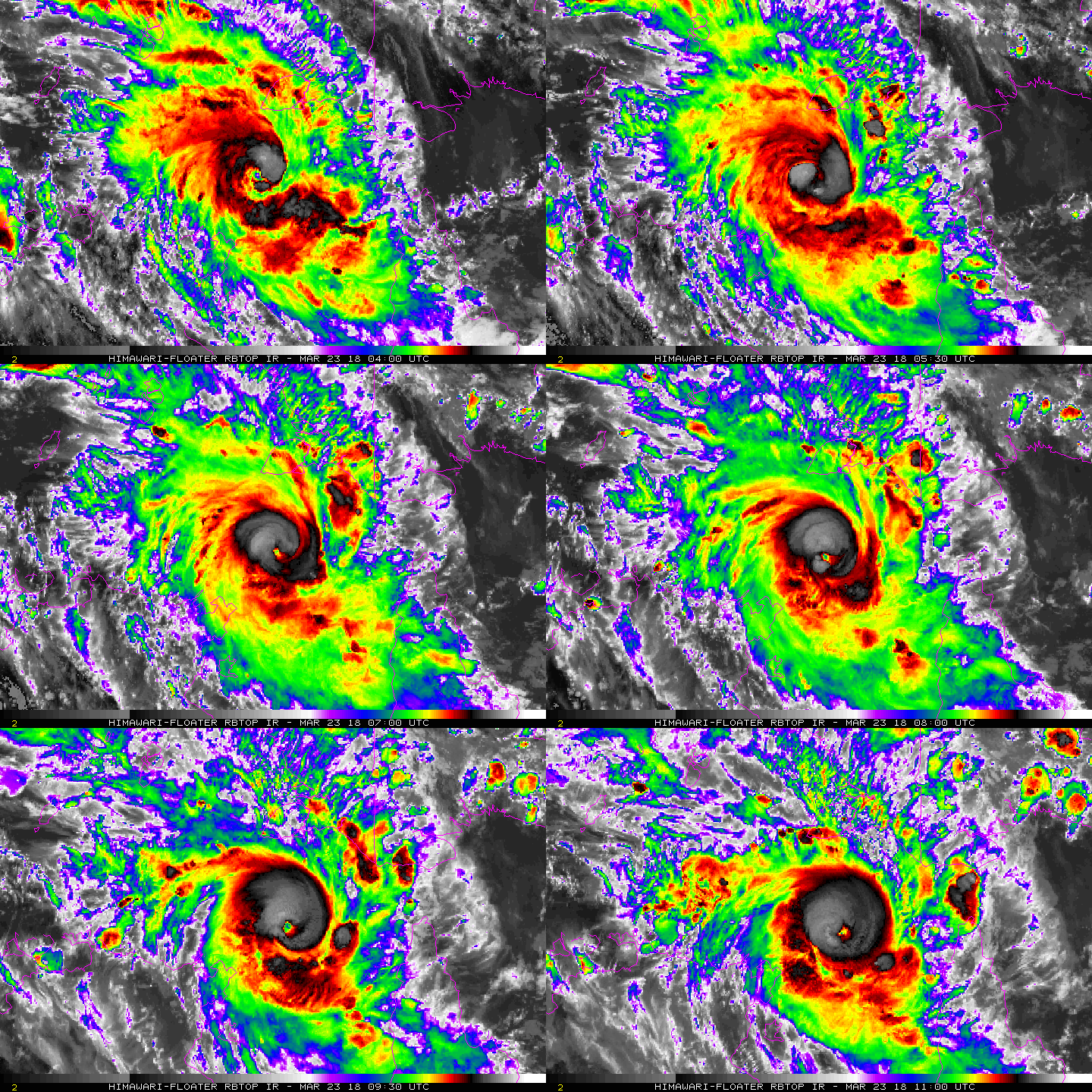
IDD65001.png 79_26427_86602b03a1125ed.jpg bd-animated.gif rbtop-animated.gif

回復

使用道具 舉報

簽到天數: 601 天

[LV.9]以壇為家II

霧峰追風者|2018-3-24 09:24 | 顯示全部樓層
本帖最後由 霧峰追風者 於 2018-3-24 09:50 編輯

受到風切影響,NORA增強已經受到壓制,BoM 認為仍有機會上望澳式C4。
IDD20020
TROPICAL CYCLONE TECHNICAL BULLETIN: AUSTRALIA - NORTHERN REGION
Issued by DARWIN TROPICAL CYCLONE WARNING CENTRE
at: 1944 UTC 23/03/2018
Name: Severe Tropical Cyclone Nora
Identifier: 22U
Data At: 1800 UTC
Latitude: 12.1S
Longitude: 139.4E
Location Accuracy: within 10 nm [20 km]
Movement Towards: southeast [141 deg]
Speed of Movement: 11 knots [20 km/h]
Maximum 10-Minute Wind: 85 knots [155 km/h]
Maximum 3-Second Wind Gust: 120 knots [220 km/h]
Central Pressure: 959 hPa
Radius of 34-knot winds NE quadrant: 90 nm [165 km]
Radius of 34-knot winds SE quadrant: 110 nm [205 km]
Radius of 34-knot winds SW quadrant: 90 nm [165 km]
Radius of 34-knot winds NW quadrant: 90 nm [165 km]
Radius of 48-knot winds NE quadrant: 45 nm [85 km]
Radius of 48-knot winds SE quadrant: 45 nm [85 km]
Radius of 48-knot winds SW quadrant: 45 nm [85 km]
Radius of 48-knot winds NW quadrant: 45 nm [85 km]
Radius of 64-knot winds: 25 nm [45 km]
Radius of Maximum Winds: 20 nm [35 km]
Dvorak Intensity Code: T5.0/5.0/D2.0/24HRS STT:S0.0/06HRS
Pressure of outermost isobar: 1002 hPa
Radius of outermost closed isobar: 180 nm [335 km]
FORECAST DATA
Date/Time    : Location    : Loc. Accuracy: Max Wind   : Central Pressure
[UTC]        : degrees     :      nm  [km]: knots[km/h]: hPa
+06:  24/0000: 12.9S 140.0E:     020 [040]:  090  [165]:  957
+12:  24/0600: 13.7S 140.5E:     035 [065]:  090  [165]:  952
+18:  24/1200: 14.5S 140.8E:     045 [085]:  095  [175]:  946
+24:  24/1800: 15.2S 140.9E:     060 [110]:  100  [185]:  942
+36:  25/0600: 16.2S 141.0E:     080 [145]:  105  [195]:  936
+48:  25/1800: 16.6S 141.0E:     100 [180]:  105  [195]:  934
+60:  26/0600: 16.9S 140.8E:     120 [220]:  105  [195]:  935
+72:  26/1800: 17.1S 140.6E:     135 [255]:  100  [185]:  940
+96:  27/1800: 17.5S 138.4E:     180 [335]:  070  [130]:  970
+120: 28/1800: 18.6S 132.2E:     270 [500]:  030  [055]: 1001
JTWC 00Z強度稍微下修至90kts。 20180324.0050.himawari-8.ircolor.16P.NORA.90kts.956mb.12.6S.140.1E.100pc.jpg
IDQP0011.png wgmssht.gif rbtop-animated (3).gif

回復

使用道具 舉報

簽到天數: 582 天

[LV.9]以壇為家II

蜜露|2018-3-24 15:53 | 顯示全部樓層
本帖最後由 蜜露 於 2018-3-24 15:55 編輯


現在風切減弱了許多 , 底層重新完成 .
但是可能發展時間有所限制 , 強度上比之前有所降低.

bandicam 2018-03-24 15-45-16-204.jpg


wgmssht.GIF

2018SH16_OHCNFCST_201803240000.GIF
說真的如果不是風切干擾 , 這氣旋的強度天賦可能比馬庫斯強
可說是前途無量 .  


回復

使用道具 舉報

簽到天數: 3279 天

[LV.Master]伴壇終老

t02436|2018-3-24 23:52 | 顯示全部樓層
中心已經登陸。
TROPICAL CYCLONE ADVICE NUMBER 24
Issued at 1:27 am AEST [12:57 am ACST] on Sunday 25 March 2018

Headline:
Severe Tropical Cyclone Nora is currently crossing the western coast of Cape York Peninsula north of Pormpuraaw.

Areas Affected:
Warning Zone
Karumba to Aurukun.

Watch Zone
NT/Qld Border to Karumba, including Mornington Island.

Cancelled Zone
Aurukun to Weipa.

Details of Severe Tropical Cyclone Nora at 10:00 pm AEST [9:30 pm ACST]:
Intensity: Category 3, sustained winds near the centre of 120 kilometres per hour with wind gusts to 165 kilometres per hour.

Location: within 20 kilometres of 14.4 degrees South 141.5 degrees East, estimated to be 55 kilometres north northwest of Pormpuraaw and 125 kilometres north northwest of Kowanyama.

Movement: south southeast at 20 kilometres per hour.

Severe Tropical Cyclone Nora, Category 3, is tracking south southeastwards, slowly crossing the coast north of Pormpuraaw. As the system is moving somewhat parallel to the coast, the period of crossing will be extended, and the cyclone is only expected to weaken slowly and may still be a Category 2 or Category 3 system as it approaches Kowanyama on sunday morning.

From later Sunday, the Tropical Cyclone is expected to continue gradually weakening as it becomes slow moving over land near the southwestern base of Cape York Peninsula.

The system may move back over water in the southeastern Gulf of Carpentaria late Monday or on Tuesday, where it may reintensify briefly to a Category 1 cyclone.

IDQP0011.png

rbtop-animated.gif

回復

使用道具 舉報

簽到天數: 601 天

[LV.9]以壇為家II

霧峰追風者|2018-3-25 15:30 | 顯示全部樓層
降格熱帶低壓,不過有機會出海後再升格。
IDQ20018
TROPICAL CYCLONE TECHNICAL BULLETIN: AUSTRALIA - EASTERN REGION
Issued by BRISBANE TROPICAL CYCLONE WARNING CENTRE
at: 0644 UTC 25/03/2018
Name: Ex-Tropical Cyclone Nora
Identifier: 22U
Data At: 0600 UTC
Latitude: 16.6S
Longitude: 141.3E
Location Accuracy: within 30 nm [55 km]
Movement Towards: south [185 deg]
Speed of Movement: 5 knots [9 km/h]
Maximum 10-Minute Wind: 30 knots [55 km/h]
Maximum 3-Second Wind Gust: 50 knots [95 km/h]
Central Pressure: 989 hPa
Radius of 34-knot winds NE quadrant:   
Radius of 34-knot winds SE quadrant:   
Radius of 34-knot winds SW quadrant:   
Radius of 34-knot winds NW quadrant:   
Radius of 48-knot winds NE quadrant:   
Radius of 48-knot winds SE quadrant:   
Radius of 48-knot winds SW quadrant:   
Radius of 48-knot winds NW quadrant:   
Radius of 64-knot winds:   
Radius of Maximum Winds:   
Dvorak Intensity Code: None possible.
Pressure of outermost isobar: 1002 hPa
Radius of outermost closed isobar: 150 nm [280 km]
FORECAST DATA
Date/Time    : Location    : Loc. Accuracy: Max Wind   : Central Pressure
[UTC]        : degrees     :      nm  [km]: knots[km/h]: hPa
+06:  25/1200: 16.9S 141.3E:     030 [060]:  030  [055]:  991
+12:  25/1800: 16.9S 141.2E:     045 [080]:  030  [055]:  994
+18:  26/0000: 16.9S 141.1E:     055 [105]:  030  [055]:  996
+24:  26/0600: 16.8S 141.1E:     070 [130]:  030  [055]:  996
+36:  26/1800: 16.4S 140.8E:     090 [165]:  030  [055]:  995
+48:  27/0600: 16.2S 140.0E:     110 [200]:  035  [065]:  990
+60:  27/1800: 16.1S 138.1E:     130 [235]:  040  [075]:  988
+72:  28/0600: 16.3S 135.3E:     145 [270]:  025  [045]:  999
+96:  29/0600:             :              :            :     
+120: 30/0600:             :              :            :     
IDQ65001 (1).png 20180325.0640.himawari-8.vis.16P.NORA.30kts.996mb.17.6S.142.3E.100pc.jpg

回復

使用道具 舉報

12
快速回覆
您需要登錄後才可以回帖 登錄 | 立即加入

本版積分規則

本平台僅供學術討論之用,預報應以氣象局為準

威普網站虛擬主機贊助公司

臺灣第一個天氣類型社群平台 即時天氣資訊、精準颱風動態

線上客服
FB傳送訊息
廣告行銷
精準行銷 物超所值
官方粉專
發佈 快速回復 返回頂部 返回列表