開啟輔助訪問
 找回密碼
 立即加入

06L.Florence 自西非長遠西行 二度上MH 後襲擊美國東岸

簽到天數: 601 天

[LV.9]以壇為家II

霧峰追風者|2018-9-6 03:24 | 顯示全部樓層
18z 風眼清空,強度升四級颶風。
20180905.1830.msg-4.ir.06L.FLORENCE.115kts.953mb.22.4N.46.2W.100pc.jpg 20180905.1828.f16.vis.olsviscomp.06L.FLORENCE.x.jpg 20180905.1828.f16.ir.olsircomp.06L.FLORENCE.x.jpg

回復

使用道具 舉報

簽到天數: 3279 天

[LV.Master]伴壇終老

t02436|2018-9-6 14:24 | 顯示全部樓層
補一下21Z的C4評價,雖然03Z已經略為減弱到110節,但5天後仍看好重回115節強度。
ZCZC MIATCDAT1 ALL
TTAA00 KNHC DDHHMM

Hurricane Florence Discussion Number  26
NWS National Hurricane Center Miami FL       AL062018
500 PM AST Wed Sep 05 2018

Florence has continued to intensify during the day, with colder
cloud tops completely encircling a clearer eye. Both subjective and
objective Dvorak estimates have unanimously increased to T6.0/115
kt, and on this basis, the initial intensity is raised to 115 kt,
making Florence a category 4 hurricane.

Florence appears to be right along the southern edge of a zone of
stronger vertical shear and continues to defy the intensity
guidance, which has consistently been predicting weakening.  That
said, the last few satellite images indicate that the eye may be
becoming slightly disrupted by the shear.  Since the shear is
anticipated to increase during the next day or so, gradual weakening
is shown in the short-term official forecast, which lies along the
upper end of the guidance through 48 hours.  Beyond 48 hours,
vertical shear is anticipated to weaken, which would allow Florence
to intensify and potentially regain major hurricane status. However,
Florence will need to thread the needle between areas of stronger
shear for this to happen, and there is significant uncertainty in
the intensity forecast.  The new official intensity forecast is
little changed from before except to adjust upward to account for
the higher initial intensity.

The initial motion estimate remains northwestward, or 305/11 kt.
Strong upper-level ridging is forecast to strengthen north of
Florence over the next few days, forcing the hurricane to turn
toward the west-northwest through about 48 hours.  Track guidance is
good agreement during this period, and the official forecast is
essentially an update to the previous one.  Beyond day 2, a break
forms in the ridge, which results in a weakening of the steering
currents, a slowdown in Florence's forward speed, and a turn back
toward the northwest. The new official forecast is shifted south a
bit on days 3-5 to account for recent model trends and is closest to
the TVCN consensus.

It should be noted that there is considerable model ensemble spread
and run-to-run variability for Florence's track beyond day 5. Given
the large uncertainty at these time ranges, it is far too soon to
speculate what, if any, impacts Florence may have on the U.S. East
Coast next week. Regardless of Florence's eventual track, large
swells emanating from the hurricane will reach Bermuda beginning on
Friday, resulting in life-threatening surf and rip currents on the
island. Swells from Florence could also reach the U.S. East Coast by
early next week.

FORECAST POSITIONS AND MAX WINDS

INIT  05/2100Z 22.7N  46.6W  115 KT 130 MPH
12H  06/0600Z 23.5N  48.1W  110 KT 125 MPH
24H  06/1800Z 24.5N  49.7W  105 KT 120 MPH
36H  07/0600Z 25.2N  51.3W  100 KT 115 MPH
48H  07/1800Z 25.5N  52.9W   95 KT 110 MPH
72H  08/1800Z 26.0N  55.3W  100 KT 115 MPH
96H  09/1800Z 27.0N  57.4W  105 KT 120 MPH
120H  10/1800Z 29.0N  60.0W  105 KT 120 MPH

$$
Forecaster Berg/Rhome

NNNN

下載.png

INIT  06/0300Z 23.4N  47.2W  110 KT 125 MPH
12H  06/1200Z 24.2N  48.4W  105 KT 120 MPH
24H  07/0000Z 25.0N  49.9W  100 KT 115 MPH
36H  07/1200Z 25.5N  51.6W   95 KT 110 MPH
48H  08/0000Z 25.7N  53.2W   95 KT 110 MPH
72H  09/0000Z 26.1N  55.7W  100 KT 115 MPH
96H  10/0000Z 27.2N  58.1W  105 KT 120 MPH
120H  11/0000Z 29.0N  62.0W  115 KT 130 MPH

GOES06002018249weiyBb.jpg
回復

使用道具 舉報

簽到天數: 3279 天

[LV.Master]伴壇終老

t02436|2018-9-9 19:07 | 顯示全部樓層
即將開始加速移動,強度也將重回C1。
飛機實測將在稍後啟動,未來將挑戰原先115節巔峰強度,目前預測五天後以C4強度登陸。
701
WTNT41 KNHC 090844
TCDAT1

Tropical Storm Florence Discussion Number  40
NWS National Hurricane Center Miami FL       AL062018
500 AM AST Sun Sep 09 2018

Florence's cloud pattern has continued to gradually become better
organized overnight, with an increase in convection near the center
and a developing central dense overcast feature.  However, the
cloud tops are not particularly cold and the outer banding features
remain fragmented likely due to some nearby dry mid-level air.
Dvorak intensity estimates from TAFB and SAB range from 55 to 65
kt, so the initial intensity remains 60 kt, just shy of hurricane
strength.  The NOAA Hurricane Hunters are scheduled to investigate
the storm later today
, and that data should provide a better
assessment of Florence's intensity.

The upper-level outflow is becoming well established over the
cyclone, and the global model guidance indicates that Florence
will remain in a very favorable upper-level environment while the
cyclone moves over the warm waters over the southwestern
Atlantic.  These conditions favor strengthening with the only
apparent negative factor being nearby dry air, which will likely
remain away from the inner core due to the low shear conditions.
The NHC intensity forecast again calls for a period of rapid
strengthening within the next 12-36 hours, and Florence is forecast
to become a major hurricane on Monday with additional strengthening
early in the week.  This means that Florence is likely to be a very
powerful hurricane as it moves over the western Atlantic toward the
southeastern United States.  The new NHC intensity forecast is near
the various intensity consensus aids and is very similar to the
previous official forecast.

Florence is currently located between a couple of mid-level ridges
and a slow westward motion is expected today.  Another strong
high pressure ridge is forecast to build to the north of Florence
on Monday, which should cause the storm to begin moving
west-northwestward to northwestward at an increasingly faster
forward speed.  The dynamical model guidance is tightly clustered
for the first 2-3 days with increasing spread thereafter.  The GFS
remains along the right side of the guidance envelope with the HWRF
and ECMWF bracketing the left edge.  It should be noted that both
the GFS and ECMWF ensemble means are a little to the left or west
of their operational runs.  As a result, the NHC track forecast
lies to the left of the TVCA multi-model consensus, but is not as
far to the west as the FSSE and HCCA corrected consensus models at
day 5.  The models are in agreement that Florence is likely to slow
down near the end of the forecast period as a blocking high
pressure ridge builds to the north of the hurricane.

Key Messages:

1. Florence is forecast to be a dangerous major hurricane near the
southeast U.S. coast by late this week, and the risk of direct
impacts continues to increase. However, given the uncertainty in
track and intensity forecasts at those time ranges, it's too soon to
determine the exact timing, location, and magnitude of those
impacts.

2. Interests along the U.S. East Coast, particularly from north
Florida through North Carolina, should closely monitor the progress
of Florence, ensure they have their hurricane plan in place, and
follow any advice given by local officials.

3. Large swells affecting Bermuda and portions of the U.S. East
Coast will continue this week.  These swells will result in
life-threatening surf and rip currents.

FORECAST POSITIONS AND MAX WINDS

INIT  09/0900Z 24.5N  55.8W   60 KT  70 MPH
12H  09/1800Z 24.6N  56.7W   70 KT  80 MPH
24H  10/0600Z 24.8N  58.3W   85 KT 100 MPH
36H  10/1800Z 25.3N  60.4W  100 KT 115 MPH
48H  11/0600Z 26.1N  63.1W  110 KT 125 MPH
72H  12/0600Z 28.2N  69.1W  125 KT 145 MPH
96H  13/0600Z 31.3N  74.8W  120 KT 140 MPH
120H  14/0600Z 34.4N  77.9W  105 KT 120 MPH...INLAND

$$
Forecaster Brown

084537_5day_cone_with_line.png

06L_intensity_latest.png

20180909.0713.f15.85rgb.06L.FLORENCE.60kts.989mb.24.5N.55.5W.050pc.jpg

goes16_ir_06L_201809091035.jpg

goes16_truecolor_06L_201809091050.jpg
回復

使用道具 舉報

簽到天數: 601 天

[LV.9]以壇為家II

霧峰追風者|2018-9-10 06:02 | 顯示全部樓層
強度重回一級颶風,巔峰上望130節,4天後直襲美東,另外美國已經要啟動飛機實測。
270
WTNT41 KNHC 092053
TCDAT1

Hurricane Florence Discussion Number  42
NWS National Hurricane Center Miami FL       AL062018
500 PM AST Sun Sep 09 2018

The last reconnaissance fix indicated that the pressure had fallen
to about 978 mb with Florence, a drop of about 6 mb in 4 hours, with
uncontaminated SFMR winds of about 70 kt. Since then, the satellite
presentation has continued to improve, with intensifying deep
convection near the center.  Thus the wind speed is set to 75 kt on
this advisory.

Radar data from the NOAA Hurricane Hunter indicated that there were
still a few breaks in the eyewall, possibly allowing some dry air to
mix into the core.  This structure has potentially kept Florence
from intensifying rapidly so far.  It is likely, however, that the
eyewall will close soon with low environmental shear present,
resulting in a faster intensification rate.  The guidance is
remarkably well clustered, with all of the hurricane models showing
category 4 strength within 48 hours, which is uncommon given the
current intensity.  The new forecast continues to show rapid
intensification and is increased 5 or 10 kt at most time periods,
but it is still not as high as the Florida State Superensemble or
the NOAA corrected consensus models.  It is worth noting that the
model guidance is also significantly increasing the size of
Florence's wind field over the next few days, and the official
forecast reflects this trend.

The fixes from the aircraft indicate that Florence hasn't gained
much latitude yet, and continues moving westward at about 6 kt.
There is no change to the synoptic reason as a very strong ridge is
forecast to build over the northwestern Atlantic during the next few
days.  This pattern should steer Florence west-northwestward at a
much faster forward speed by Tuesday.  On Wednesday, the hurricane
will likely turn northwestward and slow down somewhat due to another
ridge forming over the Ohio Valley.   The most notable change from
the previous advisory is that most of the models are showing a
faster motion in 3 or 4 days, which unfortunately increases the risk
of a destructive hurricane landfall.  The GFS and its ensemble mean
are outliers from the main model envelope, showing the system near
the Outer Banks, while the rest of the guidance is well to the
southwest. While a near-miss isn't impossible given the spread of
the ECMWF Ensemble, there is much more support for a track to the
southwest, especially considering the poleward bias of the GFS thus
far this season. Therefore, the official track forecast is shifted a
little bit to the southwest, and is very close to the
corrected-consensus models.

The NOAA G-IV jet is conducting a synoptic surveillance mission this
afternoon to gather data near and around Florence for assimilation
into the numerical models, and these missions will continue through
Tuesday. In addition, upper-air stations across portions of the
central and eastern U.S. are conducting special 0600 UTC and 1800
UTC radiosonde launches to collect extra data for the numerical
models. Hopefully these data will help improve the track and
intensity forecasts.


Key Messages:

1. There is an increasing risk of two life-threatening impacts from
Florence: storm surge at the coast and freshwater flooding from a
prolonged heavy rainfall event inland. While it is too soon to
determine the exact timing, location, and magnitude of these
impacts, interests at the coast and inland from South Carolina into
the mid-Atlantic region should closely monitor the progress of
Florence, ensure they have their hurricane plan in place, and follow
any advice given by local officials.

2. Large swells affecting Bermuda and portions of the U.S. East
Coast will continue this week.  These swells will result in
life-threatening surf and rip currents.


FORECAST POSITIONS AND MAX WINDS

INIT  09/2100Z 24.4N  57.0W   75 KT  85 MPH
12H  10/0600Z 24.6N  58.3W   90 KT 105 MPH
24H  10/1800Z 25.1N  60.4W  105 KT 120 MPH
36H  11/0600Z 25.9N  63.1W  115 KT 130 MPH
48H  11/1800Z 27.0N  66.2W  125 KT 145 MPH
72H  12/1800Z 30.3N  72.6W  130 KT 150 MPH
96H  13/1800Z 33.5N  77.5W  120 KT 140 MPH
120H  14/1800Z 35.0N  79.0W   60 KT  70 MPH...INLAND

$$
Forecaster Blake

205027_5day_cone_no_line_and_wind.png rgb-animated (3).gif rbtop-animated (4).gif
回復

使用道具 舉報

簽到天數: 3279 天

[LV.Master]伴壇終老

t02436|2018-9-10 23:35 | 顯示全部樓層
風眼開啟,15Z重新回到MH,將持續增強,36小時之後達到巔峰。
ZCZC MIATCDAT1 ALL
TTAA00 KNHC DDHHMM

Hurricane Florence Discussion Number  45
NWS National Hurricane Center Miami FL       AL062018
1100 AM AST Mon Sep 10 2018

Florence is quickly becoming a powerful hurricane.  Satellite images
show that the distinct eye has warmed in the center, with convection
increasing in the eyewall during the past several hours. The initial
wind speed is set to 100 kt, closest to the CIMSS-ADT value.  A NOAA
Hurricane Hunter will be in the area later this morning for a more
accurate estimate.


The hurricane is moving over progressively warmer waters over
the next couple of days, with water temperatures peaking near 85F.
In combination with the low vertical wind shear in the forecast
during that time, Florence should continue to strengthen, and all
models show it becoming a category 4 hurricane by tomorrow.  The
corrected-consensus guidance has done quite well with this
intensification episode, and I don't see any reason to deviate much
from them at this time.  As Florence approaches the southeastern
United States, there will likely be fluctuations in intensity from
eyewall cycles, but even if this occurs, the hurricane's wind field
is expected to grow with time, increasing the storm surge and inland
wind threats.  The bottom line is that there is increasing
confidence that Florence will be a large and extremely dangerous
hurricane, regardless of its exact intensity.

During the last several hours, Florence has turned westward again,
estimated at 11 kt.  The steering currents are becoming well-
defined as as a very strong ridge builds over the northwestern
Atlantic Ocean, forcing Florence to move faster toward the
west-northwest during the next couple of days.  By late Wednesday,
a turn toward the northwest is possible due to the orientation of
the Atlantic ridge, along with a slight decrease in forward speed
due to a new ridge building over the Great Lakes.  The various
models are shifting around at long range, but the model consensus
has barely budged in the past few model cycles.  Thus the new NHC
forecast is close to the previous one, near the NOAA and FSSE
consensus guidance.  It is important not to focus on the exact
forecast track as average NHC errors at days 4 and 5 are about 140
and 180 n mi, respectively, and dangerous hazards will extend well
away from the center.

Key Messages:

1. A life-threatening storm surge is likely along portions of the
coastlines of South Carolina, North Carolina, and Virginia, and
a Storm Surge Watch will likely be issued for some of these areas by
Tuesday morning. All interests from South Carolina into the
mid-Atlantic region should ensure they have their hurricane plan in
place and follow any advice given by local officials.

2. Life-threatening freshwater flooding is likely from a prolonged
and exceptionally heavy rainfall event, which may extend inland over
the Carolinas and Mid Atlantic for hundreds of miles as Florence is
expected to slow down as it approaches the coast and moves inland.

3. Damaging hurricane-force winds are likely along portions of the
coasts of South Carolina and North Carolina, and a Hurricane Watch
will likely be issued by Tuesday morning. Damaging winds could also
spread well inland into portions of the Carolinas and Virginia.

4. Large swells affecting Bermuda and portions of the U.S. East
Coast will continue this week, resulting in life-threatening surf
and rip currents.

FORECAST POSITIONS AND MAX WINDS

INIT  10/1500Z 25.0N  60.0W  100 KT 115 MPH
12H  11/0000Z 25.5N  61.9W  115 KT 130 MPH
24H  11/1200Z 26.4N  64.7W  125 KT 145 MPH
36H  12/0000Z 27.8N  67.9W  130 KT 150 MPH
48H  12/1200Z 29.5N  71.0W  130 KT 150 MPH
72H  13/1200Z 33.0N  76.3W  125 KT 145 MPH
96H  14/1200Z 35.0N  79.0W   75 KT  85 MPH...INLAND
120H  15/1200Z 36.0N  80.0W   30 KT  35 MPH...INLAND

$$
Forecaster Blake

NNNN

145000_5day_cone_with_line.png

LATEST.jpg

20180910.1116.f17.91pct91h91v.06L.FLORENCE.100kts.962mb.24.9N.59.5W.065pc.jpg

goes16_truecolor_06L_201809101505.jpg

goes16_ir_06L_201809101505.jpg
回復

使用道具 舉報

簽到天數: 582 天

[LV.9]以壇為家II

蜜露|2018-9-11 01:19 | 顯示全部樓層
本帖最後由 蜜露 於 2018-9-11 01:20 編輯


西北太平洋有27W和山竹接近亞洲,中國、台灣和菲律賓警戒。


北大西洋這裡弗羅洛絲和艾薩克也正在威脅美洲國家,弗羅洛絲正逼近美國東部。
wg8sht (1).GIF


弗羅洛絲的條件或許沒有山竹優秀。
但是這風切目前還沒有直接對弗羅洛絲造成正面傷害。


率先取得了Cat.4


未來限制了環境發展,最強應該就是維持Cat.4
緯度比較高,沒有經過高潛熱。

回復

使用道具 舉報

簽到天數: 3279 天

[LV.Master]伴壇終老

t02436|2018-9-11 09:21 | 顯示全部樓層
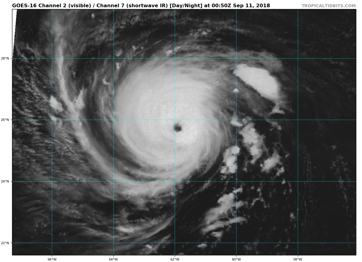
21Z評價120節,已經超越第一次巔峰的115節,上望135節。
366
WTNT41 KNHC 102055
TCDAT1

Hurricane Florence Discussion Number  46
NWS National Hurricane Center Miami FL       AL062018
500 PM AST Mon Sep 10 2018

Unfortunately, the models were right. Florence has rapidly
intensified into an extremely dangerous hurricane, with 30-second
GOES-16 visible imagery showing well-defined eyewall mesovortices
rotating inside of the eye. A NOAA Hurricane Hunter aircraft found
peak SFMR winds of about 120 kt, with flight-level winds and
dropsonde measurements also supporting that value for the initial
wind speed estimate. Notably, the aircraft data also show the size
of the hurricane-force winds has doubled in the past 12 hours.

None of the guidance suggest that Florence has peaked in intensity,
and this is supported by a continuation of a low-shear environment,
and even warmer waters over the next 36 hours.  Thus, the intensity
forecast is raised from the previous one, bringing Florence close
to category 5 strength tomorrow. Near landfall, the vertical wind
shear could increase, along with the increasing likelihood of
eyewall cycles.  While the intensity forecast shows some weakening
of the maximum winds near landfall, the wind field is expected to
grow with time, which increases the storm surge and inland wind
threats.  The bottom line is that there is high confidence that
Florence will be a large and extremely dangerous hurricane,
regardless of its exact intensity.

Florence has recently turned west-northwestward, still moving at 11
kt. The hurricane is expected to accelerate in that direction over
the next day or two due to building mid-level ridge over the
northwestern Atlantic Ocean.  By late Wednesday, a turn toward the
northwest is forecast due to the orientation of the Atlantic ridge,
along with a decrease in forward speed due to a new ridge building
over the Great Lakes.  There is a new player in the forecast as
well, with the disturbance over the northwestern Caribbean adding
some uncertainty in the ridge strength over the southeastern United
States.  Perhaps it isn't surprising that the model spread has
increased on this cycle, with a small eastward shift overall.  The
official forecast is nudged in the direction of the trend, but is
west of the model consensus.  It is important not to focus on the
exact forecast track as average NHC errors at days 4 and 5 are about
140 and 180 n mi, respectively, and dangerous hazards will extend
well away from the center.

The NOAA G-IV jet will continue to conduct synoptic surveillance
missions every 12 h through at least Wednesday. In addition, special
0600 UTC and 1800 UTC radiosonde launches have been expanded to
additional upper-air stations across the U.S. are to collect extra
data for the numerical models.

Key Messages:

1. A life-threatening storm surge is likely along portions of the
coastlines of South Carolina, North Carolina, and Virginia, and
a Storm Surge Watch will likely be issued for some of these areas by
Tuesday morning. All interests from South Carolina into the mid-
Atlantic region should ensure they have their hurricane plan in
place and follow any advice given by local officials.

2. Life-threatening freshwater flooding is likely from a prolonged
and exceptionally heavy rainfall event, which may extend inland over
the Carolinas and Mid Atlantic for hundreds of miles as Florence is
expected to slow down as it approaches the coast and moves inland.

3. Damaging hurricane-force winds are likely along portions of the
coasts of South Carolina and North Carolina, and a Hurricane Watch
will likely be issued by Tuesday morning. Damaging winds could also
spread well inland into portions of the Carolinas and Virginia.

4. Large swells affecting Bermuda and portions of the U.S. East
Coast will continue this week, resulting in life-threatening surf
and rip currents.

FORECAST POSITIONS AND MAX WINDS

INIT  10/2100Z 25.4N  61.1W  120 KT 140 MPH
12H  11/0600Z 26.0N  63.2W  130 KT 150 MPH
24H  11/1800Z 27.0N  66.2W  135 KT 155 MPH
36H  12/0600Z 28.6N  69.3W  135 KT 155 MPH
48H  12/1800Z 30.4N  72.2W  130 KT 150 MPH
72H  13/1800Z 33.7N  77.0W  120 KT 140 MPH
96H  14/1800Z 35.6N  78.8W   50 KT  60 MPH...INLAND
120H  15/1800Z 36.5N  79.5W   25 KT  30 MPH...INLAND

$$
Forecaster Blake
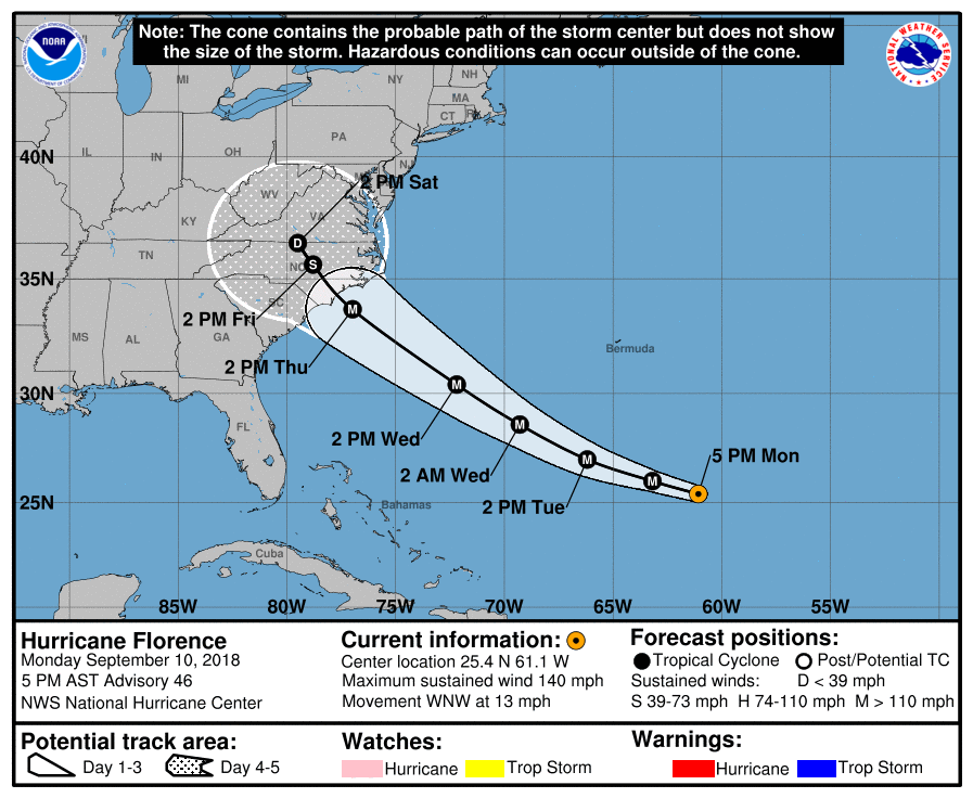
205721_5day_cone_with_line.png

goes16_vis-swir_06L_201809110050.jpg

點評

它應該還有增強空間持續猛爆增強上5級應該還是不無可能。  發表於 2018-9-12 14:24
不過它挺強悍的目前強度相當於我們這邊一個51~53m/s風速的強烈颱風。  發表於 2018-9-12 14:21
那邊的朋友這次嚇很大說,新聞說它是自安德魯颶風以來至今26年來美國東岸最強颶風??...好像還有過更強的吧?  發表於 2018-9-12 14:18
這傢伙就是最近幾日害美國東部爆發逃難潮撤離百萬居民頂頂大名的佛羅倫斯颶風吧。  發表於 2018-9-12 14:17
回復

使用道具 舉報

簽到天數: 3279 天

[LV.Master]伴壇終老

t02436|2018-9-12 23:20 | 顯示全部樓層
持續上看125節,2天內在北卡及南卡交界登陸。
779
WTNT41 KNHC 121456
TCDAT1

Hurricane Florence Discussion Number  53
NWS National Hurricane Center Miami FL       AL062018
1100 AM EDT Wed Sep 12 2018

An Air Force Reserve hurricane hunter aircraft investigating
Florence this morning has found no change in the hurricane's peak
intensity of 115 kt, even though the central pressure had decreased
a few millibars down to 943 mb. However, the aircraft data do
indicate that Florence's inner-core wind field has expanded, with
the 50-kt wind radii now extending outward up to 100 n mi to the
northeast. Florence still has a very distinct eye in satellite
imagery, but cloud top temperatures have been waxing and waning in
the eyewall region, with slight downward trend noted in the past
hour or so. In contrast, the upper-level outflow remains impressive
and continues to expand everywhere except to the south.

Florence is now moving toward the northwest or 305/13 kt. There has
been no significant change to the NHC model guidance, including the
corrected-consensus models HCCA and FSSE, which are now virtually
on top of each other and the simple consensus model TVCA. As a
result, no changes were required to the previous NHC track. The
shortwave trough over the southern Plains seen in water vapor
imagery could end up being a significant factor as it rounds the
narrow ridge over the Tennessee Valley and is expected to erode the
ridge along the U.S. mid-Atlantic coast on days 3-5. At this time,
little change has been made to the NHC track forecast, which remains
very close to the aforementioned consensus aids through 72 hours. On
the current forecast track, the center of Florence is expected to be
near the coasts of southern North Carolina and northern South
Carolina in 48 to 72 hours and then drift westward to west-
southwestward in weak steering flow.

There is still a narrow window of opportunity for Florence to
strengthen a little when the cyclone moves over the warmest SSTs and
highest upper-ocean heat content while the shear will be the lowest
between 0600-1200 UTC tomorrow morning. After that, decreasing ocean
heat content along with the slowing forward speed of Florence should
cause at least some cold upwelling beneath the hurricane, which
should induce a gradual weakening trend. Once Florence reaches the
shallow coastal shelf waters in 72 h, land interaction and more
significant upwelling are expected, further enhancing the weakening
process. The NHC intensity forecast remains near the higher
statistical guidance through 48 hours, then follows the trend of the
decay SHIPS model after that time.

While Florence's maximum winds are expected to weaken a little, it
is still expected to remain a dangerous major hurricane as it
approaches the coast. The threat to life from storm surge and
rainfall will not diminish, and these impacts will cover a large
area regardless of exactly where the center of Florence moves.

Key Messages:

1. A life-threatening storm surge is now highly likely along
portions of the coastlines of South Carolina and North Carolina, and
a Storm Surge Warning is in effect for a portion of this area.  All
interests in these areas should complete preparations and follow any
advice given by local officials.

2. Life-threatening, catastrophic flash flooding and significant
river flooding is likely over portions of the Carolinas late this
week into early next week, as Florence is expected to slow down as
it approaches the coast and moves inland.

3. Damaging hurricane-force winds are likely along portions of the
coasts of South Carolina and North Carolina, and a Hurricane Warning
is in effect. Strong winds could also spread inland into portions
of the Carolinas.

4. Large swells affecting Bermuda and portions of the U.S. East
Coast will continue this week, resulting in life-threatening surf
and rip currents.

FORECAST POSITIONS AND MAX WINDS

INIT  12/1500Z 29.8N  71.3W  115 KT 130 MPH
12H  13/0000Z 31.1N  73.1W  120 KT 140 MPH
24H  13/1200Z 32.6N  75.1W  125 KT 145 MPH
36H  14/0000Z 33.5N  76.5W  120 KT 140 MPH
48H  14/1200Z 33.8N  77.4W  105 KT 120 MPH...NEAR THE COAST
72H  15/1200Z 33.6N  78.4W   85 KT 100 MPH...NEAR THE COAST
96H  16/1200Z 33.6N  80.4W   45 KT  50 MPH...INLAND
120H  17/1200Z 34.7N  82.8W   25 KT  30 MPH...INLAND

$$
Forecaster Stewart

092830_5day_cone_with_line.png

rbtop-animated.gif

goes16_truecolor_06L_201809121505.jpg
回復

使用道具 舉報

快速回覆
您需要登錄後才可以回帖 登錄 | 立即加入

本版積分規則

本平台僅供學術討論之用,預報應以氣象局為準

威普網站虛擬主機贊助公司

臺灣第一個天氣類型社群平台 即時天氣資訊、精準颱風動態

線上客服
FB傳送訊息
廣告行銷
精準行銷 物超所值
官方粉專
發佈 快速回復 返回頂部 返回列表