簽到天數: 3279 天 [LV.Master]伴壇終老
|
 t02436|2018-9-17 00:57
|
顯示全部樓層
補充
NHC 09Z發出最後一報,15Z開始由WPC發報。
ZCZC MIATCDAT1 ALL
TTAA00 KNHC DDHHMM
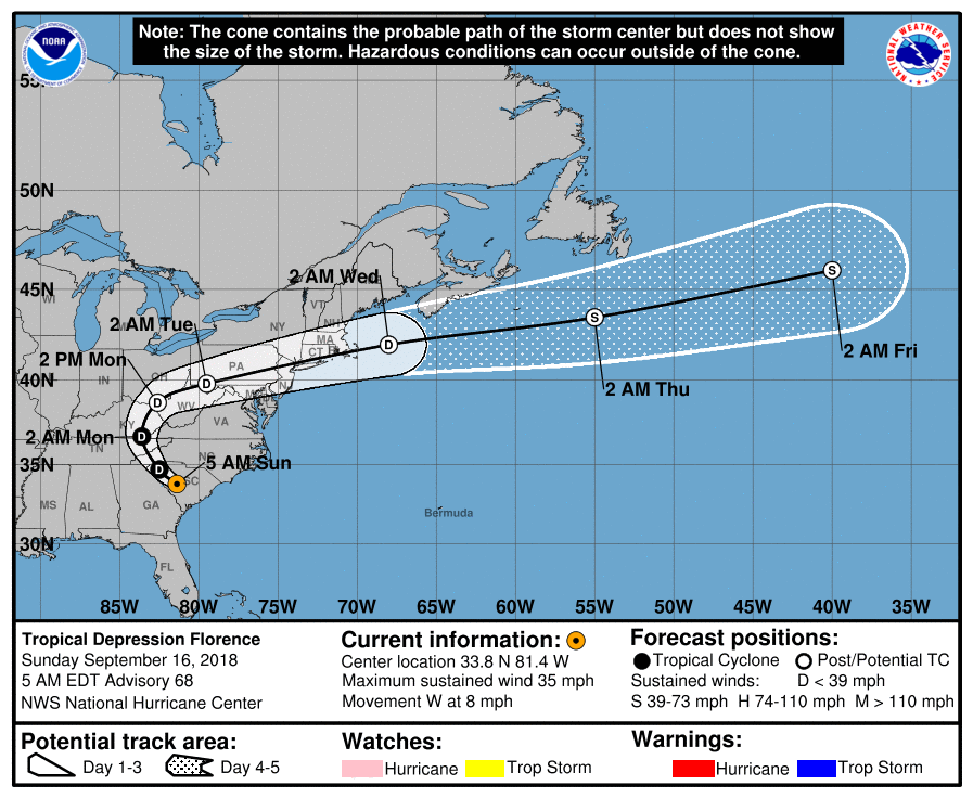
Tropical Depression Florence Discussion Number 68
NWS National Hurricane Center Miami FL AL062018
500 AM EDT Sun Sep 16 2018
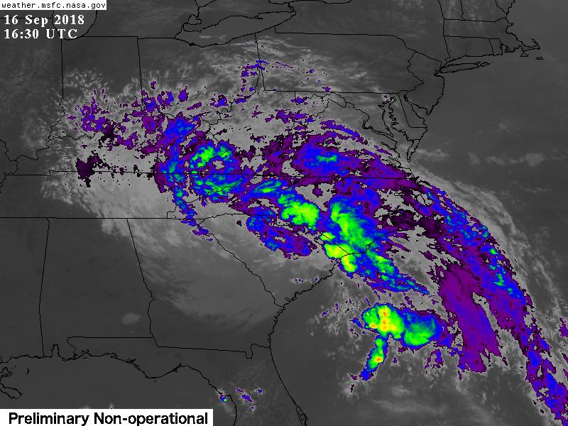
Surface observations indicate that there are no longer any
sustained tropical-storm-force winds as the center of Florence has
moved farther inland over South Carolina. Therefore, the system is
being downgraded to a tropical depression at this time. Maximum
winds are estimated to be 30 kt. Continued gradual weakening is
likely, and the numerical guidance suggests that the cyclone
will be disorganized enough to become a remnant low in 36 hours or
so. In 72 hours, global models indicate that the system will
become an extratropical cyclone, with some strengthening due to
baroclinic processes as it moves over the Atlantic in 3-5 days.
This scenario is very similar to that from the previous advisory.
The forward speed of Florence has increased somewhat early this
morning and the motion is now near 280/7 kt. The high pressure
system that has been blocking the forward progress of Florence is
predicted to slide eastward and southeastward during the next day
or so. As a result, over the next couple of days, Florence is
expected to move northwestward, northward, and then
north-northeastward around the periphery of the high. Later in the
forecast period, Florence should accelerate east-northeastward in
the mid-latitude westerlies. The official track forecast is similar
to the previous one and close to the dynamical model consensus.
This will be the last advisory issued by the National Hurricane
Center on Florence. Future information on Florence can be found in
Public Advisories issued by the Weather Prediction Center beginning
at 11 AM EDT, under AWIPS header TCPAT1, WMO header WTNT31 KWNH,
and on the web at https://www.wpc.ncep.noaa.gov.
Key Messages:
1. Life-threatening, catastrophic flash floods and prolonged
significant river flooding are likely over portions of the Carolinas
and the southern to central Appalachians from western North Carolina
into west-central Virginia and far eastern West Virginia through
early this week, as Florence continues to move slowly inland. In
addition to the flash flood and flooding threat, landslides are also
possible in the higher terrain of the southern and central
Appalachians across western North Carolina into southwest Virginia.
2. Large swells affecting Bermuda, portions of the U.S. East Coast,
and the northwestern and central Bahamas will continue this week,
resulting in life-threatening surf and rip currents.
FORECAST POSITIONS AND MAX WINDS
INIT 16/0900Z 33.8N 81.4W 30 KT 35 MPH...INLAND
12H 16/1800Z 34.7N 82.5W 30 KT 35 MPH...INLAND
24H 17/0600Z 36.7N 83.6W 25 KT 30 MPH...INLAND
36H 17/1800Z 38.7N 82.6W 20 KT 25 MPH...POST-TROP/REMNT LOW
48H 18/0600Z 39.8N 79.5W 20 KT 25 MPH...POST-TROP/REMNT LOW
72H 19/0600Z 42.0N 68.0W 30 KT 35 MPH...POST-TROP/EXTRATROP
96H 20/0600Z 43.5N 55.0W 35 KT 40 MPH...POST-TROP/EXTRATROP
120H 21/0600Z 46.0N 40.0W 40 KT 45 MPH...POST-TROP/EXTRATROP
$$
Forecaster Pasch
NNNN


|
|