開啟輔助訪問
 找回密碼
 立即加入

06L.Fred 登陸美國佛州 深入內陸 轉化溫氣

簽到天數: 1650 天

[LV.Master]伴壇終老

2021-8-8 19:48 | 顯示全部樓層
  熱帶風暴  
編號:06 L
名稱:Fred
105059wi1cijz3cairi1ce.jpg
  基本資料  
擾動編號日期:2021 08 08 20
命名日期  :2021 08 11 11
撤編日期  :2021 08 20 08
登陸地點  :多明尼加
       古巴
       美國-佛羅里達州

  巔峰時期資料  
近中心最強風速 :50  kt ( TS )
海平面最低氣壓 :993 百帕

  擾動編號資料  
94L.INVEST.25kts.1010mb.12N.52.9W

200655kzgma0hwh1tsl9ct.jpg
NHC:30%
1. An area of low pressure is producing disorganized showers and
thunderstorms over the tropical Atlantic several hundred miles east
of the Windward Islands.  Environmental conditions are expected
to be favorable to support some gradual development, and this
system could become a tropical depression while it moves west-
northwestward at 10 to 15 mph.  The disturbance is forecast to
reach portions of the Lesser Antilles late Monday and then move
across the eastern Caribbean Sea and Greater Antilles through the
middle of this week.  Interests in those areas should monitor the
progress of this system, as it could bring locally heavy rainfall
and gusty winds to portions of that area.
* Formation chance through 48 hours...low...30 percent.
* Formation chance through 5 days...medium...40 percent.

two_atl_2d1 (19).png two_atl_5d1 (20).png
以上資料來自:NHC、颱風論壇整理製作

評分

參與人數 1水氣能量 +15 +1 收起 理由
king111807 + 15 + 1 熱帶擾動首帖

查看全部評分

回復

使用道具 舉報

簽到天數: 1650 天

[LV.Master]伴壇終老

老農民版夜神月|2021-8-9 01:58 | 顯示全部樓層
NHC展望再提升至Medium,40%
3. Showers and thunderstorms associated with a broad area of low
pressure located about a hundred miles west of the southwesternmost
Cabo Verde Islands have diminished since yesterday.  Strong
upper-level winds and cooler waters are expected to prevent the
development of this system while it moves toward the west or
west-northwest.
* Formation chance through 48 hours...low...near 0 percent.
* Formation chance through 5 days...low...near 0 percent.

two_atl_2d1 (20).png two_atl_5d1 (21).png 94L_gefs_latest.png
回復

使用道具 舉報

簽到天數: 1650 天

[LV.Master]伴壇終老

老農民版夜神月|2021-8-9 20:56 | 顯示全部樓層
NHC展望提升至High,70% two_atl_2d1 (21).png two_atl_5d1 (22).png

1. Showers and thunderstorms have become more concentrated this morning
in association with a low pressure system located about 150 miles
east of Barbados. Environmental conditions are expected to be
conducive for additional development, and a tropical depression is
likely to form later today or tonight while the low moves
west-northwestward at 10 to 15 mph.  The disturbance is forecast to
reach portions of the Lesser Antilles tonight, then move near the
Virgin Islands and Puerto Rico on Tuesday, and be near Hispaniola
around the middle of this week.  Tropical storm watches or warnings
could be required today with shorter-than-normal lead times for
portions of the Lesser Antilles, the Virgin Islands, and Puerto
Rico.  In addition, heavy rains and flooding are likely for the
Leeward Islands, Virgin Islands, and Puerto Rico.  Interests in
those areas should monitor the progress of this system.
* Formation chance through 48 hours...high...70 percent.
* Formation chance through 5 days...high...70 percent.

回復

使用道具 舉報

簽到天數: 1650 天

[LV.Master]伴壇終老

老農民版夜神月|2021-8-10 02:38 | 顯示全部樓層
FWC-N發布TCFA
WTNT21 KNGU 091600
SUBJ/TROPICAL CYCLONE FORMATION ALERT (94L)//
RMKS/1. FORMATION OF A SIGNIFICANT TROPICAL CYCLONE IS POSSIBLE
WITHIN 100 NM EITHER SIDE OF A LINE FROM 13.3N 57.7W TO 15.7N 62.5W
WITHIN THE NEXT 24 HOURS. AVAILABLE DATA DOES NOT JUSTIFY
ISSUANCE OF NUMBERED TROPICAL CYCLONE WARNINGS AT THIS TIME.
WINDS IN THE AREA ARE ESTIMATED TO BE 20 TO 25 KNOTS. METSAT
IMAGERY AT 091200Z INDICATES THAT A CIRCULATION CENTER IS LOCATED
NEAR 13.3N 57.7W. THE SYSTEM IS MOVING WEST-NORTHWESTWARD AT 13
KNOTS.
2. REMARKS:RECENT VISIBLE AND INFRARED SATELLITE IMAGERY DEPICTS
AN AREA OF INCREASED CONVECTION ASSOCIATED WITH AN AREA OF LOW
PRESSURE APPROXIMATELY 150 NM EAST OF THE BARBADOS. ENVIRONMENTAL CONDITIONS ARE CONDUCIVE FOR FURTHER DEVELOPMENT OF THE SYSTEM AND
A TROPICAL DEPRESSION IS LIKELY TO FORM WITHIN THE NEXT 24 HOURS AS
IT CONTINUES TO MOVE WEST-NORTHWESTWARD AT ABOUT 13 KT TOWARD THE
LESSER ANTILLES.
3. THIS ALERT WILL BE REISSUED, UPGRADED TO WARNING OR CANCELLED BY 101600Z.//
BT

al942021.gif 94L_gefs_latest (1).png LATEST (34).jpg
回復

使用道具 舉報

簽到天數: 1650 天

[LV.Master]伴壇終老

老農民版夜神月|2021-8-10 05:39 | 顯示全部樓層
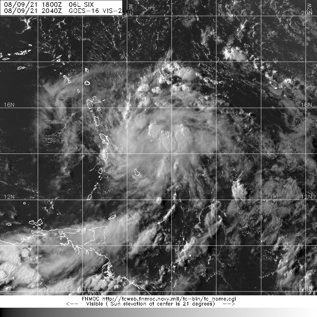
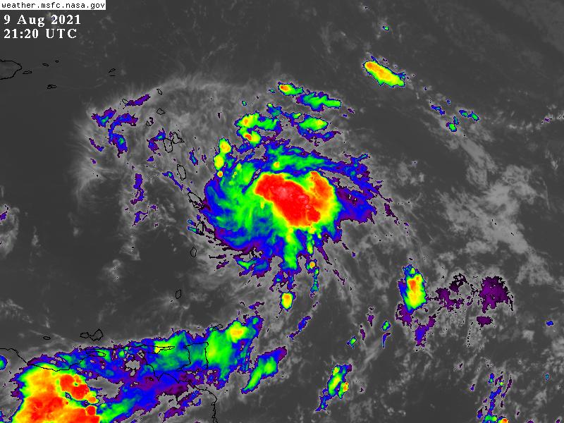
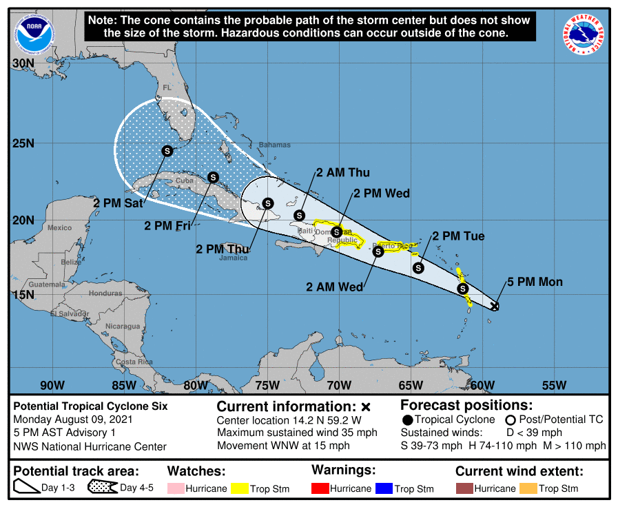
NHC升格PTC(潛在熱帶氣旋)06L
000
WTNT41 KNHC 092101
TCDAT1

Potential Tropical Cyclone Six Discussion Number   1
NWS National Hurricane Center Miami FL       AL062021
500 PM AST Mon Aug 09 2021

Deep convection associated with the area of low pressure located
northeast of Barbados has continued to consolidate this afternoon,
with several bands noted in both satellite and radar data from
Barbados and Martinique.  ASCAT data from this morning revealed a
sharp trough axis, but the system lacked a well-defined circulation.
However, recent visible satellite imagery hints that a better
defined center may be forming just southwest of the primary
convective mass.  These trends suggest the system is likely to
become a tropical depression or storm tonight or Tuesday when it
moves near the Lesser Antilles and into the eastern Caribbean.  
Therefore, advisories are being initiated on the system in order to
issue Tropical Storm Watches for portions of the Lesser Antilles,
the U.S. Virgin Islands, Puerto Rico and parts of the Dominican
Republic.

Since the system is still in its formative stage the initial motion
estimate is a somewhat uncertain 290/13 kt. A mid-tropospheric ridge
anchored over the western Atlantic should steer the system
west-northwestward through the forecast period.  Although there is
high confidence in the overall steering pattern over the next
several days, there is lower than normal confidence in the details
of the track forecast, especially in the short-range due to the lack
of a well-defined center.  Exactly where the center forms will have
some downstream implications on the exact forecast track, especially
across the eastern Caribbean.  Regardless of the exact track,
locally heavy rainfall and gusty winds are expected to spread across
portions of the Leeward Islands, the Virgin Islands, Puerto Rico,
and the Dominican Republic over the next day or two, hence the need
for Tropical Storm Watches for portions of those areas.

The disturbance is embedded within an area of low vertical wind
shear and SSTs of around 28C. These conditions favor additional
development, but the occasional entrainment of dry mid-level air
located just west of the system is likely to prevent more rapid
organization. By Wednesday, the system is likely to be near
Hispaniola, where subtle differences in the forecast track could
have large implications on the intensity of the storm later this
week. A track directly over Hispaniola would likely significantly
disrupt the circulation, while a track more poleward of the island
could allow the system to stay more intact.  An additional caveat
beyond 48 hours is that vertical wind shear out of the southwest may
also increase, which could limit the intensity after the system
moves past Hispaniola, although uncertainty exists in how much the
shear will increase given differences between the more favorable
ECMWF and less favorable GFS model solutions. The NHC intensity
forecast brings the system up to a 45 kt tropical storm before
potential land interaction with Hispaniola and afterwards is
conservative given the possibility of additional land interaction
and less favorable environmental conditions towards the end of the
forecast period.

KEY MESSAGES:

1. The system is forecast to become a tropical storm as it moves
through the Lesser Antilles tonight.  Tropical storm conditions are
possible in portions of the southern Leeward Islands tonight and
Tuesday and in the Virgin Islands and Puerto Rico beginning Tuesday
afternoon, and in the Dominican Republic by Wednesday.

2. Heavy rainfall could lead to flash, urban, and small stream
flooding and potential mudslides across the U.S. Virgin Islands and
Puerto Rico. The greatest threat for flooding impacts will be across
the eastern and southeastern portions of Puerto Rico.

3. There is a risk of wind and rainfall impacts in portions of
Hispaniola, the Turks and Caicos, the southeastern Bahamas, and Cuba
later this week, although the forecast is more uncertain than usual
since the system is still in its formative stage. Interests in these
areas should monitor the system's progress and updates to the
forecast.

4. Interests in the remainder of the Bahamas and Florida should
monitor updates to the forecast for this system, but it is too soon
to determine what if any impacts could occur there by late this week
or this weekend given the uncertainty in the long-range forecast.

FORECAST POSITIONS AND MAX WINDS

INIT  09/2100Z 14.2N  59.2W   30 KT  35 MPH...POTENTIAL TROP CYCLONE
12H  10/0600Z 15.4N  61.4W   35 KT  40 MPH...TROPICAL CYCLONE
24H  10/1800Z 16.8N  64.5W   40 KT  45 MPH
36H  11/0600Z 17.9N  67.3W   45 KT  50 MPH
48H  11/1800Z 19.2N  70.2W   35 KT  40 MPH...INLAND
60H  12/0600Z 20.3N  72.8W   35 KT  40 MPH...OVER WATER
72H  12/1800Z 21.1N  75.0W   35 KT  40 MPH
96H  13/1800Z 22.8N  78.8W   40 KT  45 MPH
120H  14/1800Z 24.5N  82.0W   40 KT  45 MPH

$$
Forecaster Brown/Papin
210624_5day_cone_no_line_and_wind.png 20210809.2040.goes-16.vis.2km.06L.SIX.30kts.1010mb.13.8N.58.6W.pc.jpg GOES212020212215NR9gm.jpg
回復

使用道具 舉報

簽到天數: 1650 天

[LV.Master]伴壇終老

老農民版夜神月|2021-8-11 10:51 | 顯示全部樓層
NHC升格TS,命名Fred 20212230200_GOES16-ABI-FL-GEOCOLOR-AL062021-1000x1000.jpg GOES02402021223BuCtus.jpg
994
WTNT21 KNHC 110247
TCMAT1

TROPICAL STORM FRED FORECAST/ADVISORY NUMBER   6
NWS NATIONAL HURRICANE CENTER MIAMI FL       AL062021
0300 UTC WED AUG 11 2021

CHANGES IN WATCHES AND WARNINGS WITH THIS ADVISORY...

NONE.

SUMMARY OF WATCHES AND WARNINGS IN EFFECT...

A TROPICAL STORM WARNING IS IN EFFECT FOR...
* PUERTO RICO...INCLUDING CULEBRA AND VIEQUES
* U.S. VIRGIN ISLANDS
* DOMINICAN REPUBLIC ON THE SOUTH COAST FROM PUNTA PALENQUE
EASTWARD AND ON THE NORTH COAST FROM CABO FRANCES VIEJO EASTWARD

A TROPICAL STORM WATCH IS IN EFFECT FOR...
* DOMINICAN REPUBLIC ON THE NORTH COAST FROM CABO FRANCES VIEJO TO
THE DOMINICAN REPUBLIC/HAITI BORDER
* HAITI FROM THE NORTHERN BORDER WITH THE DOMINICAN REPUBLIC TO
GONAIVES
* TURKS AND CAICOS ISLANDS
* SOUTHEASTERN BAHAMAS

A TROPICAL STORM WARNING MEANS THAT TROPICAL STORM CONDITIONS ARE
EXPECTED SOMEWHERE WITHIN THE WARNING AREA...IN THIS CASE WITHIN
THE NEXT 12 HOURS.

A TROPICAL STORM WATCH MEANS THAT TROPICAL STORM CONDITIONS ARE
POSSIBLE WITHIN THE WATCH AREA.

INTERESTS ELSEWHERE IN HAITI AND THE BAHAMAS...AS WELL AS IN EASTERN
AND CENTRAL CUBA...SHOULD MONITOR THE PROGRESS OF THIS SYSTEM.

TROPICAL STORM CENTER LOCATED NEAR 17.4N  66.8W AT 11/0300Z
POSITION ACCURATE WITHIN  20 NM

PRESENT MOVEMENT TOWARD THE WEST OR 270 DEGREES AT  15 KT

ESTIMATED MINIMUM CENTRAL PRESSURE 1009 MB
MAX SUSTAINED WINDS  35 KT WITH GUSTS TO  45 KT.
34 KT....... 40NE   0SE   0SW   0NW.
WINDS AND SEAS VARY GREATLY IN EACH QUADRANT.  RADII IN NAUTICAL
MILES ARE THE LARGEST RADII EXPECTED ANYWHERE IN THAT QUADRANT.

REPEAT...CENTER LOCATED NEAR 17.4N  66.8W AT 11/0300Z
AT 11/0000Z CENTER WAS LOCATED NEAR 17.4N  66.1W

FORECAST VALID 11/1200Z 18.6N  68.9W...INLAND
MAX WIND  40 KT...GUSTS  50 KT.
34 KT... 40NE   0SE   0SW  40NW.

FORECAST VALID 12/0000Z 19.9N  71.4W...INLAND
MAX WIND  35 KT...GUSTS  45 KT.
34 KT... 40NE   0SE   0SW  40NW.

FORECAST VALID 12/1200Z 20.9N  73.7W...OVER WATER
MAX WIND  35 KT...GUSTS  45 KT.
34 KT... 40NE   0SE   0SW  40NW.

FORECAST VALID 13/0000Z 21.8N  76.0W
MAX WIND  35 KT...GUSTS  45 KT.
34 KT... 40NE   0SE   0SW  40NW.

FORECAST VALID 13/1200Z 22.8N  78.0W
MAX WIND  35 KT...GUSTS  45 KT.
34 KT... 50NE   0SE   0SW  50NW.

FORECAST VALID 14/0000Z 23.8N  79.9W
MAX WIND  40 KT...GUSTS  50 KT.
34 KT... 60NE  30SE   0SW  50NW.

EXTENDED OUTLOOK. NOTE...ERRORS FOR TRACK HAVE AVERAGED NEAR 150 NM
ON DAY 4 AND 175 NM ON DAY 5...AND FOR INTENSITY NEAR 15 KT EACH DAY

OUTLOOK VALID 15/0000Z 26.5N  82.8W
MAX WIND  45 KT...GUSTS  55 KT.

OUTLOOK VALID 16/0000Z 29.3N  84.6W
MAX WIND  55 KT...GUSTS  65 KT.

REQUEST FOR 3 HOURLY SHIP REPORTS WITHIN 300 MILES OF 17.4N  66.8W

INTERMEDIATE PUBLIC ADVISORY...WTNT31 KNHC/MIATCPAT1...AT 11/0600Z

NEXT ADVISORY AT 11/0900Z

$$
FORECASTER STEWART

回復

使用道具 舉報

簽到天數: 1650 天

[LV.Master]伴壇終老

老農民版夜神月|2021-8-12 08:02 | 顯示全部樓層
已暫時登陸,NHC00Z暫將其降格為TD
000
WTNT31 KNHC 112347
TCPAT1

BULLETIN
Tropical Depression Fred Intermediate Advisory Number 9A
NWS National Hurricane Center Miami FL       AL062021
800 PM EDT Wed Aug 11 2021

...FRED WEAKENS TO A TROPICAL DEPRESSION OVER CENTRAL HISPANIOLA...
...HEAVY RAINS CONTINUE OVER HAITI AND THE DOMINICAN REPUBLIC...


SUMMARY OF 800 PM EDT...0000 UTC...INFORMATION
----------------------------------------------
LOCATION...19.2N 71.6W
ABOUT 55 MI...85 KM SE OF CAP HAITIEN HAITI
ABOUT 170 MI...275 KM SE OF GREAT INAGUA ISLAND
MAXIMUM SUSTAINED WINDS...35 MPH...55 KM/H
PRESENT MOVEMENT...WNW OR 300 DEGREES AT 15 MPH...24 KM/H
MINIMUM CENTRAL PRESSURE...1009 MB...29.80 INCHES
234805_5day_cone_no_line_and_wind.png 20212232340_GOES16-ABI-FL-GEOCOLOR-AL062021-1000x1000.jpg
回復

使用道具 舉報

簽到天數: 3279 天

[LV.Master]伴壇終老

t02436|2021-8-14 00:25 | 顯示全部樓層
中心已出海進入北大西洋,未來重整後將自佛州西岸北上,二次巔峰上望45節。
326
WTNT41 KNHC 131451
TCDAT1

Tropical Depression Fred Discussion Number  16
NWS National Hurricane Center Miami FL       AL062021
1100 AM EDT Fri Aug 13 2021

Fred remains disorganized this morning.  The low-level center,
which is currently over the barrier islands of the north coast of
Cuba, is exposed to the northwest of the main convective mass due
to moderate southwesterly vertical shear.  Reports from Air Force
Reserve and NOAA Hurricane hunter aircraft show winds of 25-30 kt
to the northeast of the center, so the initial intensity remains
30 kt.  The central pressure is 1013 mb based on a combination of
aircraft data and surface observations.

The center has jogged a bit to the left during the past several
hours, which has brought it to the Cuban coast.  The longer-term
initial motion is 295/10.  The cyclone should continue
west-northwestward for the next 12-24 h, followed by a turn toward
the northwest as Fred approaches the western periphery of the
subtropical ridge.  This motion should take the center along the
northern coast of Cuba today, near the Florida Keys and the
southwestern coast of Florida on Saturday, and near or over the
coast of the Florida Panhandle Sunday night or Monday.  After that,
a northward turn is expected as Fred moves into a weakness in the
ridge over the southeastern United States.  With both the initial
position and the track guidance shifting westward since the last
advisory, the new forecast track is also nudged a little to the
west.  The new track is east of the consensus models, especially
from 24-60 h, and thus some additional adjustments could occur
later today if the current model trends continue.

Fred is continuing to experience about 20 kt of westerly or
southwesterly vertical wind shear, and these conditions should
continue for at least another 24 hours.  Between that and land
interaction, the intensity forecast calls for only modest
strengthening during this time.  After that, there is still
relatively poor agreement on how much shear Fred will experience as
it crosses the eastern Gulf of Mexico, with the ECMWF and the UKMET
forecasting less shear than the GFS and CMC global models.  Due to
the uncertainty, the intensity forecast will keep the previous peak
intensity of 45 kt.  However, the intensity guidance during this
period has trended a little higher, and the 45 kt peak is now a
little below the upper edge of the guidance.

It should be noted that much of the Florida peninsula is expected
to be on the east side of Fred, which is where the heaviest rains,
strongest winds, and a chance of tornadoes will be.

KEY MESSAGES:

1. Today through Monday, heavy rainfall could lead to areal, urban,
small stream, and exacerbated river flooding across southern and
central Florida into the Big Bend.  From Sunday onward, heavy rain
and flood impacts could extend into other portions of the Southeast
and into the southern and central Appalachians and Piedmont as Fred
interacts with a front in that area.

2. Tropical storm conditions are expected in portions of the
Florida Keys on Saturday, where a Tropical Storm Warning is in
effect.

3. Tropical storm conditions are possible late Saturday and
early Sunday across portions of the west coast of Florida in the
Tropical Storm Watch area. The risk of tropical storm conditions
will spread northward along the Florida west coast and to the
Florida Panhandle Sunday and Monday.

FORECAST POSITIONS AND MAX WINDS

INIT  13/1500Z 22.3N  78.4W   30 KT  35 MPH...NEAR COAST OF CUBA
12H  14/0000Z 23.0N  79.7W   30 KT  35 MPH
24H  14/1200Z 24.2N  81.3W   35 KT  40 MPH
36H  15/0000Z 25.6N  82.5W   35 KT  40 MPH
48H  15/1200Z 27.2N  83.6W   40 KT  45 MPH
60H  16/0000Z 28.7N  84.6W   45 KT  50 MPH
72H  16/1200Z 30.2N  85.4W   35 KT  40 MPH...INLAND
96H  17/1200Z 33.0N  86.5W   25 KT  30 MPH...INLAND
120H  18/1200Z 36.5N  86.5W   20 KT  25 MPH...POST-TROP/INLAND

$$
Forecaster Beven

150106_5day_cone_with_line.png

GOES16162021225EMZOG4.jpg

goes16_ir_06L.gif
回復

使用道具 舉報

123下一頁
快速回覆
您需要登錄後才可以回帖 登錄 | 立即加入

本版積分規則

本平台僅供學術討論之用,預報應以氣象局為準

威普網站虛擬主機贊助公司

臺灣第一個天氣類型社群平台 即時天氣資訊、精準颱風動態

線上客服
FB傳送訊息
廣告行銷
精準行銷 物超所值
官方粉專
發佈 快速回復 返回頂部 返回列表