開啟輔助訪問
 找回密碼
 立即加入

06L.Fred 登陸美國佛州 深入內陸 轉化溫氣

簽到天數: 1650 天

[LV.Master]伴壇終老

老農民版夜神月|2021-8-14 08:55 | 顯示全部樓層
命運坎坷,不停的撞島,要回到TS可能也得+24H後了,之後距離登陸美國有一小段的增強空間,但機構目前普遍上望也並不高
FORECAST POSITIONS AND MAX WINDS

INIT  13/2100Z 22.3N  79.6W   30 KT  35 MPH...INLAND
12H  14/0600Z 23.0N  81.0W   30 KT  35 MPH...INLAND
24H  14/1800Z 24.2N  82.6W   35 KT  40 MPH...OVER WATER
36H  15/0600Z 25.4N  83.7W   35 KT  40 MPH
48H  15/1800Z 27.0N  84.8W   40 KT  45 MPH
60H  16/0600Z 28.8N  85.7W   45 KT  50 MPH
72H  16/1800Z 30.2N  86.2W   50 KT  60 MPH
96H  17/1800Z 33.5N  86.5W   25 KT  30 MPH...INLAND
120H  18/1800Z 37.0N  85.0W   20 KT  25 MPH...POST-TROP/INLAND

234109_5day_cone_no_line_and_wind (1).png 20210814.0030.goes-16.ir.06L.FRED.30kts.1013mb.22.5N.80.2W.100pc.jpg
20210813.2348.f17.91pct91h91v.06L.FRED.30kts.1013mb.22.1N.79.1W.085pc.jpg

回復

使用道具 舉報

簽到天數: 3280 天

[LV.Master]伴壇終老

t02436|2021-8-14 23:52 | 顯示全部樓層
撞到古巴整個結構都散了...
15Z報降為強度30節的擾動,不過中心已經出海進入墨西哥灣,預計整合一天即可重新增強回TS,登陸點西修至佛州與阿拉巴馬州交界。
145243_5day_cone_with_line.png
000
WTNT41 KNHC 141450
TCDAT1

Remnants Of Fred Discussion Number  20
NWS National Hurricane Center Miami FL       AL062021
1100 AM EDT Sat Aug 14 2021

A combination of shear caused by an upper-level trough over the
Gulf of Mexico and land interaction has caused Fred to degenerate
into an open wave.  Surface observations from Cuba do not show a
closed circulation, and satellite imagery shows at least two
vorticity centers embedded in a large trough.  The strongest
convection is currently near and southeast of a vorticity center
near the Isle of Youth.  The initial position is a mean position
between the vorticity center, and the initial intensity of 30 kt is
based on Air Force Reserve Hurricane Hunter aircraft data to the
northeast of the estimated center position.

The global models forecast the upper-level trough to move northward
and weaken during the next 24 h and indicate that Fred will re-form
a closed circulation over the eastern Gulf of Mexico Sunday morning.
Given the strength of the upper-level trough, that forecast may
well be too bullish.  However, given the agreement in the guidance,
the revised intensity forecast will call for Fred to regain
tropical cyclone status at about the 24 h point, followed by gradual
strengthening in a less than ideal upper-level wind environment
until landfall along the northern Gulf coast.  After landfall, the
system should weaken and dissipate between 96-120 h.

The initial motion is a very uncertain 300/10.  The system is
expected to move west-northwestward to northwestward around the
western periphery of the subtropical ridge, with a turn toward the
north as the system nears the northern Gulf coast in 60-72 h.
While the forecast guidance is in good agreement on this general
scenario, there is uncertainty as to where the center of Fred will
be when it re-forms.  Therefore, users should not concentrate on
the details of the forecast track, which could change quite a bit
during the next 24-36 h.

Although all coastal watches and warnings are discontinued at this
time, the National Hurricane Center will continue 6-hourly
advisories on the remnants of Fred in anticipation of
re-development and the potential need for watches and warnings on
the northern Gulf coast later in the weekend.

KEY MESSAGES:

1. Today through Monday, heavy rainfall could lead to areal, urban,
and small stream flooding impacts, and cause new and renewed river
flooding, across southern Florida, the Big Bend, and Panhandle.
From Monday onward, heavy rain and flood impacts could extend into
other portions of the Southeast and into the southern and central
Appalachians and Piedmont as Fred interacts with a front in the
area.

2. Fred is forecast to regenerate as a tropical cyclone over
the Gulf of Mexico on Sunday, and bring a risk of tropical storm
conditions to portions of the northern Gulf coast, especially from
coastal Mississippi to the Florida Panhandle beginning on Monday.
Watches may be required for a portion of this area later in the
weekend.


FORECAST POSITIONS AND MAX WINDS

INIT  14/1500Z 23.3N  83.2W   30 KT  35 MPH...DISTURBANCE
12H  15/0000Z 24.1N  84.2W   30 KT  35 MPH...DISTURBANCE
24H  15/1200Z 25.7N  85.5W   30 KT  35 MPH...TROPICAL CYCLONE
36H  16/0000Z 27.4N  86.7W   35 KT  40 MPH
48H  16/1200Z 28.7N  87.4W   45 KT  50 MPH
60H  17/0000Z 30.0N  87.7W   45 KT  50 MPH
72H  17/1200Z 31.5N  87.5W   35 KT  40 MPH...INLAND
96H  18/1200Z 35.0N  86.5W   20 KT  25 MPH...POST-TROP/INLAND
120H  19/1200Z...DISSIPATED

$$
Forecaster Beven

goes16_06L_rgbvis_202108141522.png

GOES15412021226gwJzCW.jpg
回復

使用道具 舉報

簽到天數: 3280 天

[LV.Master]伴壇終老

t02436|2021-8-15 22:55 | 顯示全部樓層
15Z重回TS,36小時內登陸美國。
115353_5day_cone_with_line.png
ZCZC MIATCDAT1 ALL
TTAA00 KNHC DDHHMM

Tropical Storm Fred Discussion Number  24
NWS National Hurricane Center Miami FL       AL062021
1100 AM EDT Sun Aug 15 2021

Satellite imagery and reports from an Air Force Reserve Hurricane
Hunter aircraft indicate that the remnants of Fred have
re-developed into a tropical cyclone over the eastern Gulf of
Mexico.  Satellite imagery shows a well-defined low-level center
near the northern end of a broadly curved convective band.  The
Hurricane Hunters reported a central pressure of 1008 mb, along
with 925-mb flight-level winds of 52 kt and SFMR wind estimates
near 35 kt about 70 n mi northeast of the center.  Based on these
developments and data, the system was upgraded back to Tropical
Storm Fred a couple of hours ago.

The center re-formed northward during the redevelopment process,
and the initial position is re-located to the north of the previous
advisory position.  While the forecast guidance is basically
unchanged in calling for a north-northwest motion followed by a
turn toward the north near landfall on the northern Gulf coast, the
new initial position requires the forecast track to be shifted about
40 n mi to the east of the previous track through the landfall time.
Fred is now expected to make landfall in the western Florida
Panhandle sometime Monday afternoon or evening.

Upper-level southwesterly flow between a trough to the north and
northwest of Fred and an anticyclone to the southeast of the storm
should keep the tropical cyclone in moderate southwesterly
vertical shear until landfall.  The intensity guidance forecasts
gradual intensification before landfall, and the official intensity
forecast follows the guidance in calling for a peak intensity of
45 kt.  After landfall, Fred should quickly weaken and dissipate as
it moves into the Tennessee Valley.

Users are reminded not to focus on the exact forecast track of  
Fred, since rainfall, storm surge, and wind hazards will extend
over an area well east of the center.

KEY MESSAGES:

1. Today through Tuesday, heavy rainfall could lead to areal, urban,
small stream and river flooding impacts across southern Florida, the
Florida Big Bend and Panhandle, southern Alabama, portions of  
Georgia, and the western Carolinas.  From Tuesday onward, heavy rain
and flood impacts could continue into other portions of the
Southeast and into the southern and central Appalachians and
Piedmont as Fred interacts with a front in the area.

2. Dangerous storm surge inundation is possible along portions of
the coast of the Florida Panhandle, and a Storm Surge Warning has
been issued for this area. Interests in these areas should follow
any advice given by local officials.

3. Tropical storm conditions are expected in the Tropical Storm
Warning area in the Florida Panhandle beginning on Monday.

FORECAST POSITIONS AND MAX WINDS

INIT  15/1500Z 26.1N  84.9W   35 KT  40 MPH
12H  16/0000Z 27.4N  85.8W   40 KT  45 MPH
24H  16/1200Z 28.9N  86.5W   45 KT  50 MPH
36H  17/0000Z 30.5N  86.5W   45 KT  50 MPH...INLAND
48H  17/1200Z 32.5N  86.4W   30 KT  35 MPH...INLAND
60H  18/0000Z 34.7N  85.7W   20 KT  25 MPH...POST-TROP/INLAND
72H  18/1200Z...DISSIPATED

$$
Forecaster Beven

NNNN

goes16_vis_06L.gif

GOES14462021227YYlfMW.jpg
回復

使用道具 舉報

簽到天數: 1650 天

[LV.Master]伴壇終老

老農民版夜神月|2021-8-16 11:09 | 顯示全部樓層
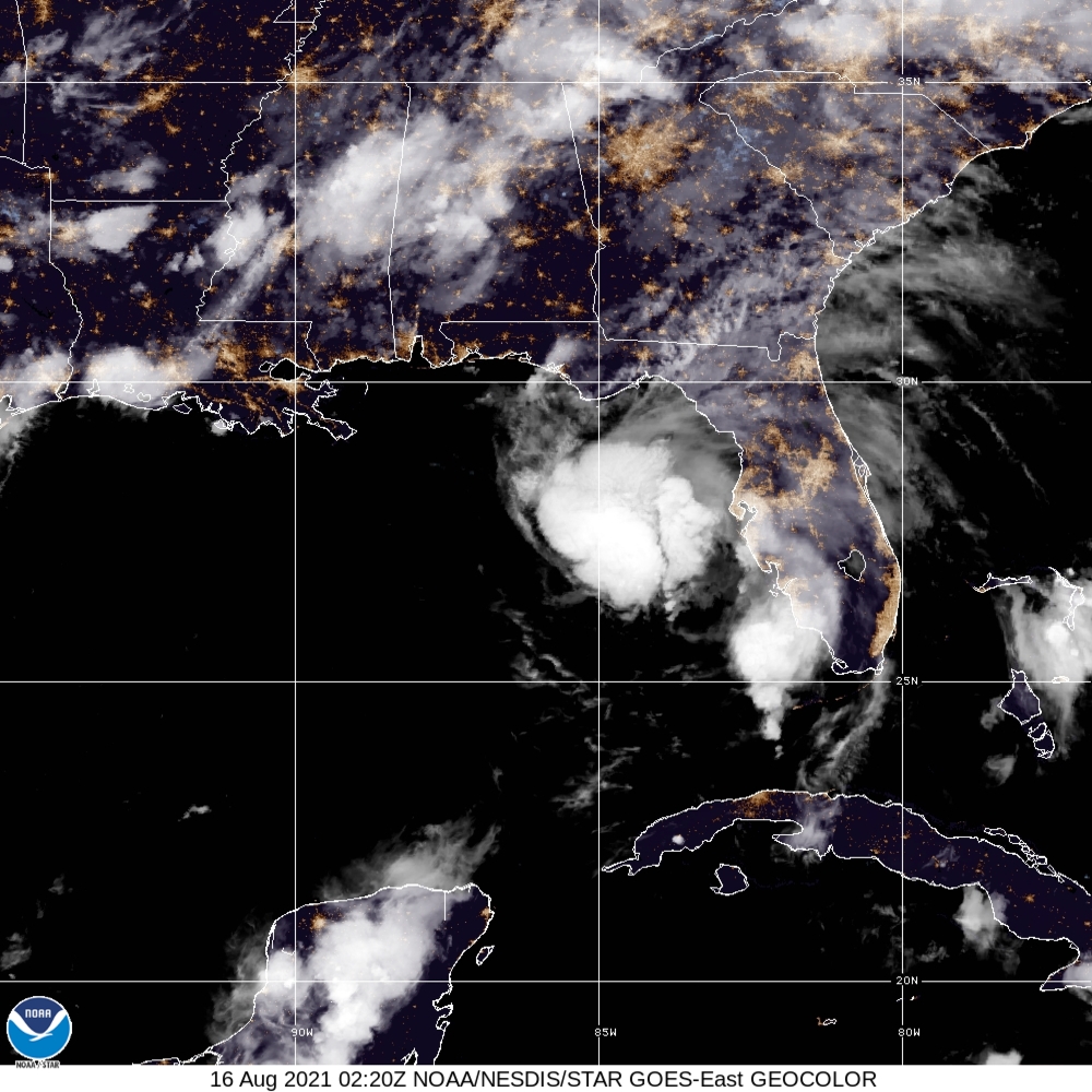
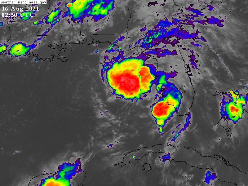
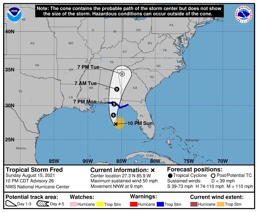
已重新增強至45KT,預計將以50KT強度登陸美國 212957_5day_cone_no_line_and_wind.png 20212280220_GOES16-ABI-FL-GEOCOLOR-AL062021-1000x1000.jpg
GOES02502021228tqAhGa.jpg

285
WTNT41 KNHC 160244
TCDAT1

Tropical Storm Fred Discussion Number  26
NWS National Hurricane Center Miami FL       AL062021
1000 PM CDT Sun Aug 15 2021

Fred remains a sheared tropical cyclone however the overall
organization of the system has improved somewhat since this
afternoon.  The low-level center is embedded near the western edge
of the primary convective mass, and there has been an overall
increase in deep convection near and to the east of the center.  An
Air Force Reserve reconnaissance aircraft that has been
investigating Fred this evening has reported that the pressure has
fallen to 999 mb and it has found winds to support an initial
intensity of 45 kt.  The plane found a very small area of slightly
stronger flight-level and SFMR winds well east of the center, but
those winds appear to have been associated with a strong convective
cell and are likely not representative of the system's overall
intensity.

Fred is moving north-northwestward or 330/08 kt, and this motion
should continue overnight.  The dynamical model guidance indicates
that the tropical cyclone will turn northward on Monday as it
approaches the coast of the Florida panhandle. A north-
northeastward motion around the western periphery of a subtropical
ridge over the western Atlantic should commence by the time the
system makes landfall, and this general heading should continue
until the system dissipates in a couple of days.  The dynamical
models envelope did not change much and the latest consensus aids
were essentially along the previous NHC track.  As a result, little
alteration was made to the previous official track forecast.

The cyclone is located within an area of moderate southwesterly
vertical wind shear. However, most of the intensity guidance
continues to suggest that Fred will strengthen a little over the
next 12-18 hours.  As the system nears the northern Gulf coast, the
SHIPS guidance forecasts some increase in shear and the intensity
models reflect this by showing a leveling off of Fred's intensity at
that time.  After landfall, Fred should weaken quickly and dissipate
over the Tennessee Valley in a little more than 48 hours. The
updated NHC intensity forecast is in good agreement within the HCCA
and IVCN consensus aids.

Users are reminded not to focus on the exact forecast track of
Fred, since rainfall, storm surge, and wind hazards will extend
over an area well east of the center.

KEY MESSAGES:

1. Through Tuesday, heavy rainfall may lead to flash, urban, small
stream, and isolated river flooding impacts across the Southeast,
including portions of southern Florida, the Big Bend and Panhandle
of Florida, southeast Alabama, portions of Georgia, and the western
Carolinas.  By the middle of the week as Fred lifts north and inland
toward the Tennessee Valley, heavy rainfall and flooding may impact
the southern and central Appalachians, and the Piedmont of the
Southeast and Mid-Atlantic.

2. Dangerous storm surge inundation is possible along portions of
the coast of the Florida Panhandle and the Florida Big Bend region,
and a Storm Surge Warning is in effect for this area. Interests in
these areas should follow any advice given by local officials.

3. Tropical storm conditions are expected in the Tropical Storm
Warning area in the Florida Panhandle beginning on Monday.


FORECAST POSITIONS AND MAX WINDS

INIT  16/0300Z 27.3N  85.9W   45 KT  50 MPH
12H  16/1200Z 28.6N  86.2W   50 KT  60 MPH
24H  17/0000Z 30.2N  86.1W   50 KT  60 MPH
36H  17/1200Z 32.3N  85.7W   30 KT  35 MPH...INLAND
48H  18/0000Z 34.4N  84.9W   20 KT  25 MPH...POST-TROP/INLAND
60H  18/1200Z...DISSIPATED

$$
Forecaster Brown

回復

使用道具 舉報

簽到天數: 3280 天

[LV.Master]伴壇終老

t02436|2021-8-17 00:12 | 顯示全部樓層
中心已在佛州南方近海,稍晚即將以55節左右強度登陸。
152153_5day_cone_with_line.png
000
WTNT41 KNHC 161500
TCDAT1

Tropical Storm Fred Discussion Number  28
NWS National Hurricane Center Miami FL       AL062021
1000 AM CDT Mon Aug 16 2021

Fred became better organized on satellite and radar images this
morning, with the center fairly well embedded within a small CDO
and a large convective band over the eastern portion of the
circulation.  The Air Force Hurricane Hunters found flight-level
winds that supported an intensity of 50 kt, and data from
the aircraft also found that the central pressure had fallen to 993
mb, although the most recent pressures appeared to have leveled
off.  The satellite and radar data also show a dry slot over the
southeastern quadrant.

Fred is over very warm waters of near 30 deg C and within a fairly
moist mid-level atmosphere.  A little more strengthening is
possible prior to landfall, but significant southwesterly shear is
likely to limit strengthening.  Also, the storm has little time
remaining over water.  The latest official intensity forecast is
similar to the LGEM guidance.

Center fixes from the Hurricane Hunters and WSR-88D data from
Tallahassee and Eglin AFB indicate that Fred is a little east of the
previous track.  It is not certain whether this is due to a slight
reformation of the center nearer to the strongest convection, but
that is certainly a possibility.  Based on the most recent fixes,
the current motion estimate is just slightly east of north, or 010/9
kt.  Fred is moving between the western side of a mid-level
subtropical high pressure area over the southwestern Atlantic and a
weak trough over the east-central United States.  A slight bend of
the track toward the north-northeast with a little acceleration is
expected during the next couple of days.  The official forecast is
just a bit to the east of the previous one, and follows the most
recent multi-model consensus.

Users are reminded not to focus on the exact forecast track of
Fred, since rainfall, storm surge, and wind hazards will extend
over an area well east of the center.

KEY MESSAGES:

1. Through Tuesday, heavy rainfall may lead to flash, urban, small
stream, and isolated river flooding impacts across the Southeast.  
By the middle of the week as Fred lifts north and inland, heavy
rainfall and flooding will impact the southern and central
Appalachians, the Piedmont of the Southeast and Mid-Atlantic.  
Landslides are possible across the mountains of North Carolina and
Blue Ridge Escarpment on Tuesday.

2. Dangerous storm surge inundation is expected along portions of
the coast of the Florida Panhandle and the Florida Big Bend region.
Preparations to protect life and property should be rushed to
completion in the Storm Surge Warning area.

3. Tropical storm conditions are occurring in the warning area and
will spread farther inland later today and tonight across portions
of the Florida Panhandle, southwestern Georgia, and southeastern
Alabama.

FORECAST POSITIONS AND MAX WINDS

INIT  16/1500Z 29.2N  85.7W   50 KT  60 MPH
12H  17/0000Z 30.5N  85.5W   55 KT  65 MPH...INLAND
24H  17/1200Z 32.6N  85.0W   30 KT  35 MPH...INLAND
36H  18/0000Z 35.0N  84.3W   25 KT  30 MPH...POST-TROP/INLAND
48H  18/1200Z 38.0N  82.5W   15 KT  15 MPH...POST-TROP/INLAND
60H  19/0000Z...DISSIPATED

$$
Forecaster Pasch

GOES160120212284HIB8l.jpg
GOES16062021228pp9gOH.jpg
goes16_rainbow_06L.gif
FRED_AF303_1506A_full.png
FRED_AF303_1506A_wind_full.png
FRED_AF303_1506A_vdm_202108161418.png
回復

使用道具 舉報

簽到天數: 1650 天

[LV.Master]伴壇終老

老農民版夜神月|2021-8-17 05:02 | 顯示全部樓層
NHC判定已於不久前以55節強度登陸佛羅里達州 152153_5day_cone_no_line_and_wind.png floater_floater_AL062021_GEOCOLOR_24fr_20210816-1656.gif
floater_floater_AL062021_Sandwich_24fr_20210816-1657.gif floater_floater_AL062021_band13_24fr_20210816-1658.gif

000
WTNT41 KNHC 162046
TCDAT1

Tropical Storm Fred Discussion Number  29
NWS National Hurricane Center Miami FL       AL062021
400 PM CDT Mon Aug 16 2021

Radar data indicate that the center of Fred made landfall in the
eastern Florida Panhandle a little while ago, and it is currently
moving farther inland.  Observations from the Air Force Hurricane
Hunters indicate that the storm reached a peak intensity of 55 kt
just before landfall.  Assuming some weakening since crossing the
coast, the current intensity estimate is 50 kt.  Fairly rapid
weakening will occur while the center moves over land, and the
cyclone will probably be reduced to tropical depression status by
tomorrow morning.  The official intensity forecast for the next day
or so is close to the latest Decay-SHIPS model guidance.

Radar fixes indicate that the motion is north-northeastward, or
020/8 kt.  During the next day or two Fred should move, with
increasing forward speed, between a mid-level subtropical high
pressure area over the southwestern Atlantic and a weak trough over
the east-central United states.  The official track forecast is
quite close to the latest NOAA corrected consensus model prediction,
HCCA.

Although it is weakening, Fred is likely to bring flooding rains
over portions of the southeastern and eastern United States during
the next couple of days.


KEY MESSAGES:

1. Through Tuesday, heavy rainfall may lead to considerable flash,
urban, small stream, and isolated river flooding impacts across
portions of the Florida Big Bend and Panhandle.  By the middle of
the week as Fred lifts north and inland, heavy rainfall and
flooding will impact the southern and central Appalachians, the
Piedmont of the Southeast and Mid-Atlantic.  Landslides are possible
across the mountains of North Carolina and Blue Ridge Escarpment on
Tuesday.

2. Dangerous storm surge inundation is ongoing along portions of
the coast of the Florida Panhandle and the Florida Big Bend region.

3. Tropical storm conditions will continue along the coastline
within the warning area over the next few hours and will continue
to spread farther inland later today and tonight across portions of
the Florida Panhandle, southwestern Georgia, and southeastern
Alabama.


FORECAST POSITIONS AND MAX WINDS

INIT  16/2100Z 29.9N  85.3W   50 KT  60 MPH...INLAND
12H  17/0600Z 31.5N  85.1W   35 KT  40 MPH...INLAND
24H  17/1800Z 34.0N  84.3W   30 KT  35 MPH...INLAND
36H  18/0600Z 37.0N  82.5W   25 KT  30 MPH...POST-TROP/INLAND
48H  18/1800Z 39.5N  80.0W   20 KT  25 MPH...POST-TROP/INLAND
60H  19/0600Z...DISSIPATED

$$
Forecaster Pasch

recon_AF303-1506A-FRED.png 20210816.1835.gpm.89pct89h89v.06L.FRED.55kts.994mb.29.5N.85.4W.060pc.jpg 20210816.1835.gpm.89hbt.06L.FRED.55kts.994mb.29.5N.85.4W.060pc.jpg
回復

使用道具 舉報

簽到天數: 1650 天

[LV.Master]伴壇終老

老農民版夜神月|2021-8-18 05:43 | 顯示全部樓層
本帖最後由 老農民版夜神月 於 2021-8-18 05:45 編輯

交由WPC發報,即將成為後熱帶氣旋 20212292100_GOES16-ABI-FL-GEOCOLOR-AL062021-1000x1000.jpg 20210817.2120.goes-16.vis.2km.06L.FRED.25kts.1009mb.33.8N.84.4W.pc.jpg Fred_rainfall.gif
GOES21362021229TAyasR.jpg
198
WTNT31 KWNH 172108 CCA
TCPAT1

BULLETIN
Tropical Depression Fred Advisory Number  33...Corrected
NWS Weather Prediction Center College Park MD   AL062021
500 PM EDT Tue Aug 17 2021

Corrected to change Thursday to Wednesday in rainfall hazards
section.

...TROPICAL DEPRESSION FRED MOVING NORTHEAST FROM THE SOUTHERN
APPALACHIANS WITH HEAVY RAIN AND A FEW TORNADOES...


SUMMARY OF 500 PM EDT...2100 UTC...INFORMATION
----------------------------------------------
LOCATION...34.7N 83.9W
ABOUT 90 MI...140 KM WSW OF ASHEVILLE NORTH CAROLINA
MAXIMUM SUSTAINED WINDS...25 MPH...35 KM/H
PRESENT MOVEMENT...NNE OR 25 DEGREES AT 23 MPH...37 KM/H
MINIMUM CENTRAL PRESSURE...1009 MB...29.80 INCHES


WATCHES AND WARNINGS
--------------------
Flood Watches are in effect for portions of north Georgia, the
western Carolinas, eastern Tennessee and Kentucky, southeast
Ohio, West Virginia, extreme southwest and northern
Virginia, Washington D.C., parts of Maryland, Pennsylvania, and New
York.

Tornado Watches are posted over much of South Carolina, western
North Carolina, and southwest Virginia.

For storm information specific to your area, including possible
inland watches and warnings, please monitor products issued by your
local National Weather Service forecast office.


DISCUSSION AND OUTLOOK
----------------------
At 500 PM EDT (2100 UTC), the center of Tropical Depression Fred
was located near latitude 34.7 North, longitude 83.9 West. The
depression is moving toward the north-northeast near 23 mph (37
km/h) and this motion is expected to continue tonight.

Maximum sustained winds are near 25 mph (35 km/h) with higher gusts.
Little change in strength is forecast during the next 48 hours.

The estimated minimum central pressure is 1009 mb (29.80 inches).


HAZARDS AFFECTING LAND
----------------------
RAINFALL:

Through Tonight...
Southern Appalachians...additional 1 to 3 inches of rain, with
isolated maximum storm totals of 10 inches.

Wednesday through Thursday night...
Central Appalachians and interior portions of the Mid-Atlantic
States into the Northeast...2 to 4 inches of rain with isolated
maximum storm totals of 6 inches expected.

Heavy rainfall across portions of the Southern and Central
Appalachians, Mid-Atlantic States, and Northeast could lead to
flash, urban, small stream and isolated river flooding impacts. An
increased risk of landslides exists across the mountains of North
Carolina as well as portions of the Blue Ridge Escarpment through
tonight.


TORNADOES:
A few tornadoes are possible through this evening
across parts of Georgia, the western Carolinas, and southwestern
Virginia.


NEXT ADVISORY
-------------
Next complete advisory at 1100 PM EDT.

$$
Forecaster Carbin

FORECAST POSITIONS AND MAX WINDS

INIT  17/2100Z 34.7N  83.9W   20 KT  25 MPH
12H  18/0600Z 37.5N  82.4W   20 KT  25 MPH...POST-TROP/INLAND
24H  18/1800Z 39.6N  79.0W   20 KT  25 MPH...POST-TROP/INLAND
36H  19/0600Z 41.5N  76.5W   20 KT  25 MPH...POST-TROP/INLAND
48H  19/1800Z 42.4N  73.3W   20 KT  25 MPH...POST-TROP/EXTRATROP
60H  20/0600Z 42.8N  70.2W   25 KT  30 MPH...POST-TROP/EXTRATROP

回復

使用道具 舉報

簽到天數: 1650 天

[LV.Master]伴壇終老

老農民版夜神月|2021-8-19 05:36 | 顯示全部樓層
06L_BAND01.gif
已轉化成為溫帶氣旋
FORECAST POSITIONS AND MAX WINDS

INIT  18/2100Z 40.8N  79.0W   20 KT  25 MPH...POST-TROP/EXTRATROP
12H  19/0600Z 42.1N  76.7W   20 KT  25 MPH...POST-TROP/EXTRATROP
24H  19/1800Z 42.6N  73.8W   20 KT  25 MPH...POST-TROP/EXTRATROP
36H  20/0600Z 43.6N  70.2W   25 KT  30 MPH...POST-TROP/EXTRATROP
GOES21312021230sRNUQW.jpg 20210818.2056.f16.91pct91h91v.06L.FRED.20kts.1014mb.40.4N.79.7W.075pc.jpg
回復

使用道具 舉報

快速回覆
您需要登錄後才可以回帖 登錄 | 立即加入

本版積分規則

本平台僅供學術討論之用,預報應以氣象局為準

威普網站虛擬主機贊助公司

臺灣第一個天氣類型社群平台 即時天氣資訊、精準颱風動態

線上客服
FB傳送訊息
廣告行銷
精準行銷 物超所值
官方粉專
發佈 快速回復 返回頂部 返回列表