開啟輔助訪問
 找回密碼
 立即加入

09L.Ida 墨灣猛爆增強 巔峰曾達C4 重創美國已56死

簽到天數: 1650 天

[LV.Master]伴壇終老

2021-8-25 06:12 | 顯示全部樓層
  四級颶風  
編號:09 L
名稱:Ida
20210829.1230.goes-16.vis.2km.09L.IDA.130kts.929mb.28.5N.89.6W.pc.jpg
  基本資料  
擾動編號日期:2021 08 25 06
命名日期  :2021 08 27 05
撤編日期  :2021 09 03 20
登陸地點  :古巴

                       美國-路易斯安那州

  巔峰時期資料  
近中心最強風速 :130  kt (
Cat.4 )
海平面最低氣壓 :935 百帕

  擾動編號資料  

99L.INVEST.20kts.1018mb.11N.68W
20210824.2140.goes-16.vis.2km.99L.INVEST.20kts.1018mb.11N.68W.pc.jpg
NHC:10%
1. A broad area of low pressure is expected to form over the
southwestern Caribbean Sea in a couple of days from a tropical wave
currently located over the central Caribbean Sea.  Environmental
conditions are forecast to be conducive for development of the low
if it remains over water, and a tropical depression could form late
this week or this weekend while the system moves northwestward over
the northwestern Caribbean Sea, across the Yucatan Peninsula of
Mexico, and into the southwestern Gulf of Mexico by Sunday.
* Formation chance through 48 hours...low...10 percent.
* Formation chance through 5 days...medium...60 percent.

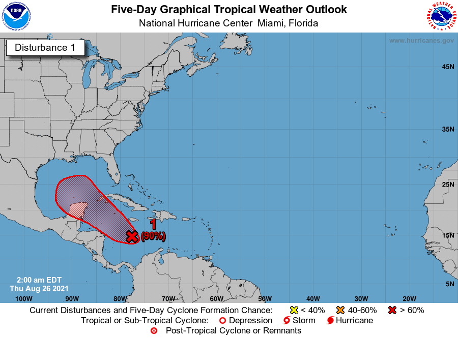
two_atl_2d1 (31).png two_atl_5d1 (32).png 以上資料來自:NHC、颱風論壇整理製作

評分

參與人數 1水氣能量 +15 +1 收起 理由
t02436 + 15 + 1

查看全部評分

回復

使用道具 舉報

簽到天數: 1650 天

[LV.Master]伴壇終老

老農民版夜神月|2021-8-26 02:04 | 顯示全部樓層
本帖最後由 老農民版夜神月 於 2021-8-26 02:06 編輯

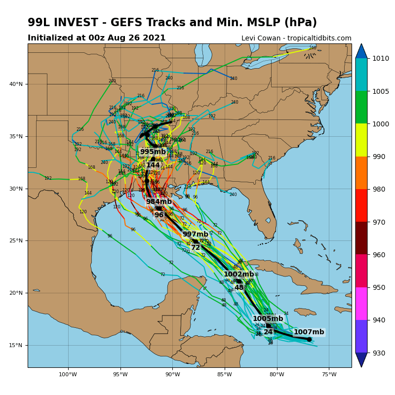
NHC展望提升至Medium,50%/80% 99L_gefs_latest.png

two_atl_2d1 (32).png two_atl_5d1 (33).png
LATEST (45).jpg
1. A broad area of low pressure is expected to form over the
southwestern Caribbean Sea during the next day or so from a tropical
wave currently located north of Colombia. Environmental conditions
are forecast to be conducive for development, and a tropical
depression or tropical storm is likely to form late this week or
over the weekend. The system is expected to move northwestward over
the northwestern Caribbean Sea and near or across the Yucatan
Peninsula of Mexico on Friday and into the Gulf of Mexico this
weekend where conditions are expected to be favorable for additional
development. Regardless of development, heavy rainfall and flooding
will be possible through the weekend in portions of Nicaragua,
Honduras, Guatemala, Belize, and the Yucatan Peninsula. In addition,
this system could bring dangerous impacts from storm surge, wind,
and heavy rainfall to portions of the coasts of Louisiana, Texas,
and the Mexican state of Tamaulipas late this weekend and early next
week. However, uncertainty remains large since the system has yet to
form. Interests in these areas should closely monitor the progress
of this system and ensure they have their hurricane plan in place.
An Air Force Reserve reconnaissance aircraft is scheduled to
investigate the system Thursday afternoon, if necessary.
* Formation chance through 48 hours...medium...50 percent.
* Formation chance through 5 days...high...80 percent.


回復

使用道具 舉報

簽到天數: 1650 天

[LV.Master]伴壇終老

老農民版夜神月|2021-8-26 13:58 | 顯示全部樓層
NHC展望提升至High,70%
1. Shower and thunderstorm activity is gradually becoming better
organized in association with a trough of low pressure located a
couple hundred miles south of Jamaica. While recent satellite wind
data indicate that the system does not yet have a well-defined
circulation, environmental conditions remain conducive for
additional development, and a tropical depression is expected to
form later today or tomorrow. The system is forecast to move
northwestward over the northwestern Caribbean Sea later today, near
Cuba and the Yucatan Peninsula of Mexico on Friday, and into the
Gulf of Mexico this weekend. Regardless of development, heavy
rainfall and flooding will be possible through the weekend in
portions of Central America, the Yucatan Peninsula, Jamaica, the
Cayman Islands, and Cuba.  In addition, this system could bring
dangerous impacts from storm surge, wind, and heavy rainfall to
portions of the coasts of Louisiana, Texas, and the Mexican state of
Tamaulipas late this weekend and early next week. However,
uncertainty remains large since the system has yet to form.
Interests in these areas should closely monitor the progress of this
system and ensure they have their hurricane plan in place. An Air
Force Reserve reconnaissance aircraft is scheduled to investigate
the system later today, if necessary.   
* Formation chance through 48 hours...high...80 percent.
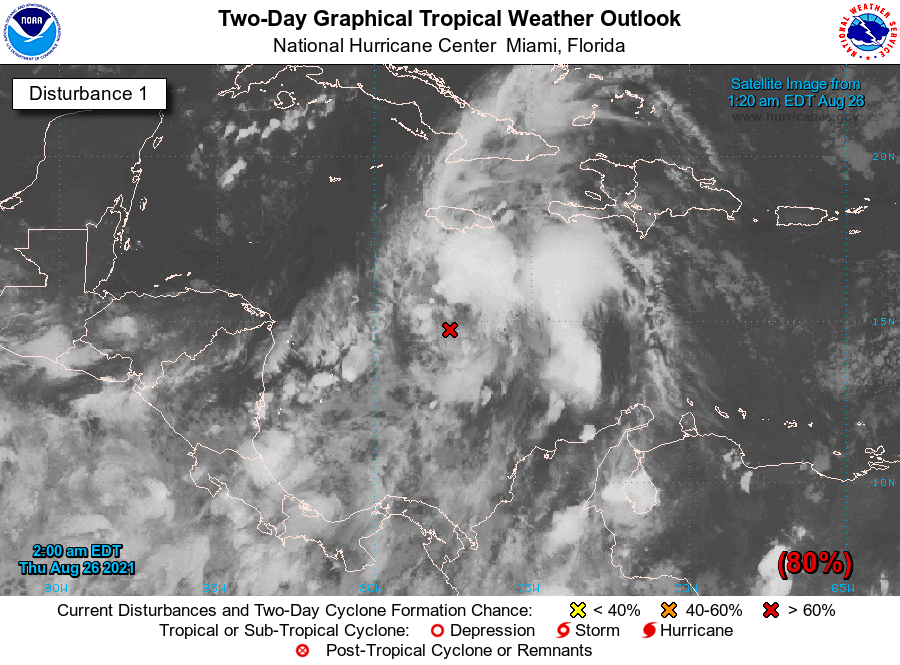
two_atl_2d1 (1).png two_atl_5d1 (1).png
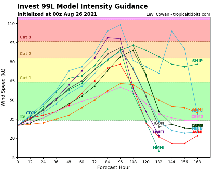
99L_gefs_latest.png 99L_intensity_latest.png
回復

使用道具 舉報

簽到天數: 1650 天

[LV.Master]伴壇終老

老農民版夜神月|2021-8-26 22:36 | 顯示全部樓層
NHC升格09L
NHC will initiate advisories on Tropical Depression Nine, located over the west-central Caribbean Sea, at 1100 AM EDT (1500 UTC).
20210826.1140.goes-16.ir.99L.INVEST.30kts.1006mb.15.1N.77.8W.100pc.jpg 99L_BAND01.gif
回復

使用道具 舉報

簽到天數: 1650 天

[LV.Master]伴壇終老

老農民版夜神月|2021-8-26 22:55 | 顯示全部樓層
本帖最後由 老農民版夜神月 於 2021-8-26 22:57 編輯

NHC看好登陸美國前強度,初報上望95KT

99L_gefs_latest (1).png 99L_intensity_latest.png
INIT  26/1500Z 16.9N  79.2W   30 KT  35 MPH
12H  27/0000Z 18.2N  80.4W   35 KT  40 MPH
24H  27/1200Z 20.3N  82.0W   45 KT  50 MPH
36H  28/0000Z 22.5N  83.9W   55 KT  65 MPH...INLAND
48H  28/1200Z 24.4N  86.0W   65 KT  75 MPH...OVER WATER
60H  29/0000Z 26.1N  88.1W   80 KT  90 MPH
72H  29/1200Z 27.7N  90.0W   95 KT 110 MPH
96H  30/1200Z 30.5N  92.0W   70 KT  80 MPH...INLAND
120H  31/1200Z 33.7N  91.2W   30 KT  35 MPH...INLAND

144701_5day_cone_no_line_and_wind.png
回復

使用道具 舉報

簽到天數: 1650 天

[LV.Master]伴壇終老

老農民版夜神月|2021-8-27 04:52 | 顯示全部樓層
翻了一下FWC-N網站,發現在升格前30分鐘左右居然發了TCFAXDD al992021.gif

SUBJ/TROPICAL CYCLONE FORMATION ALERT (99L)//
WTNT21 KNGU 261400
RMKS/
1. FORMATION OF A SIGNIFICANT TROPICAL CYCLONE IS POSSIBLE WITHIN
100 NM EITHER SIDE OF A LINE FROM 16.4N 79.0W TO 18.3N 81.0W
WITHIN THE NEXT 24 HOURS. AVAILABLE DATA DOES NOT JUSTIFY
ISSUANCE OF NUMBERED TROPICAL CYCLONE WARNINGS AT THIS TIME.
WINDS IN THE AREA ARE ESTIMATED TO BE 25 TO 30 KNOTS. METSAT
IMAGERY AT 261200Z INDICATES THAT A CIRCULATION CENTER IS LOCATED
NEAR 16.4N 79.0W. THE SYSTEM IS MOVING NORTHWEST AT 07 KNOTS.
2. REMARKS:
AN AREA OF LOW PRESSURE LOCATED ABOUT 130 NM SOUTH-SOUTHWEST OF
JAMAICA IS PRODUCING A LARGE AREA OF SHOWERS AND THUNDERSTORMS
AND SUSTAINED EASTERLY WINDS OF 25-30 KT JUST SOUTH OF THE
ISLAND. ALTHOUGH SATELLITE DERIVED WIND DATA FROM LAST NIGHT
INDICATED THAT THE SYSTEM DID NOT HAVE A CLOSED SURFACE
CIRCULATION, ENVIRONMENTAL CONDITIONS ARE CONDUCIVE FOR FURTHER
DEVELOPMENT AND A TROPICAL DEPRESSION OR STORM IS LIKELY TO FORM
LATER TODAY OR TONIGHT. THE DISTURBANCE IS FORECAST TO MOVE
NORTHWEST OVER THE NORTHWESTERN CARIBBEAN SEA DURING THE NEXT
24 HOURS AND APPROACH THE YUCATAN CHANNEL FRIDAY NIGHT.
3. THIS ALERT WILL BE REISSUED, UPGRADED TO WARNING OR CANCELLED
BY 271400Z.//
BT
回復

使用道具 舉報

簽到天數: 1650 天

[LV.Master]伴壇終老

老農民版夜神月|2021-8-27 05:40 | 顯示全部樓層
NHC特報升格TS,命名Ida 99L_CA.gif 99L_BAND01 (1).gif
20210826.1815.gw1.89pct89h89v.09L.NINE.35kts.1004mb.17.7N.79.4W.65pc.jpg
204641_5day_cone_no_line_and_wind.png

336
WTNT64 KNHC 262116
TCUAT4

Tropical Storm Ida Tropical Cyclone Update
NWS National Hurricane Center Miami FL       AL092021
520 PM EDT Thu Aug 26 2021

...AIR FORCE PLANE FINDS DEPRESSION A TROPICAL STORM...

Air Force Reserve hurricane hunter aircraft data indicate that the
depression has strengthened to Tropical Storm Ida.  The maximum
sustained winds are estimated to be 40 mph (65 km/h) with higher
gusts.


SUMMARY OF 520 PM EDT...2120 UTC...INFORMATION
----------------------------------------------
LOCATION...18.0N 79.8W
ABOUT 100 MI...160 KM WSW OF NEGRIL JAMAICA
ABOUT 130 MI...205 KM SE OF GRAND CAYMAN
MAXIMUM SUSTAINED WINDS...40 MPH...65 KM/H
PRESENT MOVEMENT...NW OR 325 DEGREES AT 14 MPH...22 KM/H
MINIMUM CENTRAL PRESSURE...1006 MB...29.71 INCHES

$$
Forecaster Brown

回復

使用道具 舉報

簽到天數: 1650 天

[LV.Master]伴壇終老

老農民版夜神月|2021-8-28 02:16 | 顯示全部樓層
NHC18Z升格一級颶風 09L_RBTOP.gif 20210827.1740.goes-16.ir.09L.IDA.50kts.996mb.20.3N.81.7W.100pc.jpg

000
WTNT34 KNHC 271743
TCPAT4

BULLETIN
Hurricane Ida Intermediate Advisory Number 5A
NWS National Hurricane Center Miami FL       AL092021
200 PM EDT Fri Aug 27 2021

...IDA MAKES LANDFALL AS A HURRICANE ON THE ISLE OF YOUTH...


SUMMARY OF 200 PM EDT...1800 UTC...INFORMATION
----------------------------------------------
LOCATION...21.6N 82.7W
ABOUT 5 MI...10 KM E OF THE CENTER OF THE ISLE OF YOUTH
ABOUT 145 MI...245 KM E OF THE WESTERN TIP OF CUBA
MAXIMUM SUSTAINED WINDS...75 MPH...120 KM/H
PRESENT MOVEMENT...NW OR 325 DEGREES AT 15 MPH...24 KM/H
MINIMUM CENTRAL PRESSURE...987 MB...29.15 INCHES
155544_5day_cone_no_line_and_wind.png 20210827.1357.mta.ASCAT.wind.09L.IDA.50kts-996mb.203N.817W.25km.noqc.jpeg
回復

使用道具 舉報

1234下一頁
快速回覆
您需要登錄後才可以回帖 登錄 | 立即加入

本版積分規則

本平台僅供學術討論之用,預報應以氣象局為準

威普網站虛擬主機贊助公司

臺灣第一個天氣類型社群平台 即時天氣資訊、精準颱風動態

線上客服
FB傳送訊息
廣告行銷
精準行銷 物超所值
官方粉專
發佈 快速回復 返回頂部 返回列表