開啟輔助訪問
 找回密碼
 立即加入

09L.Ida 墨灣猛爆增強 巔峰曾達C4 重創美國已56死

簽到天數: 1650 天

[LV.Master]伴壇終老

老農民版夜神月|2021-8-31 04:47 | 顯示全部樓層
NHC21Z降格TD,並準備將發報責任權交予WPC

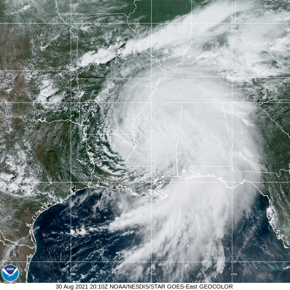
20212422010_GOES16-ABI-FL-GEOCOLOR-AL092021-1000x1000.jpg
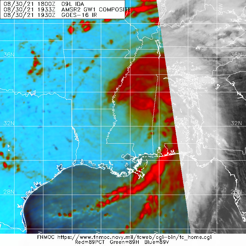
20210830.2000.goes-16.vis.2km.09L.IDA.35kts.997mb.32.2N.90.5W.pc.jpg 20210830.1933.gw1.89pct89h89v.09L.IDA.35kts.997mb.32.2N.90.5W.71pc.jpg

ZCZC MIATCDAT4 ALL
TTAA00 KNHC DDHHMM

Tropical Depression Ida Discussion Number  19
NWS National Hurricane Center Miami FL       AL092021
400 PM CDT Mon Aug 30 2021

Ida has continued to weaken while moving farther inland over
west-central Mississippi this afternoon.  Recent observations
indicate that the stronger winds seen this morning along the
northern Gulf coast have now dropped below tropical storm strength,
and Ida has become a tropical depression.  Additional weakening
should occur while Ida moves over northeastern Mississippi and the
Tennessee Valley during the next 12 to 24 hours.  Ida is forecast to
become an extratropical cyclone over the eastern United States by
late Wednesday, and it is likely to be absorbed within a frontal
boundary over the western Atlantic by the end of the forecast
period.

Ida has turned northeastward and is now moving 020/8 kt.  A
mid- to upper-level trough approaching Ida from the west should
cause the cyclone to move faster toward the northeast over the next
couple of days.  The latest runs of the dynamical models are in a
bit better agreement regarding the forward speed of the Ida as it
moves across the eastern U.S., and the NHC track forecast is again
near the middle of the guidance envelope.

Although Ida's winds have decreased, the threat of heavy rainfall
and flooding will continue to spread inland over portions of the
Tennessee and Ohio Valleys, the Central and Southern Appalachians
and the Mid-Atlantic through Wednesday.

This is the last advisory issued by the National Hurricane Center
on Ida.  Future information on this system can be found in Public
Advisories issued by the Weather Prediction Center beginning at
10 PM CDT, under AWIPS header TCPAT4, WMO header WTNT34 KWNH, and
on the web at http://www.wpc.ncep.noaa.gov.

Key Messages:

1. Ida will continue to produce heavy rainfall tonight through
Tuesday morning across portions of southeast Louisiana, Mississippi,
and western Alabama, resulting in considerable flash and urban
flooding and significant river flooding impacts. Rivers in the
Lower Mississippi Valley will remain elevated into next week. As Ida
moves inland, additional considerable flooding impacts are likely
across portions of the Tennessee Valley, the Ohio Valley, and
particularly in the Central and Southern Appalachians into the
Mid-Atlantic through Wednesday.

2. In areas that experienced damage and power loss, individuals
should use extreme caution during the recovery phase.  Post-storm
fatalities and injuries often result from heart attacks, heat
exhaustion, accidents related to clean up and recovery, and carbon
monoxide poisoning from improper generator use.


FORECAST POSITIONS AND MAX WINDS

INIT  30/2100Z 32.6N  90.3W   30 KT  35 MPH...INLAND
12H  31/0600Z 33.6N  89.3W   25 KT  30 MPH...INLAND
24H  31/1800Z 34.8N  87.2W   25 KT  30 MPH...INLAND
36H  01/0600Z 36.3N  84.3W   20 KT  25 MPH...INLAND
48H  01/1800Z 38.0N  80.7W   20 KT  25 MPH...POST-TROP/INLAND
60H  02/0600Z 39.0N  77.0W   25 KT  30 MPH...POST-TROP/EXTRATROP
72H  02/1800Z 39.5N  74.2W   30 KT  35 MPH...POST-TROP/EXTRATROP
96H  03/1800Z 41.0N  67.9W   30 KT  35 MPH...POST-TROP/EXTRATROP
120H  04/1800Z...DISSIPATED

$$
Forecaster Brown

NNNN

回復

使用道具 舉報

簽到天數: 1650 天

[LV.Master]伴壇終老

老農民版夜神月|2021-8-31 05:49 | 顯示全部樓層
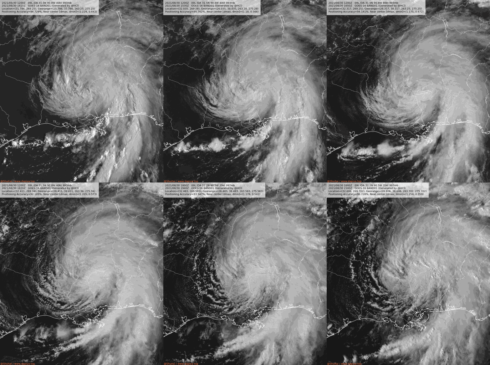
降格TD,逐漸深入美國陸地,NHC將轉交由WPC發報 152146_5day_cone_no_line_and_wind (1).png 09L_BAND01 (5).gif 20212422010_GOES16-ABI-FL-GEOCOLOR-AL092021-1000x1000 (1).jpg 20210830.1933.gw1.89pct89h89v.09L.IDA.35kts.997mb.32.2N.90.5W.71pc.jpg
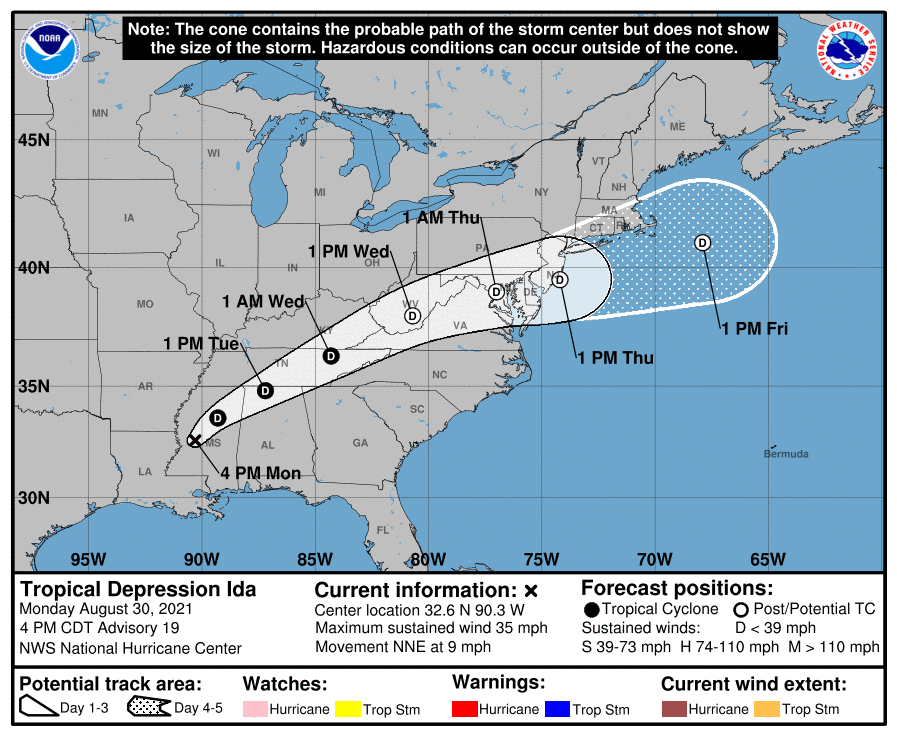
000
WTNT44 KNHC 302037
TCDAT4

Tropical Depression Ida Discussion Number  19
NWS National Hurricane Center Miami FL       AL092021
400 PM CDT Mon Aug 30 2021

Ida has continued to weaken while moving farther inland over
west-central Mississippi this afternoon.  Recent observations
indicate that the stronger winds seen this morning along the
northern Gulf coast have now dropped below tropical storm strength,
and Ida has become a tropical depression.  Additional weakening
should occur while Ida moves over northeastern Mississippi and the
Tennessee Valley during the next 12 to 24 hours.  Ida is forecast to
become an extratropical cyclone over the eastern United States by
late Wednesday, and it is likely to be absorbed within a frontal
boundary over the western Atlantic by the end of the forecast
period.

Ida has turned northeastward and is now moving 020/8 kt.  A
mid- to upper-level trough approaching Ida from the west should
cause the cyclone to move faster toward the northeast over the next
couple of days.  The latest runs of the dynamical models are in a
bit better agreement regarding the forward speed of the Ida as it
moves across the eastern U.S., and the NHC track forecast is again
near the middle of the guidance envelope.

Although Ida's winds have decreased, the threat of heavy rainfall
and flooding will continue to spread inland over portions of the
Tennessee and Ohio Valleys, the Central and Southern Appalachians
and the Mid-Atlantic through Wednesday.

This is the last advisory issued by the National Hurricane Center
on Ida.  Future information on this system can be found in Public
Advisories issued by the Weather Prediction Center beginning at
10 PM CDT, under AWIPS header TCPAT4, WMO header WTNT34 KWNH, and
on the web at http://www.wpc.ncep.noaa.gov.

Key Messages:

1. Ida will continue to produce heavy rainfall tonight through
Tuesday morning across portions of southeast Louisiana, Mississippi,
and western Alabama, resulting in considerable flash and urban
flooding and significant river flooding impacts. Rivers in the
Lower Mississippi Valley will remain elevated into next week. As Ida
moves inland, additional considerable flooding impacts are likely
across portions of the Tennessee Valley, the Ohio Valley, and
particularly in the Central and Southern Appalachians into the
Mid-Atlantic through Wednesday.

2. In areas that experienced damage and power loss, individuals
should use extreme caution during the recovery phase.  Post-storm
fatalities and injuries often result from heart attacks, heat
exhaustion, accidents related to clean up and recovery, and carbon
monoxide poisoning from improper generator use.


FORECAST POSITIONS AND MAX WINDS

INIT  30/2100Z 32.6N  90.3W   30 KT  35 MPH...INLAND
12H  31/0600Z 33.6N  89.3W   25 KT  30 MPH...INLAND
24H  31/1800Z 34.8N  87.2W   25 KT  30 MPH...INLAND
36H  01/0600Z 36.3N  84.3W   20 KT  25 MPH...INLAND
48H  01/1800Z 38.0N  80.7W   20 KT  25 MPH...POST-TROP/INLAND
60H  02/0600Z 39.0N  77.0W   25 KT  30 MPH...POST-TROP/EXTRATROP
72H  02/1800Z 39.5N  74.2W   30 KT  35 MPH...POST-TROP/EXTRATROP
96H  03/1800Z 41.0N  67.9W   30 KT  35 MPH...POST-TROP/EXTRATROP
120H  04/1800Z...DISSIPATED

$$
Forecaster Brown

回復

使用道具 舉報

簽到天數: 582 天

[LV.9]以壇為家II

蜜露|2021-9-1 00:27 | 顯示全部樓層
本帖最後由 蜜露 於 2021-9-1 08:08 編輯


颶風艾達  登陸前巔峰實測達到了  929hPa  130Kts 上下   
接近一個Cat.5

這是2018年颶風邁克爾登陸美國本土後最強的.
邁克爾好像是Cat.5  140Kts登陸  919hPa  比艾達強
20210829.1033.f16.91h.09L.IDA.115kts.949mb.27.6N.88.7W.090pc.jpg


2021al09_4kmirimg_202108291031.gif


而且這颶風還是巔峰直接登陸美國 , 路易斯安那州


登陸時間與2005年卡崔娜颶風正好同天..


而且艾達登陸的強度比卡崔娜還強.


回復

使用道具 舉報

簽到天數: 1650 天

[LV.Master]伴壇終老

老農民版夜神月|2021-9-2 03:41 | 顯示全部樓層
WPC認定Ida已成為後熱帶氣旋,驚奇一生落幕 al092021track.png 09L_BAND01 (6).gif
20210901.1605.Terra.ir.modir.IDA.1KM.jpg

000
WTNT34 KWNH 011448
TCPAT4

BULLETIN
Post-Tropical Cyclone Ida Advisory Number  26
NWS Weather Prediction Center College Park MD   AL092021
1100 AM EDT Wed Sep 01 2021

...IDA NOW EXTRATROPICAL WITH WIDESPREAD HEAVY RAIN AND AREAS OF
LIFE THREATENING FLASH FLOODING TODAY AND TONIGHT NEAR THE TRACK...
...AN ENHANCED RISK FOR SEVERAL TORNADOES ACROSS PARTS OF THE
MID-ATLANTIC THIS AFTERNOON AND EVENING...


SUMMARY OF 1100 AM EDT...1500 UTC...INFORMATION
-----------------------------------------------
LOCATION...38.3N 80.2W
ABOUT 45 MI...70 KM SSW OF ELKINS WEST VIRGINIA
ABOUT 70 MI...110 KM N OF ROANOKE VIRGINIA
MAXIMUM SUSTAINED WINDS...30 MPH...45 KM/H
PRESENT MOVEMENT...ENE OR 60 DEGREES AT 25 MPH...41 KM/H
MINIMUM CENTRAL PRESSURE...1000 MB...29.53 INCHES
回復

使用道具 舉報

簽到天數: 582 天

[LV.9]以壇為家II

蜜露|2021-9-3 09:15 | 顯示全部樓層
本帖最後由 蜜露 於 2021-9-3 09:37 編輯

艾達颶風登陸美國路易斯安娜州的威力差不多就一個蘇迪勒、尼伯特颱風登陸台灣的威力 (Cat.4 )登陸


艾達是Cat.4 的強度登陸的,其實已經超越了卡崔娜颶風在路易斯安娜州登陸的強度 Cat.3

612dbf54c3b64.image.jpg

612dbf2883ef1.image.jpg

47320673-9942719-image-a-80_1630405327444.jpg

210901093746-01-grand-isle-hurricane-ida-0831-exlarge-169.jpg

210831153330-04-hurricane-ida-0831-restricted-super-169.jpg

AP21242826493004.jpg

AP21242855295882.jpg

AP21244852786433.jpg

Ida_AP.jpg

雖然登陸美國後已經減弱為低壓了,目前北上後低壓影響在費城、紐約也在淹水中


目前有56人死亡,其中紐約有死16人與艾達有關


自從covid-19疫情爆發造成全球浩劫,其他的天災好像都只是小兒科而已.


回復

使用道具 舉報

1234
快速回覆
您需要登錄後才可以回帖 登錄 | 立即加入

本版積分規則

本平台僅供學術討論之用,預報應以氣象局為準

威普網站虛擬主機贊助公司

臺灣第一個天氣類型社群平台 即時天氣資訊、精準颱風動態

線上客服
FB傳送訊息
廣告行銷
精準行銷 物超所值
官方粉專
發佈 快速回復 返回頂部 返回列表