開啟輔助訪問
 找回密碼
 立即加入

09L.Harvey 二次登陸 德州雨量破紀錄

簽到天數: 601 天

[LV.9]以壇為家II

霧峰追風者|2017-8-24 19:37 | 顯示全部樓層
重回TS,巔峰上看Cat.1,預計巔峰登陸後將滯留打轉。
000
WTNT44 KNHC 240856
TCDAT4

Tropical Storm Harvey Discussion Number  15
NWS National Hurricane Center Miami FL       AL092017
400 AM CDT Thu Aug 24 2017

NOAA and Air Force Hurricane Hunter planes have been sampling
Harvey during the past few hours.  Both aircraft indicate that
Harvey is becoming better organized and the central pressure is
falling. An average of the flight-level winds and the SFMR yield an
initial intensity of 40 kt. There are some unconfirmed reports of
stronger winds at flight-level to the northeast of the center,
but I am waiting for the plane to go back to that area for
confirmation.

It appears that the environment has finally become favorable
and all of the guidance calls for intensification. In fact, the
Rapid Intensification Index is up to 45 percent. The current NHC
forecast is a little lower than the model consensus to maintain
continuity from the previous advisory. If the current intensity
trend continues, the winds will have to be adjusted upward
in the next advisory.

The initial motion is toward the north or 360 degrees at 9 kt.
However, this is a combination of motion and reformation under the
convection. Harvey is already on the western edge of the
subtropical ridge extending from the Atlantic westward across the
Gulf of Mexico. This pattern will steer the cyclone on a general
northwest to north-northwest track for the next 2 to 3 days. Once
Harvey makes landfall in Texas, most of the global models predict
that the steering currents will collapse and Harvey will begin to
meander over Texas and perhaps will move back into the northwestern
Gulf of Mexico.


Key Messages:

1. Harvey is likely to bring multiple hazards, including heavy
rainfall, storm surge, and possible hurricane conditions to portions
of the Texas coast beginning on Friday.

2. Heavy rainfall is likely to spread across portions of eastern
Texas, Louisiana, and the lower Mississippi Valley from Friday
through early next week and could cause life-threatening flooding.
Please refer to products from your local National Weather Service
office and the NOAA Weather Prediction Center for more information
on the flooding hazard.

3. A Storm Surge Warning is now effect from Port Mansfield to
San Luis Pass, Texas, indicating the possibility of life-threatening
inundation from rising water moving inland from the coast during the
next 36 hours.  For a depiction of areas at risk, see the Storm
Surge Watch/Warning Graphic at hurricanes.gov.

4. The Potential Storm Surge Flooding Map is available on the NHC
website.  This product depicts a reasonable worst-case scenario -
the amount of inundation that has a 10 percent chance of being
exceeded at each individual location.  Because the Flooding Map is
based on inputs that extend out only to about 72 hours, it best
represents the flooding potential in those locations within the
watch area.


FORECAST POSITIONS AND MAX WINDS

INIT  24/0900Z 23.2N  92.8W   40 KT 45 MPH
12H  24/1800Z 24.0N  93.6W   50 KT  60 MPH
24H  25/0600Z 25.1N  94.8W   60 KT  70 MPH
36H  25/1800Z 26.3N  95.8W   70 KT  80 MPH
48H  26/0600Z 27.5N  97.0W   75 KT  85 MPH
72H  27/0600Z 28.5N  97.8W   40 KT  45 MPH...INLAND
96H  28/0600Z 28.5N  97.8W   35 KT  40 MPH...INLAND
120H  29/0600Z 27.6N  97.0W   35 KT  40 MPH...INLAND

$$
Forecaster Avil

回復

使用道具 舉報

簽到天數: 3279 天

[LV.Master]伴壇終老

t02436|2017-8-25 02:03 | 顯示全部樓層
18Z加發正報,評價75節,上望110節!
000
WTNT44 KNHC 241748
TCDAT4

Hurricane Harvey Special Discussion Number  17
NWS National Hurricane Center Miami FL       AL092017
100 PM CDT Thu Aug 24 2017

This special advisory is being issued to update Harvey's initial
and forecast intensities through the 48-hour period. The storm
surge values in the public advisory have also been updated based on
the new intensity forecast.

Recent data from Air Force Reserve and NOAA Hurricane Hunter
aircraft indicate that Harvey's maximum sustained winds have
increased to 75 kt.
The Air Force plane measured maximum 850-mb
flight-level winds of 88 kt and reliable SFMR winds around 75 kt.
Based on the hurricane's current rate of intensification, the
forecast intensities at 12 and 24 h have been raised by 15 kt,
with a 10-kt increase at 36 h.  There are no changes to the track or
wind radii forecast with this special advisory.

It is critical that users not focus on the exact forecast track
of Harvey, since cycle-to-cycle adjustment are likely.  All
locations within the hurricane and storm surge warning areas should
be preparing for the possibility of major hurricane-force winds and
life-threatening storm surge.

Note that this special advisory takes the place of the scheduled
100 PM CDT (1800 UTC) intermediate advisory.

Key Messages:

1. Harvey has intensified rapidly, and is forecast to be a major
hurricane at landfall, bringing life-threatening storm surge,
rainfall, and wind hazards to portions of the Texas coast.
Preparations to protect life and property should be completed by
tonight, as tropical-storm-force winds will first arrive in the
hurricane and storm surge warning areas on Friday.

2. A Storm Surge Warning is in effect for much of the Texas coast.
Life-threatening storm surge flooding could reach heights of 6 to 12
feet above ground level at the coast between the north entrance of
the Padre Island National Seashore and Sargent. For a depiction of
areas at risk, see the Storm Surge Watch/Warning Graphic at
hurricanes.gov.

3. Life-threatening flooding is expected across much of the Texas
coast from heavy rainfall of 12 to 20 inches, with isolated amounts
as high as 30 inches, from Friday through early next week. Please
refer to products from your local National Weather Service office
and the NOAA Weather Prediction Center for more information on the
flooding hazard.

4. The Potential Storm Surge Flooding Map is available on the NHC
website. This product depicts a reasonable worst-case scenario -
the amount of inundation that has a 10 percent chance of being
exceeded at each individual location. This map best represents
the flooding potential in those locations within the watch and
warning areas.

FORECAST POSITIONS AND MAX WINDS

INIT  24/1800Z 24.4N  93.6W   75 KT  85 MPH
12H  25/0000Z 24.9N  94.2W   85 KT 100 MPH
24H  25/1200Z 26.0N  95.3W  105 KT 120 MPH
36H  26/0000Z 27.3N  96.3W  110 KT 125 MPH
48H  26/1200Z 28.3N  97.0W  100 KT 115 MPH...INLAND
72H  27/1200Z 29.0N  97.7W   40 KT  45 MPH...INLAND
96H  28/1200Z 28.5N  97.5W   35 KT  40 MPH...INLAND
120H  29/1200Z 28.5N  96.5W   30 KT  35 MPH...INLAND

$$
Forecaster Berg

152721_5day_cone_with_line.png

recon_NOAA2-1309A-HARVEY.png

recon_NOAA2-1309A-HARVEY_timeseries.png

vis-animated.gif
回復

使用道具 舉報

簽到天數: 3279 天

[LV.Master]伴壇終老

t02436|2017-8-25 13:42 | 顯示全部樓層
05Z根據實測最新回傳資料加發特報,調升強度至85節,站上二級颶風。
000
WTNT64 KNHC 250456
TCUAT4

Hurricane Harvey Tropical Cyclone Update
NWS National Hurricane Center Miami FL       AL092017
1200 AM CDT Fri Aug 25 2017

...12 AM CDT POSITION ESTIMATE...
...HARVEY STRENGTHENS TO A CATEGORY 2 HURRICANE...

Recent data from a NOAA Hurricane Hunter aircraft indicate that
Harvey has strengthened.  The estimated maximum sustained winds have
increased to near 100 mph (160 km/h).

SUMMARY OF 1200 AM CDT...0500 UTC...INFORMATION
----------------------------------------------
LOCATION...25.5N 94.9W
ABOUT 220 MI...355 KM SE OF CORPUS CHRISTI TEXAS
ABOUT 220 MI...355 KM SSE OF PORT OCONNOR TEXAS
MAXIMUM SUSTAINED WINDS...100 MPH...160 KM/H
PRESENT MOVEMENT...NW OR 315 DEGREES AT 10 MPH...17 KM/H
MINIMUM CENTRAL PRESSURE...967 MB...28.56 INCHES

$$
Forecaster Zelinsky

recon_NOAA2-1609A-HARVEY.png

recon_NOAA2-1609A-HARVEY_timeseries.png

20170825.0054.f17.91pct91h91v.09L.HARVEY.75kts.974mb.24.9N.94.3W.070pc.jpg

rbtop-animated.gif
回復

使用道具 舉報

簽到天數: 87 天

[LV.6]常住居民II

chenbo|2017-8-25 14:36 來自手機 | 顯示全部樓層
t02436 發表於 2017-8-25 02:03
18Z加發正報,評價75節,上望110節!

系統測試
回復

使用道具 舉報

簽到天數: 588 天

[LV.9]以壇為家II

Meow|2017-8-26 03:04 | 顯示全部樓層
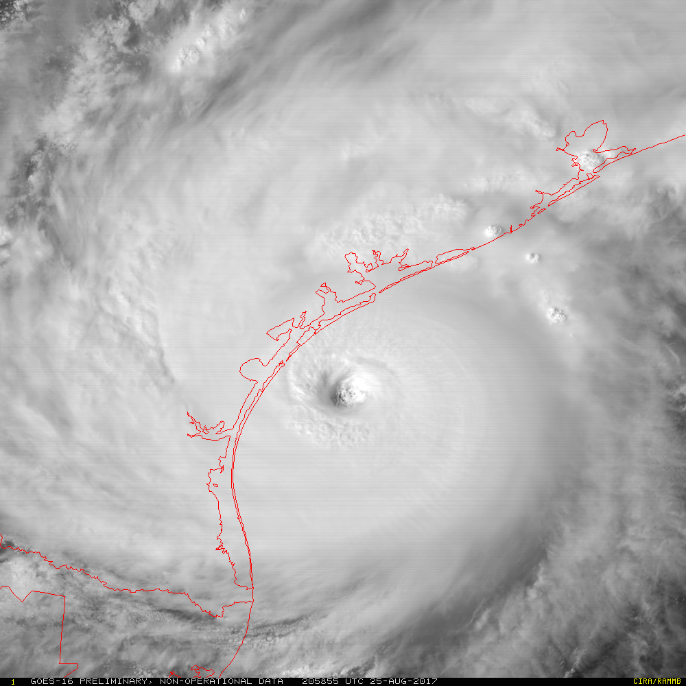
19Z特報,升格三級颶風,評價105kt,即將是2005年以來登陸美國最強颶風。
mesoscale_01_band_02_sector_05.gif
000
WTNT64 KNHC 251856
TCUAT4

Hurricane Harvey Tropical Cyclone Update
NWS National Hurricane Center Miami FL       AL092017
200 PM CDT Fri Aug 25 2017

...2 PM CDT POSITION AND INTENSITY UPDATE...
...HARVEY STRENGTHENS INTO A CATEGORY 3 HURRICANE...

Data from an Air Force Reserve Hurricane Hunter aircraft indicate
that the maximum sustained winds have increased to near 120 mph
(195 km/h) with higher gusts.  Harvey is a category 3 hurricane on
the Saffir-Simpson Hurricane Wind Scale.  The latest minimum central
pressure reported by the aircraft is 943 mb (27.85 inches).

A wind gust to 57 mph (91 km/h) was recently observed at the Naval
Air Station in Corpus Christi.  A coastal observing site near Port
Aransas has measured a sustained wind of 49 mph (80 km/h) with a
gust to 60 mph (96 km/h).

A sustained wind of 59 mph (95 km/h) and a wind gust to 69 mph
(111 km/h) were recently reported by NOAA buoy 42020, located about
40 miles off the coast of Texas.

NOAA tide gauges near Corpus Christi and Port Aransas indicate
storm surge inundation of 1 to 2 ft is already occurring.


SUMMARY OF 200 PM CDT...1900 UTC...INFORMATION
----------------------------------------------
LOCATION...27.2N 96.4W
ABOUT 75 MI...120 KM ESE OF CORPUS CHRISTI TEXAS
ABOUT 85 MI...135 KM S OF PORT OCONNOR TEXAS
MAXIMUM SUSTAINED WINDS...120 MPH...195 KM/H
PRESENT MOVEMENT...NW OR 325 DEGREES AT 10 MPH...17 KM/H
MINIMUM CENTRAL PRESSURE...943 MB...27.85 INCHES

$$
Forecaster Brown
回復

使用道具 舉報

簽到天數: 136 天

[LV.7]常住居民III

Jimmy|2017-8-26 03:52 | 顯示全部樓層
Harvey_gif.gif 從德州聖體市(Corpus Christi,TX)的雷達可清楚見到颶風Harvey正在往沿岸前進
153146_5day_cone_with_line_and_wind.png
預測Harvey將於美中時間周五至周六間登陸德州


風暴潮預警區域

風暴潮預警區域
回復

使用道具 舉報

簽到天數: 588 天

[LV.9]以壇為家II

Meow|2017-8-26 05:04 | 顯示全部樓層
三級颶風上限,相當恐怖。
153146_5day_cone_no_line_and_wind.png
000
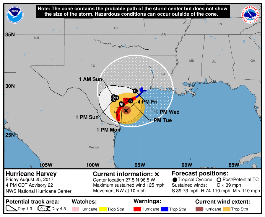
WTNT44 KNHC 252055
TCDAT4

Hurricane Harvey Discussion Number  22
NWS National Hurricane Center Miami FL       AL092017
400 PM CDT Fri Aug 25 2017

Despite its concentric eyewall structure, Harvey's winds have
increased during the day.  NOAA and Air Force Reserve Hurricane
Hunter planes have measured maximum flight-level winds of 129 kt
and SFMR winds to 102 kt.  Based on these data, Harvey's maximum
surface winds are estimated to be 110 kt.  Harvey's central pressure
has also continued to fall, and the latest estimate based on
dropsonde data is 941 mb.

Harvey still has not slowed down, and the initial estimate is
325/9 kt.  Based on the forecast track, Harvey is expected to make
landfall along the middle Texas coast tonight.  After that, the
track models insist that the hurricane will slow down considerably
during the next 24 hours, and it is likely to move very little
between 36 and 120 hours.  In fact, there has been a somewhat
notable change in the guidance, with very few of the models showing
Harvey lifting out toward the northeast by the end of the 5-day
forecast period.  As a result, the NHC track forecast has been
pulled back a bit and keeps Harvey near or just inland of the Texas
coast through the middle of next week.  This slow motion only
exacerbates the heavy rainfall and flooding threat across southern
and southeastern Texas.

Harvey may continue to strengthen during the 6-12 hours it has
before landfall, but regardless it is expected to make landfall at
major hurricane strength.  Gradual weakening is anticipated after
the center moves inland, but Harvey's slow motion will keep a
significant portion of its circulation over water, which may slow
the weakening rate.  As a result, the NHC intensity forecast leans
closer to the global model guidance instead of the statistical-
dynamical guidance, which seems to weaken Harvey too fast.  Harvey
could maintain tropical storm strength for the entire 5-day
forecast period due to its proximity to the northwestern Gulf of
Mexico.

Key Messages:

1. Harvey will make landfall tonight, bringing life-threatening
storm surge, rainfall, and wind hazards to portions of the Texas
coast. Tropical-storm-force winds have moved onshore in portions of
the warning areas and conditions will continue to deteriorate as
the eye of Harvey approaches the middle Texas coast tonight.

2. A Storm Surge Warning is in effect for much of the Texas coast.
Life-threatening storm surge flooding could reach heights of 6 to 12
feet above ground level at the coast between the north entrance of
the Padre Island National Seashore and Sargent. For a depiction of
areas at risk, see the Storm Surge Watch/Warning Graphic at
hurricanes.gov. Due to the slow motion of Harvey and a prolonged
period of onshore flow, water levels will remain elevated for
several days.

3. Catastrophic and life-threatening flooding is expected across the
middle and upper Texas coast from heavy rainfall of 15 to 30 inches,
with isolated amounts as high as 40 inches, through Wednesday.
Please refer to products from your local National Weather Service
office and the NOAA Weather Prediction Center for more information
on the flooding hazard.

FORECAST POSITIONS AND MAX WINDS

INIT  25/2100Z 27.5N  96.5W  110 KT 125 MPH
12H  26/0600Z 28.2N  97.0W  100 KT 115 MPH...INLAND
24H  26/1800Z 28.8N  97.5W   75 KT  85 MPH...INLAND
36H  27/0600Z 28.9N  97.8W   60 KT  70 MPH...INLAND
48H  27/1800Z 28.6N  97.8W   50 KT  60 MPH...INLAND
72H  28/1800Z 28.1N  96.9W   40 KT  45 MPH...INLAND
96H  29/1800Z 28.5N  96.0W   40 KT  45 MPH...OVER WATER
120H  30/1800Z 29.5N  95.5W   35 KT  40 MPH...INLAND

$$
Forecaster Berg
mesoscale_01_band_02_sector_05.gif
回復

使用道具 舉報

簽到天數: 3279 天

[LV.Master]伴壇終老

t02436|2017-8-26 07:53 | 顯示全部樓層
加發特報,評價110節,即將登陸!!
德州坐穩了....
000
WTNT64 KNHC 252259
TCUAT4

Hurricane Harvey Tropical Cyclone Update
NWS National Hurricane Center Miami FL       AL092017
600 PM CDT Fri Aug 25 2017

...6 PM CDT POSITION AND INTENSITY UPDATE...
...HARVEY BECOMES A CATEGORY FOUR HURRICANE...
...SUSTAINED HURRICANE-FORCE WINDS SPREADING ONTO THE MIDDLE TEXAS
COAST...

Air Force Reserve Reconnaissance aircraft data indicate that Harvey
has become a category 4 hurricane with maximum sustained winds of
130 mph (215 km/h).

A station at Aransas Pass run by the Texas Coastal Observing
Network recently reported a sustained wind of 74 mph (119 km/h) with
a gust to 96 mph (154 km/h).

SUMMARY OF 600 PM CDT...2300 UTC...INFORMATION
----------------------------------------------
LOCATION...27.7N 96.7W
ABOUT 45 MI...70 KM E OF CORPUS CHRISTI TEXAS
ABOUT 50 MI...85 KM SSW OF PORT OCONNOR TEXAS
MAXIMUM SUSTAINED WINDS...130 MPH...215 KM/H
PRESENT MOVEMENT...NW OR 325 DEGREES AT 8 MPH...13 KM/H
MINIMUM CENTRAL PRESSURE...941 MB...27.79 INCHES

$$
Forecaster Blake

recon_AF307-1909A-HARVEY.png
recon_AF307-1909A-HARVEY_timeseries.png

vis-animated.gif

Corpus Christi, TX Local Radar.png

點評

近岸爆發 , 美軍空軍實測出941hPa 近岸+強度 相當於彩虹颱風的等級  發表於 2017-8-26 11:18
升C4了!!!  發表於 2017-8-26 09:23
回復

使用道具 舉報

快速回覆
您需要登錄後才可以回帖 登錄 | 立即加入

本版積分規則

本平台僅供學術討論之用,預報應以氣象局為準

威普網站虛擬主機贊助公司

臺灣第一個天氣類型社群平台 即時天氣資訊、精準颱風動態

線上客服
FB傳送訊息
廣告行銷
精準行銷 物超所值
官方粉專
發佈 快速回復 返回頂部 返回列表