開啟輔助訪問
 找回密碼
 立即加入

17P.Gillian 遨遊24天 坎坷生命終落幕

簽到天數: 241 天

[LV.8]以壇為家I

krichard2011|2014-3-23 16:09 | 顯示全部樓層
本帖最後由 krichard2011 於 2014-3-23 16:12 編輯

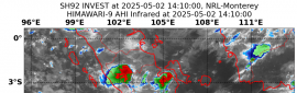
JTWC強度調升 110 KTS還差一小步就Cat.4了
基本上CDG已幾乎繞滿一圈了
結構屬於小鋼砲類型的
風眼也相當清楚
不過BOM強度保持不變 反而氣壓還調升@@
未來12小時有機會提升至100kt
不過我認為強度可能不只 不排除上看澳式Cat.5


IDW27600
TROPICAL CYCLONE TECHNICAL BULLETIN: AUSTRALIA - WESTERN REGION
Issued by PERTH TROPICAL CYCLONE WARNING CENTRE
at: 0648 UTC 23/03/2014
Name: Severe Tropical Cyclone Gillian
Identifier: 14U
Data At: 0600 UTC
Latitude: 13.7S
Longitude: 103.7E
Location Accuracy: within 20 nm [35 km]
Movement Towards: south southwest [204 deg]
Speed of Movement: 8 knots [15 km/h]
Maximum 10-Minute Wind: 90 knots [165 km/h]
Maximum 3-Second Wind Gust: 125 knots [230 km/h]
Central Pressure: 960 hPa
Radius of 34-knot winds NE quadrant: 80 nm [150 km]
Radius of 34-knot winds SE quadrant: 90 nm [165 km]
Radius of 34-knot winds SW quadrant: 80 nm [150 km]
Radius of 34-knot winds NW quadrant: 50 nm [95 km]
Radius of 48-knot winds NE quadrant: 35 nm [65 km]
Radius of 48-knot winds SE quadrant: 35 nm [65 km]
Radius of 48-knot winds SW quadrant: 35 nm [65 km]
Radius of 48-knot winds NW quadrant: 35 nm [65 km]
Radius of 64-knot winds: 20 nm [35 km]
Radius of Maximum Winds: 15 nm [30 km]
Dvorak Intensity Code: T5.5/5.5/D2.0/24HRS STT:S0.0/6HRS
Pressure of outermost isobar: 1008 hPa
Radius of outermost closed isobar: 180 nm [335 km]
FORECAST DATA
Date/Time    : Location    : Loc. Accuracy: Max Wind   : Central Pressure
[UTC]        : degrees     :      nm  [km]: knots[km/h]: hPa
+06:  23/1200: 14.4S 103.4E:     030 [060]:  090  [165]:  952
+12:  23/1800: 15.1S 103.2E:     045 [080]:  100  [185]:  947
+18:  24/0000: 15.7S 103.0E:     055 [105]:  090  [165]:  956
+24:  24/0600: 16.3S 102.8E:     070 [130]:  075  [140]:  966
+36:  24/1800: 17.3S 102.4E:     090 [165]:  050  [095]:  982
+48:  25/0600: 18.1S 101.6E:     110 [200]:  045  [085]:  992
+60:  25/1800: 18.2S 100.2E:     130 [235]:  030  [055]: 1000
+72:  26/0600: 18.3S  98.5E:     145 [270]:  025  [045]: 1004
+96:  27/0600: 18.2S  94.1E:     190 [355]:  020  [035]: 1006
+120: 28/0600:             :              :            :     
REMARKS:
Analysis position is based on animated IR imagery and the TMI pass at 03Z. An
eye has been clearly identifiable in IR throughout the day. Parallax corrections
are being applied to the apparent postiion on IR.

There is reasonable confidence in the intensity analysis. Subjective Dvorak DTs
have reached as high as 6.0 earlier today based on a B surround with +0.5 Eadj
[W/OW] but the in general the surrounding width has been insufficient for B and
has been LG with similar Eadj. Average DT is  5.5. Trend is D, MET is 4.5, PAT
is 5.0 and FT is set to average DT and remains within 1 of MET. ADT is in
general agreement. NESDIS operational version [8.1.4] has been stable at  CI of
6 for several hours,  CIMSS version 8.1.5 has been stable at 5.6 over the same
period. CIMSS AMSU based on pass at 02Z indicates 99 knots 1-min mean and SATCON
is at 100 knots 1-min mean.

本帖子中包含更多資源

您需要 登錄 才可以下載或查看,沒有賬號?立即加入

x
回復

使用道具 舉報

簽到天數: 241 天

[LV.8]以壇為家I

krichard2011|2014-3-23 18:55 | 顯示全部樓層
美又對稱
加上環繞著近乎完美的CMG環
雖然沒達到CDG環的等級
不過舊版ADT已經分析到 T# 6.9
而且似乎還再往上衝 今晚到深夜大概有機會升C4以上
不排除有機會挑戰C5
附上稍早Aqua衛星拍到的影像
風眼清晰見底結構對稱 只有"美"字可以形容


本帖子中包含更多資源

您需要 登錄 才可以下載或查看,沒有賬號?立即加入

x
回復

使用道具 舉報

簽到天數: 3733 天

[LV.Master]伴壇終老

甜心|2014-3-23 18:56 | 顯示全部樓層
17p.Gillian風暴過去一天威力不斷增強目前強度已經增強為旋風等級且開眼嚕,過去一天它發展的很順利強度威力大增而且結構越來越扎實。


本帖子中包含更多資源

您需要 登錄 才可以下載或查看,沒有賬號?立即加入

x

點評

1小時後的眼開的很清晰  發表於 2014-3-23 19:24
回復

使用道具 舉報

簽到天數: 582 天

[LV.9]以壇為家II

蜜露|2014-3-23 19:21 | 顯示全部樓層
本帖最後由 蜜露 於 2014-3-23 19:24 編輯


目前正在爆強中. 有機會挑戰前一個印度洋的Colin.

目前Dvorak分析已經到了6.7的水平


如果打開中央氣象局, 就是左下方的顯示


真不塊是黑魔女-吉莉安.  真的達到GFS的先前預測的強度= =

從卡奔塔利亞灣緩慢移動開始. 現在已經移到印度洋了

希望馬航失事的殘骸不要移到吉莉安旋風附近
(除非上演浩劫重生. 掉進無人島. 輕眼見到吉莉安的眼牆@@)

本帖子中包含更多資源

您需要 登錄 才可以下載或查看,沒有賬號?立即加入

x

點評

雖然有點難 不過要挑戰Bruce應該也不無可能...  發表於 2014-3-23 19:30
回復

使用道具 舉報

簽到天數: 241 天

[LV.8]以壇為家I

krichard2011|2014-3-23 19:38 | 顯示全部樓層
JTWC 硬是潑了一桶冷水
大概認為現在就是顛峰了
後期不再上看 不過還是要等等看12Z正報
不知道會不會提高評價 T值也在6以上
C4應該是跑不掉了... 要看還有沒有增強空間
話說這張高知大學的雲圖 照得還挺清楚的

本帖子中包含更多資源

您需要 登錄 才可以下載或查看,沒有賬號?立即加入

x

點評

記得南半球JTWC一天只會發兩報 06Z(09Z)及18Z(21Z) 等等看12Z會不會更上層樓  發表於 2014-3-23 20:39
回復

使用道具 舉報

簽到天數: 3279 天

[LV.Master]伴壇終老

t02436|2014-3-23 20:47 | 顯示全部樓層
12Z出來了
120Kts!C4達標!


本帖子中包含更多資源

您需要 登錄 才可以下載或查看,沒有賬號?立即加入

x
回復

使用道具 舉報

簽到天數: 241 天

[LV.8]以壇為家I

krichard2011|2014-3-23 20:58 | 顯示全部樓層
本帖最後由 krichard2011 於 2014-3-23 21:06 編輯

補充一下BOM 升澳式五級了@@
已經與今年伊恩平起平坐
CDO對流仍持續爆發 不排除下一報
有機會再繼續調升 不排除挑戰Bruce


SITUATION
At 1200 UTC Severe Tropical Cyclone Gillian was centred within 20 nautical
miles of
latitude fourteen decimal six south (14.6S)
longitude one hundred and three decimal seven east (103.7E)
Recent movement : south at 9 knots
Maximum winds   : 110 knots
Central pressure: 939 hPa


本帖子中包含更多資源

您需要 登錄 才可以下載或查看,沒有賬號?立即加入

x
回復

使用道具 舉報

簽到天數: 241 天

[LV.8]以壇為家I

krichard2011|2014-3-23 21:21 | 顯示全部樓層
這結構好的無話可說而且還是個針眼....
雖然BOM認定現在可能就是顛峰
不過我覺得 可能還有增強的空間
CMG環還挺完整
北側有CDG正在爆出 雖然沒有成環
對強度方面多少應該有加持


SITUATION
At 1200 UTC Severe Tropical Cyclone Gillian was centred within 20 nautical
miles of
latitude fourteen decimal six south (14.6S)
longitude one hundred and three decimal seven east (103.7E)
Recent movement : south at 9 knots
Maximum winds   : 110 knots
Central IDW27600
TROPICAL CYCLONE TECHNICAL BULLETIN: AUSTRALIA - WESTERN REGION
Issued by PERTH TROPICAL CYCLONE WARNING CENTRE
at: 1303 UTC 23/03/2014
Name: Severe Tropical Cyclone Gillian
Identifier: 14U
Data At: 1200 UTC
Latitude: 14.6S
Longitude: 103.7E
Location Accuracy: within 20 nm [35 km]
Movement Towards: south [186 deg]
Speed of Movement: 9 knots [17 km/h]
Maximum 10-Minute Wind: 110 knots [205 km/h]
Maximum 3-Second Wind Gust: 155 knots [285 km/h]
Central Pressure: 939 hPa
Radius of 34-knot winds NE quadrant: 80 nm [150 km]
Radius of 34-knot winds SE quadrant: 90 nm [165 km]
Radius of 34-knot winds SW quadrant: 90 nm [165 km]
Radius of 34-knot winds NW quadrant: 50 nm [95 km]
Radius of 48-knot winds NE quadrant: 35 nm [65 km]
Radius of 48-knot winds SE quadrant: 35 nm [65 km]
Radius of 48-knot winds SW quadrant: 35 nm [65 km]
Radius of 48-knot winds NW quadrant: 35 nm [65 km]
Radius of 64-knot winds: 20 nm [35 km]
Radius of Maximum Winds: 10 nm [20 km]
Dvorak Intensity Code: T6.5/6.5/D2.0/24HRS
Pressure of outermost isobar: 1008 hPa
Radius of outermost closed isobar: 180 nm [335 km]
FORECAST DATA
Date/Time    : Location    : Loc. Accuracy: Max Wind   : Central Pressure
[UTC]        : degrees     :      nm  [km]: knots[km/h]: hPa
+06:  23/1800: 15.4S 103.5E:     030 [060]:  110  [205]:  939
+12:  24/0000: 16.1S 103.3E:     045 [080]:  100  [185]:  949
+18:  24/0600: 16.6S 103.1E:     055 [105]:  085  [155]:  963
+24:  24/1200: 17.1S 103.0E:     070 [130]:  065  [120]:  980
+36:  25/0000: 18.3S 102.8E:     095 [175]:  050  [095]:  993
+48:  25/1200: 19.3S 102.7E:     115 [215]:  035  [065]: 1000
+60:  26/0000: 20.3S 102.4E:     140 [260]:  030  [055]: 1002
+72:  26/1200: 20.9S 102.0E:     170 [315]:  025  [045]: 1005
+96:  27/1200: 21.2S  99.7E:     210 [390]:  020  [035]: 1009
+120: 28/1200: 21.5S  96.4E:     290 [535]:  020  [035]: 1009
REMARKS:
Analysis position is based on animated IR imagery and the 0830Z SSMI pass. An
eye has been clearly identifiable in IR throughout the day. Parallax corrections
are being applied to the apparent postiion on IR.

There is reasonable confidence in the intensity analysis. Subjective Dvorak DTs
have reached 6.5 over the last 4 images and the 3 hour averaged DT is now 6.5
too. This is based on a W surround with +0.5 Eadj [CMG/OW]. Trend is D to D+,
MET is 5.5, PAT is 6.0 and FT is set to average DT and remains within 1 of MET.
ADT is in general agreement. NESDIS operational version [8.1.4] is at a CI of
6.6 and CIMSS version 8.1.5 is at 6.4 over the same period. CIMSS AMSU based on
pass at 06Z indicates 103 knots 1-min mean and SATCON was at 103 knots 1-min
mean at 06Z.pressure: 939 hPa

本帖子中包含更多資源

您需要 登錄 才可以下載或查看,沒有賬號?立即加入

x
回復

使用道具 舉報

快速回覆
您需要登錄後才可以回帖 登錄 | 立即加入

本版積分規則

本平台僅供學術討論之用,預報應以氣象局為準

威普網站虛擬主機贊助公司

臺灣第一個天氣類型社群平台 即時天氣資訊、精準颱風動態

線上客服
FB傳送訊息
廣告行銷
精準行銷 物超所值
官方粉專
發佈 快速回復 返回頂部 返回列表