|
|
離 Amanda 只差 5 節了……
000
WTPZ43 KNHC 121441
TCDEP3
HURRICANE CRISTINA DISCUSSION NUMBER 13
NWS NATIONAL HURRICANE CENTER MIAMI FL EP032014
800 AM PDT THU JUN 12 2014
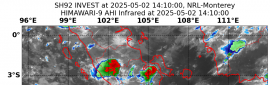
Cristina has gone through an extraordinary, but not unprecedented,
phase of rapid intensification during the past 24 hours, with its
maximum winds increasing by about 65 kt since this time yesterday.
The hurricane has a circular central dense overcast with very cold
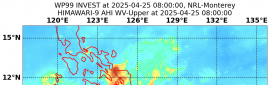
cloud tops to near -80C. Water vapor images indicate that
upper-level outflow is somewhat restricted in the southwestern
quadrant but is good elsewhere. Cristina has strengthened so fast
that TAFB and SAB satellite estimates are limited to T6.0/115 kt by
Dvorak rules. The initial intensity is set at 130 kt, a little
below the latest objective ADT estimate of T6.8/135 kt.
The intensity trend appears to have leveled off a bit, and no
further significant strengthening is expected. However, light
vertical wind shear and a deep warm ocean should allow Cristina to
maintain major hurricane strength for another 36 hours or so.
After that time, gradually increasing vertical shear and cooler sea
surface temperatures should induce significant weakening after
about 48 hours. The official intensity forecast is fairly close to
the consensus ICON and is similar to that of the special advisory.
Cristina is located to the south of a mid-level ridge centered over
northern Mexico, and the initial motion remains 295/7 kt. The
cyclone is expected to maintain a west-northwestward to
northwestward heading during the next 4 days due to the ridge, and
the track guidance is in fairly good agreement on this scenario.
The GFDL model is the primary outlier, taking Cristina farther north
after 48 hours. The official forecast sticks with the rest of the
guidance, however, and is relatively unchanged from the previous
advisory.
With Hurricanes Amanda and Cristina reaching category 4 status, this
is the first time there have been two category 4 hurricanes in June
in the eastern North Pacific basin since the beginning of the
satellite era in 1966. Prior to Cristina, the earliest second
category 4 hurricane was Hurricane Elida in 1984, which reached
that threshold on July 1.
FORECAST POSITIONS AND MAX WINDS
INIT 12/1500Z 16.6N 107.1W 130 KT 150 MPH
12H 13/0000Z 17.2N 108.2W 130 KT 150 MPH
24H 13/1200Z 17.9N 109.5W 115 KT 135 MPH
36H 14/0000Z 18.7N 110.7W 100 KT 115 MPH
48H 14/1200Z 19.2N 111.7W 85 KT 100 MPH
72H 15/1200Z 19.7N 113.1W 65 KT 75 MPH
96H 16/1200Z 20.0N 114.5W 45 KT 50 MPH
120H 17/1200Z 20.0N 117.0W 30 KT 35 MPH...POST-TROP/REMNT LOW
$$
Forecaster Berg |
本帖子中包含更多資源
您需要 登錄 才可以下載或查看,沒有賬號?立即加入
x
評分
-
查看全部評分
|