|
|
 krichard2011|2014-8-15 07:45
|
顯示全部樓層
krichard2011|2014-8-15 07:45
|
顯示全部樓層
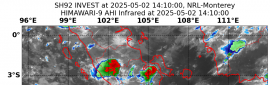
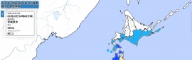
底層風眼明顯建立起來了
強度調升至Cat.1 不過受限於未來風切將顯著加強
強度只上看80KT
報文中也有提到可能跟94C產生交互作用
Despite moderate northeasterly vertical wind shear, Karina has
managed to develop a closed mid-level eye with a diameter of around
10-12 nmi since the previous advisory as noted in recent SSMI/S and
AMSU microwave imagery. Visible satellite imagery also indicates
that a cloud-filled eye has appeared in the middle of the nearly
circular CDO during past hour or so. Satellite intensity estimates
are a consensus T4.0/65 kt, and ADT estimates from UW-CIMSS ADT
have been steady at T4.4/75 kt for the past couple of hours. As a
result of these data, the intensity has been increased to 65 kt.
The initial motion estimate is 270/13 kt, which is based primarily
on passive microwave satellite position fixes. Karina's apparent
westward acceleration is likely due to the low-level center moving
or reforming underneath the well-defined mid-level eye. As a result,
this westward jog is expected to be a temporary motion, and Karina
should slow down somewhat in the near-term. Otherwise, the
hurricane is expected to remain on a basic westward track for the
next 4 days as Karina is steered by a deep-layer ridge to its north.
Afterwards, the cyclone is expected to slow down significantly and
make a turn toward the west-southwest or southwest as Karina begins
to interact with possible multiple tropical cyclones developing in
the central Pacific and eastern Pacific basins. As mentioned in the
previous discussion, rather than committing to any one particular
model solution this far out in time, the NHC track forecast instead
just shows a significant slow down in Karina's motion. The official
forecast track is just an extension of the previous advisory track,
and lies south of the consensus model TVCE, near the extreme
southern edge of the NHC guidance envelope.
The GFS-based SHIPS model indicates that the vertical shear is
expected to increase to near 20 kt during the 12-24 hour period,
while the shear vector veers around to the east. Given the
well-defined and small eye mentioned previously, some additional
strengthening is expected while Karina remains in favorable
thermodynamic and oceanic environments. By 36 hours and beyond, the
shear is forecast to decrease significantly, but this will occur
when the cyclone is moving over marginal SSTs. The result is that
a general leveling off of the intensity is expected, although there
could obviously be some fluctuations in the intensity due to
internal eyewall dynamics that can not be forecast this far in
advance. The official intensity forecast remains well above the
consensus model ICON due to the persistent weakening of Karina
shown by the GFDL and HWRF models thus far, and instead follows the
trend of the SHIPS and LGEM models.
FORECAST POSITIONS AND MAX WINDS
INIT 14/2100Z 17.1N 117.6W 65 KT 75 MPH
12H 15/0600Z 17.4N 119.1W 75 KT 85 MPH
24H 15/1800Z 17.8N 121.3W 80 KT 90 MPH
36H 16/0600Z 18.1N 123.6W 80 KT 90 MPH
48H 16/1800Z 18.2N 125.8W 80 KT 90 MPH
72H 17/1800Z 18.1N 129.5W 80 KT 90 MPH
96H 18/1800Z 17.7N 132.6W 75 KT 85 MPH
120H 19/1800Z 17.6N 134.2W 70 KT 80 MPH
$$
Forecaster Stewart |
本帖子中包含更多資源
您需要 登錄 才可以下載或查看,沒有賬號?立即加入
x
|