開啟輔助訪問
 找回密碼
 立即加入

05S.Christine 深入內陸逐漸減弱中*

簽到天數: 3279 天

[LV.Master]伴壇終老

t02436|2013-12-30 19:33 | 顯示全部樓層
中心在沿岸了
稍後即將登陸
T值還在暴衝...


本帖子中包含更多資源

您需要 登錄 才可以下載或查看,沒有賬號?立即加入

x
回復

使用道具 舉報

簽到天數: 241 天

[LV.8]以壇為家I

krichard2011|2013-12-30 19:50 | 顯示全部樓層
本帖最後由 krichard2011 於 2013-12-30 19:51 編輯

實測最大陣風出現在BEDOUT ISLAND 139 km/hr
FB已經有很多風雨的畫面傳上來

https://www.facebook.com/photo.php?v=10201074937896094


本帖子中包含更多資源

您需要 登錄 才可以下載或查看,沒有賬號?立即加入

x
回復

使用道具 舉報

簽到天數: 815 天

[LV.10]以壇為家III

martin191919|2013-12-30 20:41 | 顯示全部樓層
本帖最後由 martin191919 於 2013-12-30 20:42 編輯

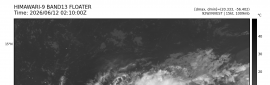
Remarks:The VERY DESTRUCTIVE inner core of Severe Tropical Cyclone Christine is now on the coast between Port Hedland and Karratha. The system is now moving further away from Port Hedland and winds there are slowly easing. In the Karratha area winds are slowly intensifying as Christine comes closer. Christine is expected to continue on a south southwest track and the centre is likely to cross the coast close to Whim Creek by about midnight.

VERY DESTRUCTIVE winds with gusts in excess of 200 kilometres per hour are likely near the centre as the cyclone crosses the coast.

DESTRUCTIVE winds with gusts in excess of 130 kilometres per hour are expected in the Karratha and Dampier region later tonight, extending well inland overnight and during Tuesday. People in Tom Price can expect destructive wind gusts to commence around 8am Tuesday morning.

GALES with gusts to 120 kilometres per hour are occurring between Wallal and Roebourne. Gales should extend west to Karratha and Dampier by this evening and then to the inland Pilbara overnight.

People on the coast between Pardoo and Wickham including Port Hedland are warned of the potential for a VERY DANGEROUS STORM TIDE tonight. Tides may rise significantly above the normal high tide mark with DAMAGING WAVES and VERY DANGEROUS COASTAL INUNDATION.

Widespread heavy rainfall is expected near the cyclone track and Flood Warnings have been issued for the Pilbara.

Gales with wind gusts to 100 kilometres per hour should extend into the eastern Gascoyne and the northern Goldfields including Wiluna later on Tuesday until the cyclone weakens overnight.
DFES State Emergency Service (SES) advises of the following community alerts:

RED ALERT: People in or near coastal areas between Pardoo and Mardie, including Port Hedland, South Hedland, Whim Creek, Roebourne, Point Samson, Wickham, Karratha and Dampier also extending inland to Tom Price and Paraburdoo. You need to immediately head to shelter and stay indoors away from doors and windows.

YELLOW alert: People in inland areas including Marble Bar, Tom Price, Paraburdoo and Pannawonica. You need to take action and get ready to shelter from the Cyclone.

BLUE ALERT: People in or near coastal areas between Wallal and Pardoo and between Mardie and Onslow and the inland area from Marble Bar to Newman and between the Collier Ranges and Three Rivers incluiding Kumarina and east to Granite Peak, need to prepare for cyclonic weather and organise an emergency kit including first aid kit, torch, portable radio, spare batteries, food and water.

ALL CLEAR WITH CAUTION: People between Bidyadanga and Wallal are advised that the threat of strong winds has passed.
回復

使用道具 舉報

簽到天數: 241 天

[LV.8]以壇為家I

krichard2011|2013-12-30 20:43 | 顯示全部樓層
本帖最後由 krichard2011 於 2013-12-30 20:50 編輯

這隻也挺奇葩的即將登陸了 眼牆不但沒有受損
還反而更加鞏固且渾圓 而且強度不減反增 0.0
又是個近岸爆發的例子...預測將在6個小時內於Whim Creek附近登陸

IDW27600
TROPICAL CYCLONE TECHNICAL BULLETIN: AUSTRALIA - WESTERN REGION
Issued by PERTH TROPICAL CYCLONE WARNING CENTRE
at: 1236 UTC 30/12/2013
Name: Severe Tropical Cyclone Christine
Identifier: 04U
Data At: 1200 UTC
Latitude: 20.3S
Longitude: 117.7E
Location Accuracy: within 15 nm [30 km]
Movement Towards: south southwest [212 deg]
Speed of Movement: 10 knots [18 km/h]
Maximum 10-Minute Wind: 85 knots [155 km/h]
Maximum 3-Second Wind Gust: 120 knots [220 km/h]
Central Pressure: 955 hPa
Radius of 34-knot winds NE quadrant: 140 nm [260 km]
Radius of 34-knot winds SE quadrant: 80 nm [150 km]
Radius of 34-knot winds SW quadrant: 70 nm [130 km]
Radius of 34-knot winds NW quadrant: 120 nm [220 km]
Radius of 48-knot winds NE quadrant: 50 nm [95 km]
Radius of 48-knot winds SE quadrant: 35 nm [65 km]
Radius of 48-knot winds SW quadrant: 35 nm [65 km]
Radius of 48-knot winds NW quadrant: 60 nm [110 km]
Radius of 64-knot winds: 25 nm [45 km]
Radius of Maximum Winds: 20 nm [35 km]
Dvorak Intensity Code: T5.5/5.0/D1.5/24HRS STT:D1.0/6HRS
Pressure of outermost isobar: 1002 hPa
Radius of outermost closed isobar: 200 nm [370 km]
FORECAST DATA
Date/Time    : Location    : Loc. Accuracy: Max Wind   : Central Pressure
[UTC]        : degrees     :      nm  [km]: knots[km/h]: hPa
+06:  30/1800: 21.1S 117.4E:     025 [045]:  070  [130]:  967
+12:  31/0000: 22.1S 117.3E:     035 [065]:  055  [100]:  979
+18:  31/0600: 23.5S 117.9E:     045 [085]:  045  [085]:  987
+24:  31/1200: 24.6S 118.9E:     055 [100]:  040  [075]:  990
+36:  01/0000: 26.9S 121.5E:     075 [140]:  030  [055]:  994
+48:  01/1200: 29.1S 125.3E:     095 [175]:  030  [055]:  996
+60:  02/0000: 31.0S 130.5E:     115 [215]:  025  [045]:  999
+72:  02/1200:             :              :            :     
+96:  03/1200:             :              :            :     
+120: 04/1200:             :              :            :     
REMARKS:
Severe TC Christine is being tracked by Port Hedland radar resulting in high
confidence fixes. Dvorak DTs  have ranged between 5.0 and 6.0 over the last 4
hours and the MET has similarly fluctuated. FT/CI is set at 5.5. The operational
ADT version [8.1.4] has increased to 5.8 in recent hours while version 8.1.5 has
increased more slowly to 5.0. Final intensity estimate is set at 85 knots 10-min
average [just below T5.5] for operational reasons.

The system will cross the coast near Whim Creek over the next 6 hours.

Although winds are gradually easing at Port Hedland the storm tide is expected
to continue to rise with the astronomical high tide at around 9pm.

The cyclone should accelerate to the southeast following landfall, following
capture by a mid level trough and remain at cyclone intensity well inland into
the eastern Gascoyne and possibly northern Goldfields. Wind and rain impacts are
therefore forecast to extend well inland on Tuesday and early Wednesday.

Copyright Commonwealth of Australia
==
The next bulletin for this system will be issued by: 30/1900 UTC by Perth TCWC.


本帖子中包含更多資源

您需要 登錄 才可以下載或查看,沒有賬號?立即加入

x
回復

使用道具 舉報

簽到天數: 815 天

[LV.10]以壇為家III

martin191919|2013-12-30 21:34 | 顯示全部樓層
JTWC 近岸的 Cat.2 強度為 85kts 即將登陸

本帖子中包含更多資源

您需要 登錄 才可以下載或查看,沒有賬號?立即加入

x
回復

使用道具 舉報

簽到天數: 241 天

[LV.8]以壇為家I

krichard2011|2013-12-30 21:39 | 顯示全部樓層
目前實測...
瞬間最大陣風出現在LEGENDRE ISLAND 141 km/hr
而最低氣壓是在 OEBOURNE AERO 978 hPa
風雨還在增強中...


本帖子中包含更多資源

您需要 登錄 才可以下載或查看,沒有賬號?立即加入

x
回復

使用道具 舉報

簽到天數: 241 天

[LV.8]以壇為家I

krichard2011|2013-12-30 22:21 | 顯示全部樓層
本帖最後由 krichard2011 於 2013-12-30 22:23 編輯

實測再度刷新
目前最大陣風及最低氣壓出現在 Roebourne Airport
分別是 150 km/hr 與 970 hPa
這個測站算是目前最靠近眼牆的


本帖子中包含更多資源

您需要 登錄 才可以下載或查看,沒有賬號?立即加入

x
回復

使用道具 舉報

簽到天數: 241 天

[LV.8]以壇為家I

krichard2011|2013-12-30 23:28 | 顯示全部樓層
實測又再度刷新了
不過氣壓下降看似已經停滯
還有微幅回升的跡象 風雨最強的看似已經過了
目前測到的最大陣風 172 km/hr 最低氣壓 958.6 hPa

本帖子中包含更多資源

您需要 登錄 才可以下載或查看,沒有賬號?立即加入

x
回復

使用道具 舉報

快速回覆
您需要登錄後才可以回帖 登錄 | 立即加入

本版積分規則

本平台僅供學術討論之用,預報應以氣象局為準

威普網站虛擬主機贊助公司

臺灣第一個天氣類型社群平台 即時天氣資訊、精準颱風動態

線上客服
FB傳送訊息
廣告行銷
精準行銷 物超所值
官方粉專
發佈 快速回復 返回頂部 返回列表