簽到天數: 815 天 [LV.10]以壇為家III
|
 martin191919|2013-12-30 23:48
|
顯示全部樓層
martin191919|2013-12-30 23:48
|
顯示全部樓層
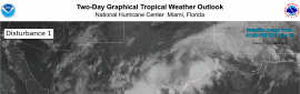
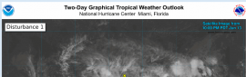
BOM預計數小時內登陸
Australian Government Bureau of Meteorology
Western Australia
Tropical Cyclone Warning Centre
Media: Transmitters serving the area between Port Hedland and Karratha are
requested to USE the Standard Emergency Warning Signal before broadcasting the
following warning.
TOP PRIORITY FOR IMMEDIATE BROADCAST
TROPICAL CYCLONE ADVICE NUMBER 38
Issued at 10:02 pm WST on Monday 30 December 2013
A Cyclone WARNING is current for coastal areas from Pardoo to Onslow, including
Port Hedland, Karratha and Onslow, and extending inland to Paraburdoo, Tom
Price, Newman, Jigalong and Three Rivers.
A Cyclone WATCH is current for areas extending further inland to the eastern
Gascoyne and northern Goldfields reaching as far as Wiluna, Leinster and
Carnegie.
The Cyclone Warning for coastal areas between Wallal and Pardoo has been
cancelled.
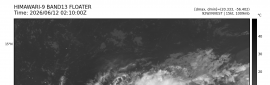
At 10:00 pm WST Severe Tropical Cyclone Christine, Category 3, was estimated to
be
120 kilometres west southwest of Port Hedland and
70 kilometres east northeast of Karratha and
moving south southwest at 18 kilometres per hour.
The VERY DESTRUCTIVE inner core of Severe Tropical Cyclone Christine is now on
the coast between Port Hedland and Karratha. The system is moving away from
Port Hedland and winds there are slowly easing. In the Karratha area winds are
intensifying as Christine comes closer. Christine is expected to continue on a
south southwest track and the centre is likely to cross the coast between Whim
Creek and Karratha during the next four hours.
VERY DESTRUCTIVE winds with gusts in excess of 200 kilometres per hour are
likely near the centre as the cyclone crosses the coast.
DESTRUCTIVE winds with gusts in excess of 130 kilometres per hour have begun in
the Karratha area and are expected to extend well inland overnight and during
Tuesday. People in Tom Price can expect destructive wind gusts to commence
around 8am Tuesday morning.
GALES with gusts to 120 kilometres per hour are occurring between Pardoo and
Mardie and will extend to the inland Pilbara overnight.
People on the coast between Pardoo and Wickham including Port Hedland are
warned of the potential for a VERY DANGEROUS STORM TIDE tonight. Tides may rise
significantly above the normal high tide mark with DAMAGING WAVES and VERY
DANGEROUS COASTAL INUNDATION.
Widespread heavy rainfall is expected near the cyclone track and Flood Warnings
have been issued for the Pilbara.
Gales with wind gusts to 100 kilometres per hour should extend into the eastern
Gascoyne and the northern Goldfields including Wiluna later on Tuesday until
the cyclone weakens late Tuesday or early Wednesday.
DFES State Emergency Service (SES) advises of the following community alerts:
RED ALERT: People in or near coastal areas between Pardoo and Mardie, including
Port Hedland, South Hedland, Whim Creek, Roebourne, Point Samson, Wickham,
Karratha and Dampier also extending inland to Tom Price and Paraburdoo. You
need to immediately head to shelter and stay indoors away from doors and
windows.
YELLOW alert: People in inland areas including Marble Bar and Pannawonica. You
need to take action and get ready to shelter from the Cyclone.
BLUE ALERT: People in or near coastal areas between Wallal and Pardoo and
between Mardie and Onslow and the inland area from Marble Bar to Newman and
between the Collier Ranges and Three Rivers incluiding Kumarina and east to
Granite Peak, need to prepare for cyclonic weather and organise an emergency
kit including first aid kit, torch, portable radio, spare batteries, food and
water.
ALL CLEAR WITH CAUTION: People between Wallal and Pardoo are advised that the
threat of strong winds has passed.
People needing SES assistance can call 132 500. In a life threatening situation
call 000. For more safety tips visit www.dfes.wa.gov.au
Details of the Severe Tropical Cyclone Christine at 10:00 pm WST:
.Centre located near...... 20.6 degrees South 117.5 degrees East
.Location accuracy........ within 30 kilometres
.Recent movement.......... towards the south southwest at 18 kilometres per hour
.Wind gusts near centre... 220 kilometres per hour and intensifying
.Severity category........ 3
.Central pressure......... 955 hectoPascals
The next advice will be issued by 11:00 pm WST Monday 30 December. |
|

 照妖鏡
照妖鏡