簽到天數: 3294 天 [LV.Master]伴壇終老
|
 t02436|2014-8-23 09:39
|
顯示全部樓層
t02436|2014-8-23 09:39
|
顯示全部樓層
NHC 21Z正報上調巔峰至115KT
強度預報與SHIPS數值模式接近
Marie continues to intensify. Satellite images show a well-
organized cloud pattern, with considerable deep convection and
numerous rain bands surrounding the center. The current intensity
estimate is set at 50 kt, which is based on a blend of subjective
Dvorak estimates from TAFB and SAB, ADT values from UW/CIMSS, and
data from a couple of recent ASCAT overpasses. The tropical cyclone
will be moving over very warm waters of almost 30 deg C and vertical
shear is forecast to remain low throughout the period. Some of the
intensity guidance is very aggressive in strengthening Marie. In
particular the SHIPS model, which shows strengthening to Category 4
status in 48 hours, and the SHIPS Rapid Intensification Index, which
shows a 59 percent chance of a 35-kt increase in winds over the next
24 hours. The official intensity forecast is close to the SHIPS
guidance through 48 hours, and is a blend of the LGEM and SHIPS
models thereafter.
FORECAST POSITIONS AND MAX WINDS
INIT 22/2100Z 13.4N 103.5W 50 KT 60 MPH
12H 23/0600Z 13.8N 105.1W 65 KT 75 MPH
24H 23/1800Z 14.4N 107.1W 85 KT 100 MPH
36H 24/0600Z 14.9N 109.0W 105 KT 120 MPH
48H 24/1800Z 15.8N 110.7W 115 KT 135 MPH
72H 25/1800Z 17.5N 114.0W 115 KT 135 MPH
96H 26/1800Z 20.0N 118.0W 100 KT 115 MPH
120H 27/1800Z 22.5N 122.5W 85 KT 100 MPH
貼個SHIP數值模式~強度最高的綠線~

00Z速報給出TS上限
或許03Z就有機會達到C1
EP, 13, 2014082300, , BEST, 0, 135N, 1042W, 60, 995, TS, 50, NEQ, 40, 30, 0, 30, 1009, 200, 20, 0, 0, E, 0, , 0, 0, MARIE, D,
底層還在建立
看起來蠻扎實的....
近幾小時核心區持續爆對流


|
|


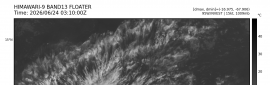
 照妖鏡
照妖鏡