EP, 13, 2014082412, , BEST, 0, 161N, 1108W, 130, 929, HU, 34, NEQ, 220, 180, 150, 150, 1008, 400, 15, 0, 0, E, 0, , 0, 0, MARIE, D,
EP, 13, 2014082412, , BEST, 0, 161N, 1108W, 130, 929, HU, 50, NEQ, 90, 90, 60, 60, 1008, 400, 15, 0, 0, E, 0, , 0, 0, MARIE, D,
EP, 13, 2014082412, , BEST, 0, 161N, 1108W, 130, 929, HU, 64, NEQ, 40, 30, 20, 30, 1008, 400, 15, 0, 0, E, 0, , 0, 0, MARIE, D,
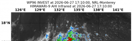
12Z速報給130KT
看15Z正報還會不會再調~

|


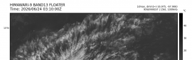
 照妖鏡
照妖鏡