開啟輔助訪問
 找回密碼
 立即加入

01L.Arthur 六年以來登陸美國本土最強颶風

簽到天數: 815 天

[LV.10]以壇為家III

martin191919|2014-7-3 17:06 | 顯示全部樓層
飛機實測應該達標,氣壓985mb,65kts


大西洋本年首個一級颶風已經生成,北卡沿岸已發hurricane warning


而今晚有可能受颶風影響,以及有繼續增強機會並上望75kts

AT 500 AM EDT...0900 UTC...THE CENTER OF HURRICANE ARTHUR WAS
LOCATED BY HURRICANE HUNTER AIRCRAFT AND NOAA DOPPLER RADARS NEAR
LATITUDE 31.3 NORTH...LONGITUDE 79.1 WEST. ARTHUR IS MOVING TOWARD
THE NORTH NEAR 9 MPH...15 KM/H. A TURN TOWARD THE NORTHEAST WITH AN
INCREASE IN FORWARD SPEED ARE EXPECTED TODAY...FOLLOWED BY A FURTHER
INCREASE IN FORWARD SPEED TONIGHT AND FRIDAY. ON THE FORECAST
TRACK...THE CORE OF ARTHUR IS EXPECTED TO APPROACH THE COAST IN THE
HURRICANE WARNING AREA TONIGHT.

DATA FROM NOAA AND AIR FORCE RESERVE HURRICANE HUNTER AIRCRAFT
INDICATE THAT MAXIMUM SUSTAINED WINDS HAVE INCREASED TO NEAR 75
MPH...120 KM/H...WITH HIGHER GUSTS. SOME ADDITIONAL STRENGTHENING
IS FORECAST IN THE NEXT 24 HOURS.


HURRICANE-FORCE WINDS EXTEND OUTWARD UP TO 25 MILES...35 KM...FROM
THE CENTER...AND TROPICAL-STORM-FORCE WINDS EXTEND OUTWARD UP TO 90
MILES...150 KM.

THE LATEST MINIMUM CENTRAL PRESSURE REPORTED BY THE NOAA HURRICANE
HUNTER AIRCRAFT IS 985 MB...29.09 INCHES.


同時亦預料帶來最高4英尺高的風暴潮

NORTH CAROLINA OUTER BANKS...2 TO 4 FT
PAMLICO AND ALBEMARLE SOUNDS...2 TO 4 FT
SOUTHERN NORTH CAROLINA AND NORTHEASTERN SOUTH CAROLINA...1 TO 3 FT
EXTREME SOUTHEASTERN VIRGINIA...1 TO 2 FT

本帖子中包含更多資源

您需要 登錄 才可以下載或查看,沒有賬號?立即加入

x

評分

參與人數 1水氣能量 +10 收起 理由
krichard2011 + 10 即時訊息

查看全部評分

回復

使用道具 舉報

簽到天數: 1696 天

[LV.Master]伴壇終老

jameshoe|2014-7-3 20:52 | 顯示全部樓層
本帖最後由 jameshoe 於 2014-7-3 20:55 編輯


來點不一樣的,上篇提到的飛機時測目前還在進行中,編號是NOAA 42和 NOAA 2,從佛州的坦帕機場起飛,以8000呎的高度,225 Kts的航速穿梭在颶風之中探測資料!

本帖子中包含更多資源

您需要 登錄 才可以下載或查看,沒有賬號?立即加入

x

評分

參與人數 2水氣能量 +30 收起 理由
krichard2011 + 15 好特別!
J18 + 15 好特別!

查看全部評分

回復

使用道具 舉報

簽到天數: 815 天

[LV.10]以壇為家III

martin191919|2014-7-3 21:12 | 顯示全部樓層
NOAA2在晚上8時實測往上升已達75kts


本帖子中包含更多資源

您需要 登錄 才可以下載或查看,沒有賬號?立即加入

x
回復

使用道具 舉報

簽到天數: 241 天

[LV.8]以壇為家I

krichard2011|2014-7-3 23:32 | 顯示全部樓層
雖然今年預測大西洋颶風偏少
但是第一旋就已經有不錯的強度
目前已經增強到 80kt了 上看 Cat.2
可見光也能看到明顯風眼 只是高層遲遲開不了

INIT  03/1500Z 32.4N  78.5W   80 KT  90 MPH
12H  04/0000Z 33.8N  77.3W   85 KT 100 MPH
24H  04/1200Z 36.3N  74.4W   90 KT 105 MPH
36H  05/0000Z 39.4N  70.2W   80 KT  90 MPH
48H  05/1200Z 42.7N  66.0W   70 KT  80 MPH...POST-TROP/EXTRATROP
72H  06/1200Z 48.5N  58.0W   50 KT  60 MPH...POST-TROP/EXTRATROP
96H  07/1200Z 55.0N  50.0W   35 KT  40 MPH...POST-TROP/EXTRATROP
120H  08/1200Z 60.0N  45.0W   35 KT  40 MPH...POST-TROP/EXTRATROP

本帖子中包含更多資源

您需要 登錄 才可以下載或查看,沒有賬號?立即加入

x

點評

第一個就比去年全部強  發表於 2014-7-4 01:26
回復

使用道具 舉報

簽到天數: 241 天

[LV.8]以壇為家I

krichard2011|2014-7-4 06:58 | 顯示全部樓層
本帖最後由 krichard2011 於 2014-7-4 07:10 編輯

風眼轉清晰...整體來說還挺漂亮的
但是這篇怎麼似乎挺少人在關注的 @@
有可能登陸北卡羅來納州或是從沿岸略過
不過剛剛看了一下南卡羅來納州的實測 似乎不是很給力
最大陣風出現在North Myrtle Beach, Grand Strand Airport
但只有每小時37英里 約16.54 m/s


本帖子中包含更多資源

您需要 登錄 才可以下載或查看,沒有賬號?立即加入

x
回復

使用道具 舉報

簽到天數: 3279 天

[LV.Master]伴壇終老

t02436|2014-7-4 11:36 | 顯示全部樓層

03Z給出85KT
正式衝上C2
FORECAST POSITIONS AND MAX WINDS

INIT  04/0300Z 34.6N  76.6W   85 KT 100 MPH
12H  04/1200Z 36.7N  74.5W   85 KT 100 MPH
24H  05/0000Z 40.0N  70.3W   80 KT  90 MPH
36H  05/1200Z 43.7N  66.1W   70 KT  80 MPH...POST-TROP/EXTRATROP
48H  06/0000Z 46.2N  62.6W   60 KT  70 MPH...POST-TROP/EXTRATROP
72H  07/0000Z 51.5N  54.0W   40 KT  45 MPH...POST-TROP/EXTRATROP
96H  08/0000Z 57.5N  44.5W   30 KT  35 MPH...POST-TROP/EXTRATROP
120H  09/0000Z 60.0N  35.0W   30 KT  35 MPH...POST-TROP/EXTRATROP


目前在北卡沿岸
從連續動畫可以看見中心正準備登陸


本帖子中包含更多資源

您需要 登錄 才可以下載或查看,沒有賬號?立即加入

x
回復

使用道具 舉報

簽到天數: 815 天

[LV.10]以壇為家III

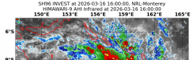
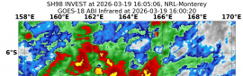
martin191919|2014-7-4 22:01 | 顯示全部樓層
加拿大氣象部門對東岸發Tropical storm warning

Tropical cyclone information statement for:

NEW BRUNSWICK
NEWFOUNDLAND
NOVA SCOTIA
PRINCE EDWARD ISLAND
QUEBEC MARITIME

For hurricane Arthur.

The next statement will be issued by 3:00 PM ADT.

Hurricane Arthur to impact Atlantic Canada with high winds and heavy rain this weekend.

1. Summary of basic information at 9.00 AM ADT.

Location: 36.5 north 74.8 west.

About 150 kilometres northeast of Cape Hatteras.

Maximum sustained winds: 150 km/h.

Present movement: northeast near 35 km/h.

Minimum central pressure: 973 MB.

2. Public weather impacts and warnings summary.

Tropical storm warnings are in effect for Digby to Yarmouth to Halifax counties. Tropical storm watches are in effect for the remainder of Nova Scotia and Prince Edward Island. Tropical storm watches are also in effect for portions of Southern and Eastern New Brunswick.

Hurricane Arthur is accelerating northeastward northeast of Cape Hatteras, North Carolina. A trough of low pressure is moving eastward from New England, guiding Arthur toward Atlantic Canada.

Landfall of Arthur is forecast to occur in Southwestern Nova Scotia Saturday morning as a strong storm at, or near, hurricane strength. Arthur is forecast to become a post-tropical storm as it tracks across Nova Scotia to lie in the Southern Gulf of St Lawrence Saturday night.

The public should pay close attention regarding weekend plans that may be sensitive to high wind and heavy rain conditions. It is emphasized that updated forecasts should be consulted for the latest forecast decisions and rationale. These are issued four times daily.

A. Wind.

Tropical storm warnings are in effect for Digby to Yarmouth to Halifax counties. Tropical storm watches are in effect for the remainder of Nova Scotia, Prince Edward Island, and portions of Southern and Eastern New Brunswick.

Strong winds are forecast on Saturday for much of the southern Maritimes with the strongest winds forecast to gust to 100 km/h over Southwestern Nova Scotia. Elsewhere over portions of the southern Maritimes, winds gusting to 80 or 90 km/h are expected.

In addition, it is likely that strong wind gusts will occur just as Arthur passes by for Southern and Eastern New Brunswick, Prince Edward Island, and the remainder of Nova Scotia by midnight Saturday night. Wind warnings may need to be extended to these regions later today.

Early Sunday morning, gusty winds are possible for portions of Quebec bordering the Gulf of St Lawrence.

During the day Sunday gusty winds are likely for parts of Newfoundland. However, winds are not expected to reach warning criteria.

B. Rainfall.

Heavy rainfall is forecast for all of New Brunswick and the Gaspé region of Quebec where rainfall warnings are in effect. Over these regions general amounts of 50 to 100 millimetres are likely with a good probability of higher amounts in some localities.

Heavy rainfall is also forecast for other regions adjacent to the golf of St Lawrence including Anticosti Island, lower Quebec Northshore and Northern Prince Edward Island where rainfall warnings may be issued sometime today. The rainfall rates are of particular concern since they could exceed 15 millimetres per hour during a period of several hours.

Over the southern Maritimes and Newfoundland, rainfall amounts are expected to be less. However, locally heavy downpours are likely over some areas.

C. Surge/waves.

Storm surge and large waves are possible with Arthur. High waves and pounding surf can be expected along the Atlantic coast of Nova Scotia Saturday morning and afternoon with the arrival of storm. High waves are also expected along the Southern Gulf of St Lawrence coastlines Saturday afternoon and evening.

High water levels at the coast could be an issue if the arrival of Arthur coincides with high tide. This timing will be assessed further as we get closer to the storm's arrival. Storm surge warnings may be required for Southeastern New Brunswick, the Northumberland Strait and parts of the Atlantic coast of Nova Scotia.

3. Marine weather impacts and warnings summary.

Hurricane force wind warnings are in effect for Lurcher and Browns Bank marine areas. Storm and gale warnings are in effect for the remainder of the Maritimes marine district.

Mariners should remain on alert and stay tuned for forecast updates.

Visit weather.gc.ca/hurricane (all in lower case) for the latest:

- forecast position, central pressure table.

- strength and predicted wind radii table.

- hurricane track information map.

- technical discussion.

Please also refer to the public and marine forecasts and warnings issued by Environment Canada for your area.

Forecaster(s): hatt/fogarty/couturier


本帖子中包含更多資源

您需要 登錄 才可以下載或查看,沒有賬號?立即加入

x

評分

參與人數 1水氣能量 +25 收起 理由
ben811018 + 25

查看全部評分

回復

使用道具 舉報

簽到天數: 815 天

[LV.10]以壇為家III

martin191919|2014-7-5 17:12 | 顯示全部樓層
減弱TS後即將登陸加拿大新斯科省

2:48 AM ADT Saturday 05 July 2014
Tropical storm warning in effect for:

    Fundy National Park

Tropical storm conditions - early morning to early morning Sunday.

Tropical storm-force winds of 60 gusting to 90 km/h over exposed areas from Hurricane Arthur can be expected over the above regions.

Arthur is moving rapidly towards southwestern Nova Scotia. Winds will increase this morning over southwestern New Brunswick and western Nova Scotia. Strong winds will reach eastern New Brunswick, Prince Edward Island, Cape Breton, and Iles-de-la-Madeleine this afternnon. Winds will gradually subside overnight tonight over western sections and on Sunday over eastern areas.

These winds could break tree branches potentially resulting in downed utility lines. Secure loose objects on your property and anticipate power interruptions. Stay away from the shore - the combination of surge and large waves could result in dangerous rip currents and the risk of being pulled out to sea .

A tropical storm warning means that tropical storm conditions (sustained winds near 65 km/h or more) are expected over parts of the region within 24 hours.

By nature a tropical storm also implies the threat of local flooding from heavy rainfall - consult your local area forecast for possible rainfall warnings.


本帖子中包含更多資源

您需要 登錄 才可以下載或查看,沒有賬號?立即加入

x
回復

使用道具 舉報

快速回覆
您需要登錄後才可以回帖 登錄 | 立即加入

本版積分規則

本平台僅供學術討論之用,預報應以氣象局為準

威普網站虛擬主機贊助公司

臺灣第一個天氣類型社群平台 即時天氣資訊、精準颱風動態

線上客服
FB傳送訊息
廣告行銷
精準行銷 物超所值
官方粉專
發佈 快速回復 返回頂部 返回列表