開啟輔助訪問
 找回密碼
 立即加入

01L.Arthur 六年以來登陸美國本土最強颶風

簽到天數: 815 天

[LV.10]以壇為家III

martin191919|2014-7-5 20:40 | 顯示全部樓層
Arthur已經登陸加拿大新斯科舍省西南部沿海,風力接近110km/h,開始轉化

8:45 AM ADT Saturday 05 July 2014
Tropical cyclone information statement  for:
NEW BRUNSWICK
NEWFOUNDLAND
NOVA SCOTIA
PRINCE EDWARD ISLAND
QUEBEC MARITIME

For post-tropical storm Arthur.

The next statement will be issued by 3:00 PM ADT.

Arthur affecting the Maritimes as a still very strong post-tropical storm giving rain and strong winds.
1. Summary of basic information at 9.00 AM ADT.

Location: 44.2 north 65.9 west.

About 45 kilometres north-northeast of Yarmouth.

Maximum sustained winds: 110 km/h.

Present movement: northeast near 30 km/h.

Minimum central pressure: 980 MB.

2. Public weather impacts and warnings summary.

Tropical storm warnings are in effect for Nova Scotia, Prince Edward Island, Southern and Eastern New Brunswick and iles de la Madeleine.

Post-tropical storm Arthur is moving over Western Nova Scotia this morning, under the influence of a cold front over New Brunswick.

Landfall occured this morning around 7:30 AM ADT as a strong post-tropical storm in the vicinity of meteghan and Port Maitland Nova Scotia. Maximum winds were near 110 km/h. Arthur has transformed into a still very potent post-tropical storm and will be tracking across Nova Scotia. It will move into the Southern Gulf of St Lawrence this evening.

The public should pay close attention regarding weekend plans that may be sensitive to high wind and heavy rain conditions. It is emphasized that updated forecasts should be consulted for the latest forecast decisions and rationale. These are updated every three hours.

A. Wind.

Tropical storm warnings are in effect for Nova Scotia, Prince Edward Island, portions of Southern and Eastern New Brunswick and iles de la Madeleine.

Strong winds are forecast today for much of the Maritimes with the strongest winds possibly gusting to 120 km/h over exposed coastal locations of Southwestern Nova Scotia. Elsewhere over portions of the southern Maritimes, winds gusting to 90 km/h are expected. Tree damage and downed utility lines should be anticipated. Numerous power interuptions especially in areas with the strongest winds can be anticipated.

In addition, strong west to northwest wind gusts will occur as Arthur passes by for Southern and Eastern New Brunswick, Prince Edward Island, and the remainder of Nova Scotia. Strong gusty winds are also expected for portions of Quebec bordering the Gulf of St Lawrence.

During the day Sunday gusty winds are likely for parts of Newfoundland. However, winds are not expected to reach warning criteria.

B. Rainfall.

Heavy rainfall is forecast for all of New Brunswick. For Quebec the main threat is for Gaspé and east as well as the basse cote nord area of Eastern Quebec and Anticosti Island. Over these regions general amounts of 50 to 100 millimetres are likely with a good probability of higher amounts possibly exceeding 150 millimetres in some localities. For New Brunswick storm total amounts near 100 millimetres are forcast except for the extreme northwest and southeast.

The rainfall rates are of particular concern since they could exceed 15 millimetres per hour during a period of several hours. These conditions could lead to local flooding of small rivers and creeks and possible road washouts.

Over the southern Maritimes and Newfoundland, rainfall amounts are expected to be less. However, locally heavy downpours are likely over some areas.

C. Surge/waves.

High water levels at the coast could be an issue if the arrival of Arthur coincides with high tide. Fortunately the storm is passing through the region during a period of low astronomical tides, known as neap tides, and in many locations the storm surge will not be in phase with the high tide itself, for instance when the system reached the coast near Yarmouth.

Large waves giving heavy pounding surf are expected along the Atlantic coast of Nova Scotia and Newfoundland. Wave heights are expected to be 5-7 metres near the coast this morning for the southwest shore, and later today and this evening for the eastern shore and Cape Breton. For offshore Maritimes waters wave are expected to reach 6-8 metres. Waves of 4-6 metres are expected Sunday for Southern Newfoundland.

3. Marine weather impacts and warnings summary.

Storm and gale warnings are in effect for the Maritimes marine district.

Mariners should remain on alert and stay tuned for forecast updates.

Visit weather.gc.ca/hurricane (all in lower case) for the latest:

- forecast position, central pressure table.

- strength and predicted wind radii table.

- hurricane track information map.

- technical discussion.

Please also refer to the public and marine forecasts and warnings issued by Environment Canada for your area.
Forecaster(s): fogarty/couturier


本帖子中包含更多資源

您需要 登錄 才可以下載或查看,沒有賬號?立即加入

x
回復

使用道具 舉報

簽到天數: 815 天

[LV.10]以壇為家III

martin191919|2014-7-6 10:47 | 顯示全部樓層
加拿大氣象局表示Arthur登陸芬迪國家公及愛德華王子島

FXCN31 CWHX 060000
Tropical cyclone technical information statement issued by the
Canadian Hurricane Centre of Environment Canada at 8.43 PM ADT
Saturday 05 July 2014.

The next statement will be issued by 3.00 AM ADT

1. Current position, strength, central pressure and motion

At 9.00 PM ADT, post-tropical storm Arthur was located near latitude
46.9 N and longitude 63.6 W, about 79 nautical miles or 146 km
west-southwest of i'les de la Madeleine. Maximum sustained winds are
estimated at 50 knots (93 km/h) and central pressure at 980 MB.
Arthur is moving east-northeast at 18 knots (33 km/h).


2. Forecast position, central pressure and strength

Date     time     lat    lon   MSLP  Max wind
          ADT                    MB  kts  kmh
Jul 05  9.00 PM  46.9N  63.6W   980   50   93 post-tropical
Jul 06  3.00 AM  47.3N  61.6W   985   50   93 post-tropical
Jul 06  9.00 AM  48.2N  59.7W   985   40   74 post-tropical
Jul 06  3.00 PM  49.5N  57.5W   985   35   65 post-tropical
Jul 06  9.00 PM  50.8N  55.5W   995   35   65 post-tropical
Jul 07  3.00 AM  52.8N  54.2W   988   35   65 post-tropical
Jul 07  9.00 AM  54.6N  53.1W   988   35   65 post-tropical
Jul 07  3.00 PM  56.4N  52.0W   988   35   65 post-tropical
Jul 07  9.00 PM  58.3N  50.7W   990   35   65 post-tropical
Jul 08  3.00 AM  60.3N  49.6W   992   35   65 post-tropical


3. Technical discussion

A. Analysis

Post tropical storm Arthur made yet another landfall this afternoon
near Fundy National Park. The center of the still very intense and is
located near Prince Edward Island. The moisture wrapping on the
western side of the storm is associated with the baroclinic band
which extends from Labrador to Maine.
Radar imagery shows a large
area of heavy rain embeded in the band especially over Eastern Maine
and New Brunswick where storm total reports of 140 mm have been
received. Nova Scotia is experiencing the strongest winds and gusts
in the 55 to 75 knot range have been reported by land and marine
stations in the southerly circulation ahead of the storm. Also a
sting jet has developed on the rear flank of the storm resulting in
westerly gusts between 55 to 75 knots.

B. Prognostic

The forward speed of Arthur has been constant during the past few
hours and is moving east-northeast at about 18 knots.  The storm will
track eastward across the Southern Gulf of St Lawrence as a strong
post-tropical system and then across Newfoundland Sunday before
exiting into the North Atlantic as a weakening baroclinic system. The
track has been shifted slightly to the north to reflect the current
isobaric field over the region.

C. Predicted wind radii (NM)

Time          gales           storms            hurricane
         Ne  se  sw  nw    ne  se  sw  nw    ne  se  sw  nw
06/00Z  150 195 155  90     0   0   0   0     0   0   0   0
06/06Z  160 205 160 100     0   0   0   0     0   0   0   0
06/12Z  165 215 160  95     0   0   0   0     0   0   0   0
06/18Z  170 230 160  90     0   0   0   0     0   0   0   0
07/00Z  190 235 160  70     0   0   0   0     0   0   0   0
07/06Z  205 235 160  45     0   0   0   0     0   0   0   0
07/12Z  230 260 160  30     0   0   0   0     0   0   0   0
07/18Z  250 265 160  15     0   0   0   0     0   0   0   0
08/00Z  250 250 160  10     0   0   0   0     0   0   0   0
08/06Z  270 255 160   0     0   0   0   0     0   0   0   0


END/MERCER/COUTOURIER


本帖子中包含更多資源

您需要 登錄 才可以下載或查看,沒有賬號?立即加入

x

點評

第一次看到加拿大對後熱帶氣旋如此密集發報  發表於 2014-7-6 12:38
回復

使用道具 舉報

簽到天數: 815 天

[LV.10]以壇為家III

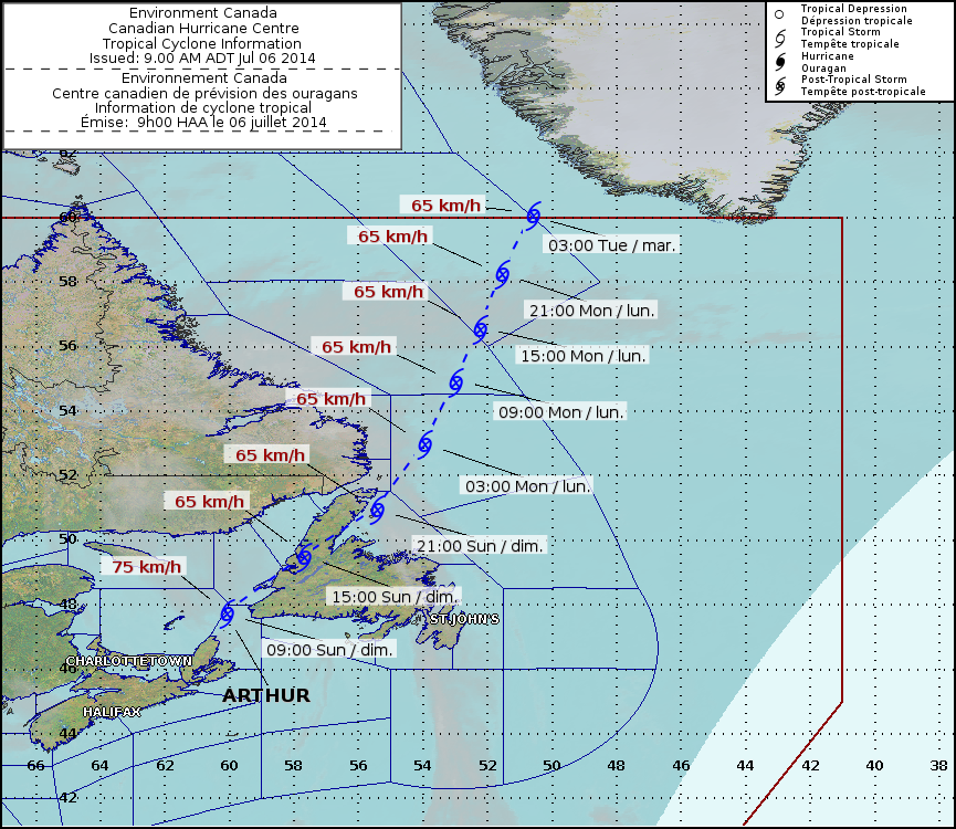
martin191919|2014-7-6 22:44 | 顯示全部樓層
加拿大氣象部門解除所有熱帶風暴警報

8:45 AM ADT Sunday 06 July 2014
Tropical cyclone information statement  for:
NEWFOUNDLAND
NOVA SCOTIA
PRINCE EDWARD ISLAND

For post-tropical storm Arthur. The next intermediate statement will be issued at 12:00 PM ADT. Remnants of weakened Arthur moving north eastward. Final statement planned for midday with full meteorological summary.

1. Summary of basic information at 9.00 AM ADT.

Location: 47.8 north 60.1 west.

About 75 kilometres west-northwest of port-aux-basques, Newfoundland.

Maximum sustained winds: 75 km/h.

Present movement: north-northeast near 40 km/h.

Minimum central pressure: 984 MB.

2. Public weather impacts and warnings summary.

All tropical storm warnings ended.

Repeat: a final storm report is planned for midday with all the details of wind speeds, rainfall and meteorological analysis.

Remnants of post-tropical storm Arthur are nothing more than some lingering gusty winds and a few pockets of heavy showers (Newfoundland and Cape Breton).

3. Marine weather impacts and warnings summary.

Gale-force wind warnings still remain over a number of areas.

Visit weather.gc.ca/hurricane (all in lower case) for the latest:

- forecast position, central pressure table.

- strength and predicted wind radii table.

- hurricane track information map.

- technical discussion.

Please also refer to the public and marine forecasts and warnings issued by Environment Canada for your area.
Forecaster(s): fogarty


本帖子中包含更多資源

您需要 登錄 才可以下載或查看,沒有賬號?立即加入

x
回復

使用道具 舉報

1234
快速回覆
您需要登錄後才可以回帖 登錄 | 立即加入

本版積分規則

本平台僅供學術討論之用,預報應以氣象局為準

威普網站虛擬主機贊助公司

臺灣第一個天氣類型社群平台 即時天氣資訊、精準颱風動態

線上客服
FB傳送訊息
廣告行銷
精準行銷 物超所值
官方粉專
發佈 快速回復 返回頂部 返回列表